Monday, August 29, 2011

Site Updates & 5000th Page View

I am sure that you have a noticed I've gone with a couple of different templates for my page recently. I am still trying to get the feel of things, so pardon my appearance if something looks out of place or a link is not fresh while I try to bring you more content.

5000 Page Views
The month of August 2011 has been a great month for my page, for the first time, I have 1000 page views in a 30 day period, and I have just reached 5000 page views. It makes me feel good to see these stats, particularly after I've posted some of my popular posts. This is thanks to family and those of you I have engaged with online in the hiking community. Having this site is great because I am able to share my adventures and I have something to be able to always look back at them. 

Updated Navigation Tab
Since I have completed the White Mountain 4000 footers, I have made a change to the navigation on my site. My focus has shifted from my 2011 Quest to some of the other peak lists, which I hope to work on over time; no more time goals for now. I have replaced my 2011 Quest tab with a new tab, Peak Lists. This is a dedicated page where you can find a link to my AMC White Mountain 4000 footer's list, as well as the other popular peak lists. Each peak list with a link shown on the page currently has its own page with an embedded Google spreadsheet, which is updated automatically when changes are inserted using my Google Documents. Creating tables in blogger is a hassle, and this is the easiest thing I've found so far.

Updated Posts
I realized that my posts throughout the year were missing some important information, particularly information used to plan hikes. I have edited all of my prior posts with hike stats, which include the trails used, mileage, and elevation gain. When I get around to it, I will post my book times. I have kept all of these stats for my hikes, but I've done so much recently, the information is spread among Google docs, Microsoft excel, word lists, you name it. I'm trying to figure it all out and find the best way to keep track of it all.

Favicon
Since I continue to slowly learn more about blogging, I have finally updated my favicon. The favicon is the icon that you see at the top of the page, next to the web address, or on the title bar. You might also see my favicon on other websites that have a link to my page. This replaces the plain old blogger symbol.

If you are not seeing any of these changes, clear your cache. If anyone has any suggestions for or questions about my website please click here and contact me via e-mail. Thank you to all those who have already joined me here or on Facebook and Twitter.

Best Regards,

Dan

Saturday, August 27, 2011

Grafton Loop Trail - August 22-23, 2011

The Grafton Loop Trail is a 38.6 mile loop through Grafton Notch with commanding views of the Mahoosuc Range. The first parts of the trail were open in 2003, so it is very new, and I did not have a whole lot of information other than the Grafton Loop Trail Map from the AMC's page about the loop, which was the only map I needed during this trip. The trail passes over Old Speck Mountain, a Maine 4000 footer and Baldpate East, which is one of New England's 100 Highest. The other 3000 footers I'll talk about pack a punch. The trail was beautiful in every unique section, and I recommend it. I went for nearly 20 miles without seeing another person. Most do it as a 2-3 day backpack, but I had so much fun on the trail, I did it overnight...with way too much gear!

Hike Stats
Total Elevation Gain: 10,500ft

Day 1
Grafton Notch AT Parking Lot to Stewart Campsite
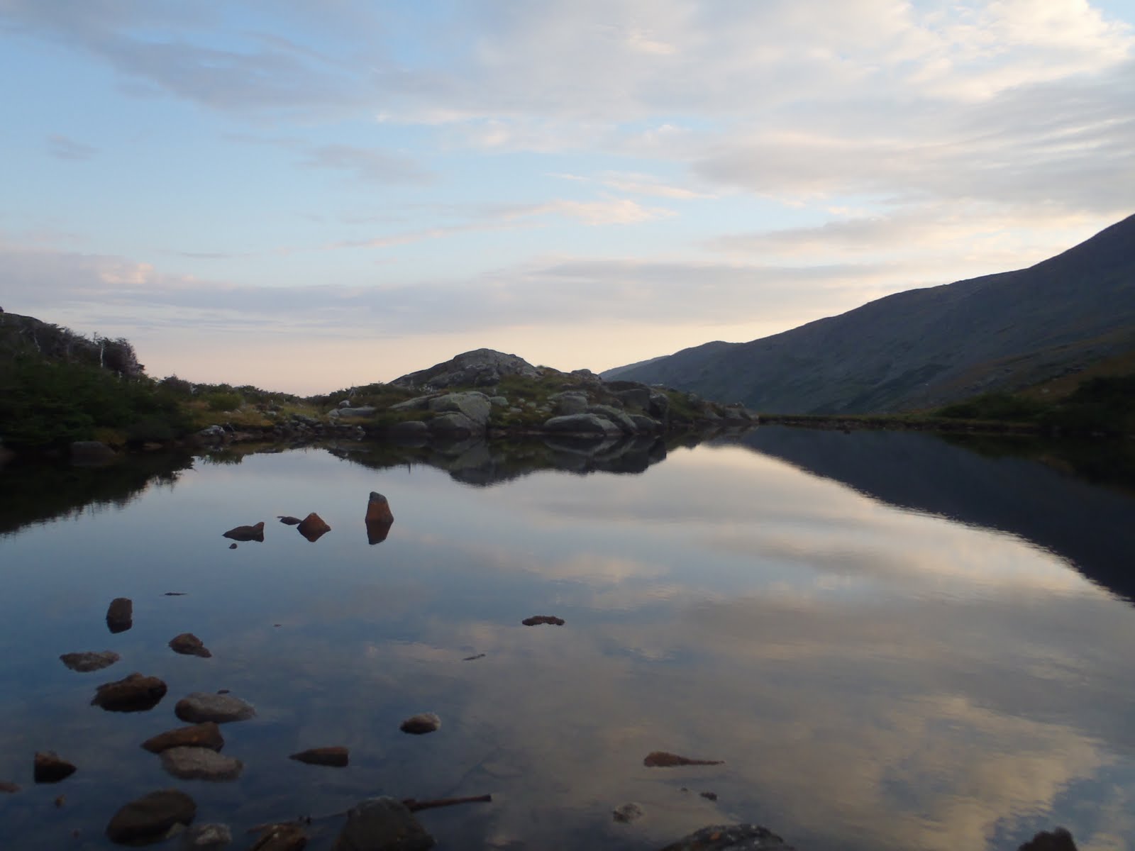
Old Speck 4170'
Sunday River Whitecap
Bald Mountain
Puzzle Mountain
22.4 miles

Day 2
Stewart Campsite to Grafton Notch AT Parking Lot
Long Mountain
East Baldpate
West Baldpate
16.2 miles

Without much information to go off of, I chose a counter clock wise route. This would get Old Speck done early, and give me two options for camp...Sargent Brook or Stewart Campsite. I headed up the Old Speck Trail, which is the Appalachian Trail Southbound from this main hub parking lot for the AT. The trail is pretty steep with lots of roots. It was also very wet and muddy at times. The sun was out and the trail passed a beautiful stream flowing off the mountain. I had passed 2 people coming down, to this point. Getting closer to Old Speck, the trail, although tricky already began to show off its beauty with the suns rays and deep green colors. I came to the junction with the Mahoosuc Trail, which takes the AT into NH. I headed on the Grafton Loop Trail towards Old Speck.
Waterfall on Old Speck
Morning rays and lush greenery on Old Speck Trail
The summit was socked in by heavy fast moving clouds. Here I saw the 3rd person on the trip, who was heading in the same direction. I explored the observation tower on my first Maine 4000 footer, Old Speck. Its a steep gradual climb, and on a clear day, I know how beautiful the view would be. After the climb, it was still rewarding to stand on the deck and cool off in the whipping wind. Before I started to freeze thought, I came down, put on my jacket to regulate my temperature and had a snack. I was now off south on the Grafton Loop Trail.
Old Speck Mountain Observation Tower
This next part of the trail was one of the most beautiful on the whole stretch. It descends Old Speck and passes through beautiful mountain woods around the side of Slide Mountain and into Miles Notch. If you hate pointless up and downs, this trail is not for you, its the name of the game here. Except this trail provides some great flat areas with open woods. I was wishing and hoping to see a moose or other wildlife, but I didn't see anything other than a cool caterpillar, a garter snake, bird, and field mice. There was deer poop every quarter mile, but didn't see any, but the scenery never disappointed.
Me on a straight, open woodlands section
After this beautiful stretch of trail, it ascends to Sunday River Whitecap at 3335'. Here I saw two women descending who said the wind was really strong on the summit. I threw on the jacket and my hat because I was wet and headed for the summit. There was lots of great trail work up here to help with the fragile environment. The summit was very impressive for its elevation, including a nice summit marker. The views were fantastic.
View from Sunday River Whitecap
From Sunday River Whitecap, it's 7.1 miles to Route 26, where the trail crosses. This was a very long descent to the road, but and I did it in a little over 3 hours. I ended the 17.5 mile western section by passing a large field on private property and crossing the Bear River Suspension Bridge. It was just before 3pm, and I had a .6 mile walk north on Route 26 to get to the Eddy Road trail head to continue. Then, it would be 5 miles to the Stewart Campsite. I was already committed to getting there because there is no camping except at designated sites, as many of it is private land (although you would never assume it if they didn't tell you).
No problem bringing a stove to experience this trail overnight
So I walked the road to the parking lot and started up towards Puzzle Mountain on the Eastern side of this loop. Puzzle Mountain was a tough 3000 footer. There are several tricky ledges near the top requiring attention (especially with a heavier pack than normal), except several separate sections of ledges afford views backwards towards Sunday River Ski Resort. The trail passes over the summit, and descends into the valley north of the mountain.
View from near the summit of Puzzle Mountain
Yes, it was just after 5pm, and I had less than 2 miles to go to the campsite. I was off down the trail, knowing I would make it in time, before sunset. The Stewart Campsite had an upper and lower section. I pitched my tent on the lower section away from the main section. The brook was rather unreliable, although I could have filtered water through what was there if I had to. I cooked my food and when finished put all of my food items into my bag and hung it up near the upper section of the camp site. The woods were pretty thick, and the slope was tough besides at the site, and you don't want to hang a bag upslope. The sites are raised earth tent pads.
My tent spot at the lower section of Stewart Campsite
I hung my bear bag around 7:45pm, and went down my tent. When I woke up the next morning and broke down camp. I went up to the upper camp to find two tents, a tarp tent and gear for an army. Their several food bags were hung on a line at a height at which an army of bears could grab. My bear bag might been hung sort of in the middle of everything, but it was done right about 15 feet up, not on string next to my tent. I don't even think they saw it. So it was like 8:30am, and everyone was sound asleep as I quietly untied my bag and lowered it into my hands. I went up the trail a bit to cook my hot granola breakfast and instant coffee. I couldn't believe it; it was rather funny to wake up to, I heard not heard a thing during the night, I have no idea what time they arrived.

After the Stewart Campsite, the trail straightens out and makes a very long and tiring ascent up Long Mountain through varying terrain. Its so long it, at times it doesn't feel like you're ascending a mountain. The trail was often overgrown here. Although overgrown, the path is well laid out through all of the overgrowth. There were sections like this in every quarter of this loop, which makes it a great experience. Despite this, there was not a worry about getting lost. The trail is so well marked, you could save the weight of the map.
The trail parallels the edge of a cleared section on way to Long Mtn.
I hadn't taken the spurs to the campsites along the way, but it was recommended to me on Old Speck to take the spur for the view on Long Mountain. After I finally made it there, I dropped the pack and bolted up the spur. There was a bench at the top overlooking the mountains. It was a great closed in, unique spot in the wilderness.
Water break at Long Mountain view point
After Long Mountain, the terrain was beautiful again. I was hiking and crossing more streams, a couple of which I re-filled at. (click link to see video) The trail passes along several great rock formations along this section, as well as some great alpine-like sections on the ascent up the side of Baldpate. On the way is Lightning Ledge, a viewpoint from which you can see exactly how far you've come.
View from Lightning Ledge, Grafton Loop Trail
Large blow down blocking trail
Lightning Ledge is still more than 2 miles before East Baldpate, so there was more to go. There were very little blow downs throughout the whole trail. However, right before the East Baldpate Campsite, I encountered an enormous group of blow downs blocking the trail at a switchback. There was a well-beaten dead end path that went right about 50 feet, but I finally discovered it went down to the left. There is a rock section with iron rungs to climb. This was not a walk in the park with a heavier pack than normal, especially when you want to turn your head quickly for the view, because it's nice.

I finally made it to the summit of East Baldpate Mountain, realizing I'm nearing the end of this trek in great time for the day, considering I didn't get going until after 8:30am. The summit, one of New England's Hundred Highest has one of the most expansive and impressive views I have seen. The outline of the soaring Presidential's was clearly visible in the background, and the mountains and lakes in all directions make East Baldpate a top peak when it comes to 360 degree views.

Me near the summit of East Baldpate
Here, the Appalachian Trail joined, and the trail followed the wide summit towards the road, and the views become even better as West Baldpate and the cairns marking the descending path ahead came into view. The wind made the descent tricky, but I was locked in and made it a quick descent.

Getting more tired now, I passed over the west peak of Baldpate, which is signed. After that, it's all downhill from here. There are maintained trail steps most of the way down the slopes of West Baldpate all of the way to the AT parking lot, where I was parked. It was tough going down on these, so I took a few breaks, but when I wasn't taking a break, I was letting gravity do most of the work (with careful foot placement). At about 1 mile to go, I passed a couple with a little boy who hurt himself in some way. I offered any assistance, but they said they would be fine. I also passed a couple of groups going up. These were the first people I had seen all day, in about 8 hours. I eventually made it down to road. The trail crosses the street to the trail head bulletin board and parking lot.

This trip was well worth it. I am often less inclined to visit areas that are on private lands, or that have strict rules, like no off-trail camping, but with the Grafton Loop, you wouldn't know you were on private land if they didn't tell you. The variety of terrain and remoteness and ruggedness of the trail make this trail feel like an adventure. Although you can hear the road from the Stewart Campsite and some other portions of the trail, the majority of it is silent beautiful woods. The trail travels through quiet and open woodland areas where you can see large distances through the trees, as well as parts that are tightly closed in. It makes you feel like you're in the middle of nowhere. This trail is well worth the visit if you have not hiked this area.

To view the full album, click on the slide show below.


Friday, August 26, 2011

The Kinsmans & Bald Peak 8-20-11

On Saturday, August 20th, my brother and I went to get the Kinsmans. In April, Bill and Sean did not get the Kinsmans, so we were back getting two more for Bill. If possible, we try to hit a trail I haven't taken before. We went for the Mt. Kinsman Trail. The parking lot has been relocated south down the road. There is a small laminated paper explaining the details. We parked in the lot and started up the trail. Don't pay attention to the guide where it says stay right at any forks. From the parking lot, when you come to a three way, about a half mile in, go towards the sign, and take a right onto the logging road.

The Mt. Kinsman Trail is indeed tougher than a glance at the map indicates. It was a challenge after what we did the week before. The trail was littered with many different types of mushrooms. The ground was damp and wet, and so they stood out. We decided to take some macro pictures, and they came out pretty good. We came to the Bald Knob Spur and banged a right. It was an impressive view to the southwest and also right up to the mountainside of the Kinsmans. We ate our lunch here. It felt like lunch time already after the laboring trip up so far. We continued along the Mt. Kinsman Trail, and it seemed like forever again until we reached the Kinsman Ridge Trail, really tough going on the upper sections.

Once at the junction, the summit of North Kinsman is just up ahead. In the winter, I didn't have the opportunity to stand on the ledge. I had just stood at the high point. The views were great, and Lafayette and Lincoln look large from Kinsmans. We had some more food and water at the summit and stretched the legs out over the ledge for a few minutes.

There were other hikers enjoying the summit, so when finished we pushed towards South Kinsman on the Kinsman Ridge Trail. I remember doing the trail in the winter, the snow was so deep, the trees were just a foot or two tall. Its harder in the summer, its very rocky and rooty and requires two hands sometimes for rock scrambles. Its fun. And when its flat, you get nice views. As we approached South Kinsman, we could see about 30 people on the summit. We head straight for the cairn to add another for Bill, and for me to knock South Kinsman off the Trailwright 72 list. I know have 25 of 72 on the list after going through my hikes to the 48.

On the way back, North Kinsman looks so prominent. It doesn't feel like it looks from that angle. With other hikers enjoying the North summit on the return, we kept heading down the trail. We took the spur trail to see the Kinsman Flume. Don't go flying down that trail too fast, now, especially if wet or icy. It's not a very spectacular thing to see, but its impressive. You wouldn't want fall down there. I don't think I would bring a young child down to see this Flume.

At the trail head, there is a sign for the Adopt-A-Trail Program for the Mt. Kinsman Trail. Bruce Richards is shown here doing a number on a tree somewhere on the trail. An additional sign near the end of the new path from the parking lot would help. The newer trail sign near the old logging road should face where the new trail comes from. Some people, like us, might end up on the logging roads to the south, a whole mile or more off the trail! But seriously, thanks Bruce, for your hard work!

Hike Stats
Trails: Mt. Kinsman Trail, Bald Knob Spur, Kinsman Ridge Trail
Distance: 10.4 miles
Elevation Gain: 3900ft
Book Time: 7:45

To view the full album, including some cool mushroom shots, click on the slide show below.

Thursday, August 25, 2011

Moonlight Presidential Traverse 8-13-11

When you think about doing a hike such as the Presidential Traverse, you can only hope and wish for good weather on the date of your hike. Try hoping and wishing for months. Even before I was halfway done with the list, I was thinking about taking care of the Presidential's as a traverse, after all I tried before. I had been looking for full moon dates around that time and there was only August and December with a full moon on a Saturday. August 13th it was. My brother was ready...having done the Wildcat, Carters overnight, Bonds, and Trips with me in the weeks leading up to it. At about two weeks before, I started looking up the sunset times, sunrise times, moonrise, moon set, twilight, all of it. I looked up the weather history for August so to know the extremes, the possibilities...Only a week or so before did Bill inform me that it would be the day after the peak of the Perseid Meteor showers, and also that the International Space Station would be visible.

Saturday, August, 13, 2011
Full Moon 2:58pm / Moonrise 7:31pm / Sunset 7:53pm / Twilight Ends 8:25pm / Sunrise (8/14) 5:46am

Warning sign at Valley Way
Being able to start in the afternoon enabled us to eat a nice breakfast, a bacon and cheese omellete made by Bill. Then, we got our stuff together, hit the road, and stopped into camp at Winnisquam for a half hour to say hi to Mom and Dad, then we were off again. We were in separate cars, leaving mine at Mt. Clinton Road and then heading to Appalachia. We arrived at Appalachia around 3pm. It was great having time. We were in comfortable clothes right to the parking lot. After changing into our gear and getting the last couple of items in our light packs, at 3:30pm we were off up the Valley Way Trail. We had been hearing word of the incoming front, but at camp, and from looking at the higher summits forecast, we learned the front had been delayed, lessening the chance of incoming weather on Saturday but if you know anything about Mt. Washington, you have to be prepared for the possibility of some snow and heavy winds, you never know. 

I was sure bad at remembering the Valley Way, it was a gradual tough ascent for a while long before I saw the winding section I had remembered and thought went for much longer!! We had planned out a sneak attack from the back to Mt. Madison by opting for the Watson Path instead of staying on the Valley Way. This would allow us to continue moving forward rather than an up and back from Madison Hut. The Watson Path was beautiful, Its rocky, rooty, has large boulders and is pretty steep. This beautiful waterfall pictured to the side greeted us along the way, you can see the steepness. After the waterfall it continued steeply through shortening trees for a little bit and then eventually into the scrub. As we passed the last of the trees, it was around 6:00pm. There was the late afternoon haze casting rays over the ridge, and it was really calm.

Last minutes of the sun on 8/13
Mt. Madison has really large boulders near its summit, its not an easy ascent, and I remembered this. It was to be Bill's halfway point, so he lead the way to the summit. It was just minutes after 7pm when we arrived, and we were taking in the incredible views to the valley and Mt. Washington. It was a great start, fair weather, light breeze, feeling good. We left on the Osgood Trail down to the hut, over the large boulders. We got the last glimpse of the sun before sunset, shown to the left, around 7:45pm.

Full moon against the sharp boulders
We arrived at Madison Hut, and the place was bustling like the local bar downtown at happy hour. We walked in to fill up our water. We also drank 16oz each while there, and filled up again. Light was fading fast, and as we were leaving the hut, just minutes after we got there, the group of older adults sitting outside of the hut asked what our plan was, and when we answered, they said, "Good luck with thaat" in that kind of sarcastic way you've probably heard. Well just as we started up the Gulfside Trail, the moon was rising in the east. It was incredibly impressive against the deep blue sky. Although the sun out of sight, its light stayed until we were on the way up Airline to Mt. Adams. As we made our approach, the only light we had was the moonlight, and it was still more than enough. We reached the summit of Mt. Adams at exactly 9pm, and it felt like the moon was right there. We quickly sat against a rock and had a snack. At the same time we began to look to the sky. Immediately, I saw the first meteor, and then just minutes later, we saw a star that was the brightest in the sky, close to the moon. Bill pointed it out, and I looked and saw, we turned our heads, and then it was gone. We are certain that it was the ISS because it was going to be viewable for only a few minutes starting at 9:07pm. Its not like anything amazing happened, it was just there and then gone. We also saw Venus following the moon the entire night. After a good break and summit pictures with the moon, we were heading towards Thunderstorm Junction.

Me on Jefferson, #46
Clouds and moon from Jefferson
As we approached the junction, still using only the moonlight as our aid, we saw a group camped out in sleeping bags taking in the beautiful night. If you don't pay close attention, its very easy to end up on Lowe's Path going in the wrong direction. I did this last year with my crippled knee, and vowed not to do the same. We veered left and got the Gulfside Trail again. This section up to Edmands Col seemed to take a long time. There's some pretty steep sections right here before approaching the cone of the Jefferson, even some loose dirt and rocks. As we continued up Mt. Jefferson, the moon was always visible against the black sky, and there was always only a small portion of the stars blocked by moving clouds. Once on the Jefferson Loop Trail, we occasionally needed additional light to look for the cairns. Some of the cairns are just a few rocks on top of a flat rock. When you reach the top, there is a large tall cairn, and to the right, about 30 more feet up is the summit. We could see lights flashing down on route 2, and some sort of signal light, and of course, the moon was bright, and at this point, clouds were teasing a little bit with the moon, but it was still bright enough. A solo north bounder doing the same as us (except with a full pack and sleeping gear) met us on the summit of Jefferson for a quick chat, and then we parted ways.

Sunrise?.....or
......Moonlight?
Next up was Mt. Clay, it was still a bit cloudy as we passed over the summit, but then after that, the clouds dissipated and it became clear and calm. As we ascended the last part of the cone of Mt. Washington, it was dead silent and hardly a breeze. We approached from the rear of the Tip Top House and climbed the boulders to the summit marker; (besides the people in the building) we were the only ones on the summit. This was #47 on my 2011 quest, and my third time to the summit of Mt. Washington. Bill enjoyed his first summit of Washington. What an experience to have the bright and clear full moon to the west and dark, early sunrise to the east when reaching the summit. We hung around for about a half hour at the summit to watch the sunrise. It was about 48 degrees, but it felt much cooler.

It was starting to lighten quick, but as we descended Mt. Washington on the Crawford Path the sun was blocked by the mountain. Down below, I could see the hut, and just beyond it, was Mt. Monroe. I was approaching my last peak of the 48. There was a golden glow over the summit with Washington casting its shadow on the lower cone. As we got closer, we could see the people bustling at the hut. Lake of the Clouds looked as amazing as ever. We parked at the hut, drank water, and refilled our water and ate a breakfast muffin we bought at the store. Thankfully it was beaten to crumbs.

Lake of the Clouds
As we left the hut, it was hard to grasp that I was actually finishing this. Having come down Crawford Path before, Monroe had never looked so good. I lead the way up the fun summit cone. It's an easy path but it was pretty fun climb. I thought about all of the summits before as I took in the moment while nearing the summit marker. Bill captured some great shots of me getting the summit. I really lucked out with all of the planning and the weather. I couldn't have asked for a better way to finish this, a moonlight Presidential Traverse.
Approaching the summit of Mt. Monroe
Me on Monroe, my 48th summit
Bill on Eisenhower
After Monroe, our legs were pretty tired. We passed over Mt. Franklin and took in the nice view of the Dry River Wilderness, with the Presidents getting taller over our shoulders. Eisenhower was a struggle, but we made it. I was telling Bill not to worry, the rest wasn't that bad. It was clouding up, but the views were still great from Eisenhower. Getting across to Pierce was not bad. I was able to get my summit picture on Pierce, since my first one is on my lost camera. We were happy to get Pierce, and all of the Presidents, so we opted to leave Jackson and Webster for another trip. (We'd have more energy to look for my camera)

We slowly made our way down the Crawford Path with our legs burning. It started to rain, so on went the rain jackets. The rocks started to get slippery, and the Crawford Path is not bad when dry, but wet is a different story. Either way, its a pretty trail.


This trip was certainly one to remember. The weather turned out perfectly, and all of the planning paid off and I don't know what could have made it better. Besides the people at the huts and the few we saw, it felt like we were the only ones on the mountain, and on such a special trip to complete the 48, it was more than I ever expected.

Hike Stats
Trails: Valley Way Trail, Watson Path, Osgood Trail, Gulfside Trail, Airline Trail, Jefferson Loop, Clay Loop, Monroe Loop, Eisenhower Loop, Crawford Path, Webster Cliff (for Pierce)
Distance: 19.5 miles
Elevation Gain: 8,500 ft

Click on the slide show below to see the full album. Also below is a compilation of video footage from the trip, including me finishing on Monroe.


Friday, August 12, 2011

The Difference a Year Makes

Evening descent down Crawford Path - Aug. '10
About one year ago to the week, in August of 2010, I crazily set out to attempt a Presidential Traverse. I want to take a few minutes to reflect on that trip, and talk about the difference a year makes, a year of a ridiculous amount of hiking. Things were different then, and I was much less experienced than I am now. After all, my pack then was over 30lbs. I had a tent with me, as I planned to make it more than halfway and camp in the Dry River Wilderness. However, after I came down from the summit of Madison, my knee had gradually developed some serious pain; what I found later in the year to be a possible patella femoral syndrome, however I question that vague diagnosis. I hiked to the summit of Adams and then skipped the rest of the peaks all of the way to Washington walking the Gulfside Trail in serious limping pain. Despite the pain, I took it in stride and didn't think to much about it not working out this time. I had to get down.

One thing I miscalculated about the Ammo Trail was how soon I would be able to find a spot for the tent. I hobbled until midnight when I found a flat spot. It was a relief to get it pitched and fall asleep. I had slept in until about 9, packed up, and had a very short hike out, where I was picked up at the Cog.

With all of that now a part of history, I make my way up the same trails this weekend - one year later. The difference is that in 2010, I had not hiked any other 4000 footers, besides Washington in 2007. This time, I have under my belt 250 miles of hiking, 75,000 feet of elevation gain, and a mental note of everything I have learned while reaching the summit of the other forty-three 4000 foot peaks in the last 8 months. In addition to that, my pack weight will be 13.5lbs (before food). That includes 2L of water. With 6 weeks in a row of hiking some of the toughest ones on the list, I am ready for the ultimate ending of my quest, with the toughest of them all, the Presidential Traverse.

With the way this year has gone - which has been great, and full of memorable moments, it only makes sense that I've planned this final trip to have the potential to be an experience of a lifetime, not only for me, but my brother as well. We are watching the weather very closely for this one. The moon is going to be 100% full tomorrow night. We will traverse most of the Presidential Range in the 9 hours of darkness slated for Saturday into Sunday, with a possibility of experiencing the following: a traverse via light from a 100% full moon, the Perseid meteor showers, which just passed their peak, and a chance to experience sunrise on the highest peak in the Northeast, or maybe better yet, my 48th and final peak on this quest, Monroe. How much of this potential greatness will we get to experience? That's determined by the weather, but a year of hiking and many weeks of planning and gathering information are done, and we're ready to go.

UPDATE:
Moonlight Presidential Traverse Pack List


Tuesday, August 9, 2011

North & Middle Tripyramid - 8-6-11

This past weekend, my brother and I hiked North and Middle Tripyramid. As with the last few weeks, we were in NH on Friday night and left around 4am from Tilton on Saturday morning. On the way to the trail head, we were treated to a gorgeous pink sunrise as we passed the Sugar Hill scenic outlook on the way to the Pine Bend Brook trail head. We started up the trail a few minutes after 5am, just as it was light enough for no headlamp.

Pine Bend Brook Trail
The lower section of the Pine Bend Brook Trail is very pleasant and easy going. Although it had the makings of a nice day, it was humid and still wet from possible over night rains and general humidity. We passed the wilderness boundary, and continued on. In a short distance it starts to ascend much more steeply. With the ground and some rocks being wet, this made the footing rather difficult. The rocks on this trail seem to have a coating of wet moss on them, making them deceivingly slippery. Some slippery, some not, so extra care was needed along that section, but past that everything was a walk in the park.

We joined the Mt. Tripyramid Trail and proceeded the nearly 1 mile to North Tripyramid through a beautiful and flat section of woods that was littered with scattered rays of morning sunshine. There are no views from North Tripyramid summit, which was my 42nd, and Bill's 22nd summit.
Mt. Tripyramid Trail
Me and Bill on the summit of North Tripyramid
The half mile from North Tripyramid to the intersection with the Sabbaday Brook Trail descends very briefly down some large rocks, but nothing too difficult. Within a few short minutes, we were at the trail sign, and continued on to Middle Tripyramid. The trail is so flat, it seemed like we were on two summits within just a few minutes. There is a viewpoint just feet short of the summit with views to Mt. Tecumseh (Waterville Valley Ski Area).The summit of Middle Tripyramid offers restricted views to Passaconaway, Whiteface, the Sleepers, and South Tripyramid can be seen through the trees.

View of Waterville Valley from Middle Tripyramid
After a short break for some trail snacks while we looked over Waterville Valley, we headed back to the Sabbaday Brook Trail junction. We opted to skip South Tripyramid on this trip.

We thought the Pine Bend Brook was a pretty steep route, so we decided to switch it up and head down via the Sabbaday Brook Trail. Looking at the map, it appeared it would be slightly less steep, and we were hoping for better footing. We got the better footing we wanted, and again we were treated to the same lush environment that follows the Sabbaday Brook once you turn the corner around the Fool Killer.
Lush environment of the Sandwich Wilderness
We made it to Sabbaday Falls and were treated to a beautiful waterfall where many day tourists were gathered enjoying the day. We had not seen Sabbaday Falls before and were very impressed at the formation and the beauty of the falls and the pools. There are so many roadside places like this in the Whites with waterfalls and unique geological features, and after seeing Sabbaday Falls, I hope to make an effort to visit the many others when possible. We ended our hike at 11:45am, approximately 6hrs and 45 min later, as we FINALLY reached the car after our 1 mile walk along the Kancamagus back to the Pine Bend Brook trail head. 
Sabbaday Falls
In comparison to my other hikes on my quest for the 48, this one was the most uneventful and boring, if there is such a thing. However, I have learned that the Sandwich Range Wilderness is beautiful and is unique among the rest of the Whites. Not that I have ever been in a rain forest, the lush environment of this area resembles one you think of. Although not much in terms of views, hiking the forested ridge trails over the mountains of the Sandwich Range is something to experience.

Hike Stats
Trails: Pine Bend Brook Trail, Mt. Tripyramid Trail, Sabbaday Brook Trail, Rte112
Distance: 11 miles
Elevation Gain: 3100 ft

To view the photo album from this trip, please view or click on the slide show below.


Wednesday, August 3, 2011

The Challenging Moments of My 2011 Quest for the White Mountain 4000 Footers

Superhuman? Not quite. But there's no question about it, hiking to the summit of 48 peaks over 4000 feet is a challenge that requires a lot of determination and facing the elements. For some, its a lifetime challenge, never mind done a year (except some can do it just days). In a nutshell, below is a list of some of the most challenging moments I have faced along my journey to hike AMC's White Mountain 4000 footers. For those who have hiked the 48, I invite you to share a challenging moment you faced by leaving a comment on this post.
Although I am no SuperHuman, Eastern Mountain Sports has invited me to share a unique Infographic that highlights some of the people in this world who truly exemplify ridiculous SuperHuman abilities. Check this out. There's no limit to what we are capable of, and you don't know if you don't try.

Be Superhuman with Outdoor Gear and Equipment from EMS.com

For those who might be interested in honing their skills in the outdoors, EMS Exploration offers schools for climbing and kayaking and other outdoors activities. Their wide range of courses allow you to choose from learning about the essentials all the way to advanced courses where you can obtain certifications for teaching others. I intend on taking the Winter Climbing 101 class this winter in anticipation of another challenge I'm thinking of.

Thank you to Eastern Mountain Sports for recognizing my quest and asking me to incorporate a cool message of theirs into my experience.

Monday, August 1, 2011

Owl's Head 7-30-11

Owls Head from Black Pond
I can now at least see why everyone dreads bagging Owl's Head. Despite the challenge it is to get there and the lack of views as a reward, its hard to dislike the experience as a whole. Out of all of my hikes to the 48 peaks, this one provided a unique wilderness experience; after all it's in the heart of the Pemigewasset Wilderness. Doing the Black Pond Bushwhack, finding the Lincoln Brook Trail, and then following the trail, which is hardly marked, and is in parts narrow and overgrown, provided to be an orienteering challenge, which I feel that I succeeded with. I gave myself another challenge in anticipation of the dullness of the hike, and that was to do it quickly. Why not? I was planning to meet my family around noon, who were coming up the Franconia Notch Parkway area for the day. I found two trip reports of fast book times. One was 6 hours 58 minutes, and another was 7 hours and 47 minutes. I had set my goal for 8 hours. I knew this was do-able without thinking about it too much.

I started across the suspension bridge at 4:20am, and walked a swift pace to the Black Pond Trail. As I was about halfway down the Black Pond Trail, I paid close attention for animal activity, as the area would be prime for a moose to be out and about. I made it to Black Pond where I had a great view of Owl's Head, and with it's reflection in the early morning light (shown above). Up to this point, the fog was with me from the suspension bridge. Visibility was significantly reduced compared to last weekend's hike along the same trails to the Bonds.

Bonds from Black Pond, right before bushwhack
I continued along the path until it started to disappear. I did not see a first orange marker, but I did see a few out of nowhere on my bushwhack. Just at the corner of the pond, before the trail completely disappeared, I found North and proceeded at the suggested 340 degree bearing. Only after just a few minutes, I believed that I was not on the actual path of the bushwhack, but I always maintained that bearing checking every 5 minutes or so. There seemed to be herd paths all over the place, and a few spots where I crossed some foot prints, but nothing was ever really clear. Since I saw a couple of orange markers early on, I thought I might have been following the bushwhack a bit too far to the left or something, because it wasn't "open woodlands". I went through a couple of spots of some seriously thick stuff, becoming slightly nervous. I even fell head first over a log, which forced me to rest a minute, and then I found myself stuck up to my shins in mud. Towards the end, it seems like it goes up and down over a few hills, and not before long, I heard the river. At that sound, I quickly approached and made my way onto the river to scout the area. I didn't see much, so I started up the river on the south side, mostly along the edge. The path alongside the brook was heavily overgrown, I preferred rock hopping. I passed one section where two brooks seem to meet into one, and then, I would say, after slightly over a quarter mile at the most, I saw the trail cross the river from the north side to the south side. I thought to myself, this worked out great. The only thing was it didn't really save me time, but I was thrilled with the experience and outcome.

Now on the Lincoln Brook Trail (even though there is no sign or anything to easily ID it) I was in good spirits and moving along quickly. The trail follows the brook most of the way. The trail sometimes becomes narrow and overgrown again. It even goes onto the river and back off it. Wondering when I would see something to indicate Owl's Head Path, the trail finally opened up slightly and I did not miss the cairns and sticks indicating the path. It's hard to miss; it is the first area where the woods open up again, and the brook is highly visible to the left.
Lincoln Brook Trail near base of Owl's Head
The start of Owls Head Path
To be honest, I was anticipating a wide open slide with larger boulders. But instead, its mainly loose dirt and small rocks around slabs, and sometimes steep requiring a grip with your hands. That was the bottom half, and then the top part is similar to most other peaks, just very steep footing, and then a gradual climb to the summit. Add to that a blow down every five steps; after all, Owls Head is the only 4000 footer without an official path to the summit. It makes this whole hike feel like a bushwhack.

Me on the summit of Owl's Head, soaked but happy
I passed the old summit clearing, now marked with a sign to continue a quarter mile more to the real summit. Add in about 10 more ducks and jumps over blow downs and I was at the summit cairn, having claimed my 41st peak in 7 months. I made it just a few minutes over 4 hours. Since I was soaked from everything being wet (and the trails so narrow), the thick fog and constant wind prompted me to put on my pant legs and jacket. I put my sahara hat on to keep my head warm because my hair was wet. I had some of my lemonade I brought and an organic energy bar as I sat against the cairn and ducked the wind for a few minutes.

Crossing one of the smaller brooks on the way out
I started down the same path I came up. It's definitely easier going down; there are more options for you. I saw a couple on the way up about half way down, then I saw another guy coming up who was completing his 3rd round of 48. Unbelievable. I must have looked like crazy woodsman to them in my pants, jacket, and hat, but it was only to regulate my body heat, because being wet, it was freezing while I was slowed down, and then sitting at the summit. I made it down pretty quickly and took off my jacket and hat and got myself ready for the long 9 miles out. I ended up taking the trails on the way out, not going back through the bushwhack. I wanted to see the river crossings. All of them were low and easily cross-able.

Since the base of the slide, I ran the trail quite a ways. There were a few pointless up and downs, but nothing crazy. Once I got to the wilderness boundary, the area was bustling with day hikers and families heading out and around Franconia Falls and all along the Lincoln Woods Trail. I continued on along the side of the old railroad bed, and I made it to the suspension bridge 7 hours and 25 minutes after I had started. It was 11:45am.

Kiara and mom holding up Boise Rock
The fun didn't end there. My mother, father, brother and his daughter had left in the morning to come up the Franconia Notch Parkway for the day. I met them at the Basin, and then we stopped at Boise Rock. Next up, we ended up on the summit of Cannon via the Tram. We all stood on the summit, and me and Bill got to show them where we stood earlier this year on several feet of snow one on of the steepest hikes of the 48. Never been on the tram before, and never been to Boise Rock (by the way, what a great story behind Boise Rock), so overall it was a great day, and Bill and I got to share a summit we did with our family.

Hike Stats
Trails: Lincoln Woods Trail, Black Pond Trail, Black Pond Bushwhack, Lincoln Brook Trail, Owl's Head Path
Miles: 18
Elevation Gain: 2850 ft
Book Time: 7:47

To view the album from this hike click on the slide show below.