Owl's Head is never that "dreaded hike" for me. I find it always exciting to be headed out there which ever season it may be. The main concern, especially going solo, is that such a remote hike has increased risks and they must be properly planned for, and timing is important. Heading out to Owl's Head in the winter is something I haven't done before, so I was really looking forward to this hike and whatever challenges it was going to present to me.
I started at 6AM sharp from Lincoln Woods, just as the sky started to lighten a little. The Lincoln Woods Trail was nicely packed down hard, which made for a really nice 2.6 mile warm-up to the Black Pond Trail. I found the Black Pond Trail nicely broken out, as well, allowing me to continue quickly to Black Pond. When I arrived, the sky was completely overcast, and the wind was blowing snow in circles out over the pond. I took a few pictures, and without much happening, and the sky now light, it was perfect timing for me enter the Black Pond bushwhack.
Overcast and windy morning at Black Pond
I was pleased to see boot tracks leading up the banking to the left into the woods. I felt that the path for the bushwhack could have been broken out in more of a direct route, and not so much up-hill to the left at first, but following the tracks as-is made for a problem-free bare-boot trek through the cold woods. There were a few spots where older boot marks came onto the path from either the left of right, but what I seemed to be following was working great. Near the end of the bushwhack, I came to the familiar sloping hill where the path leads downward and eventually right out to the where the Lincoln Brook Trail crosses the river - Nice!
Black Pond Bushwhack
Lincoln Brook Trail
Frozen Lincoln Brook
There were visible boot prints left for me on the Lincoln Brook Trail as I continued towards Owl's Head. It was not completely broken out, and at this point, I strapped on my snowshoes for the rest of the way. The snow made for some tricky side-hilling in some spots, but there was never a problem following the trail along the river and across the couple of small crossings. After the second crossing, I started looking for any sign of the Brutus Bushwhack, which is supposed to be about .1 after the last crossing. I saw one spot that looked like a herd path going diagonally up the slope, but I wasn't sure if that was the location - there were no signs of foot traffic heading off trail quickly after the crossing. I continued looking and eventually came to a set of tracks that led into the trees up the slope. Feeling confident, I decided to follow those tracks up the mountain with the hope of being on the Brutus Bushwhack.
After what seemed like a long time following partially drifted in boot prints, they came to an absolute dead-end, and there I was standing somewhere in the trees on the side of Owl's Head. It was probably around 3,000 feet of elevation, which meant that there was still a lot of work to do here to reach the summit. At times, the snow on the steep, steep terrain felt as if it would all fall out from beneath me and slide down the mountain. I was using trees left and right to pull myself up, and I was even chopping small twigs off here and there with my wrists to push my way through. It was some seriously tough stuff. It is moments like this when things seem to slow down, and I become zoned in. I started to think how crazy it was that I was by myself, 9 miles (or more) from help, off-trail, in the middle of the Pemi Wilderness, and on the side of a steep mountain! While that's awesome (to me), that could spell disaster if the hike wasn't going as planned. As I continued ascending, I attempted to take the path of least resistance. The further I ascended, the more I attempted to bushwhack to the left (north) in hopes of landing on the Owl's Head Path. When it started to open up more, I could sense I was getting closer to the area of the slide, and I grew more confident. Finally, after nearly falling through some spruce traps much taller than I, I came out onto a super bright Owl's Head path which appeared to be well-broken out! I freakin' knew I should have just ascended the slide, but oh well!
The spot where I came out onto Owl's Head path
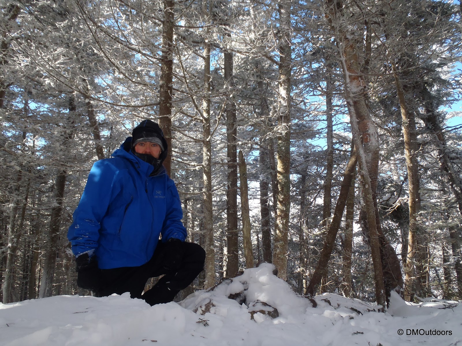
After a solid break taking time to pee, drink water, and check in quickly with family on my status, I was on my way up. Now, being up on the ridge and slightly more exposed, the wind was pretty furious through the trees and above them. All day I had been watching and listening for snapping trees. Because of the wind, it was drastically colder at this point than any other point in the hike. I am not sure whether the broken out trail passed the 1/4 to summit sign or not. It's pretty small anyways, but I never saw it, making it a challenge for me to find the summit cairn. I hiked all of the way until there was no more visible footpath, and at that point, I started to get a little worried that I wouldn't find the cairn. However, luck would have it, that I practically stepped on the cairn as I made my way back south along the ridge. I dug it out a little bit to confirm, and yes! I had reached the summit of Owl's Head - my 35th 4000 footer this winter.
Owl's Head summit in winter
Owl's Head summit - 3rd round, first time in winter
My break here was VERY brief. It was unbearably cold and the wind was sucking any warmth right out of me. It is always a huge relief on a hike like this to know that you will be able to mostly follow your own tracks right out. I was looking forward to that. There was no way in hell I was going down the way I came up, so I passed my entry point onto the path, and continued down to the top of the slide. When I came out at the top of the slide, I was treated to a very beautiful view of Franconia Ridge, particularly Lafayette and Lincoln. The path going down the slide was pretty well broken out, and with careful and slow foot placement, I had no difficulty making my way down. I even carefully did a few butt-slides!
Lafayette and Lincoln from the slide
Owl's Head slide in winter
The junction for the slide as I came through on the way down and out
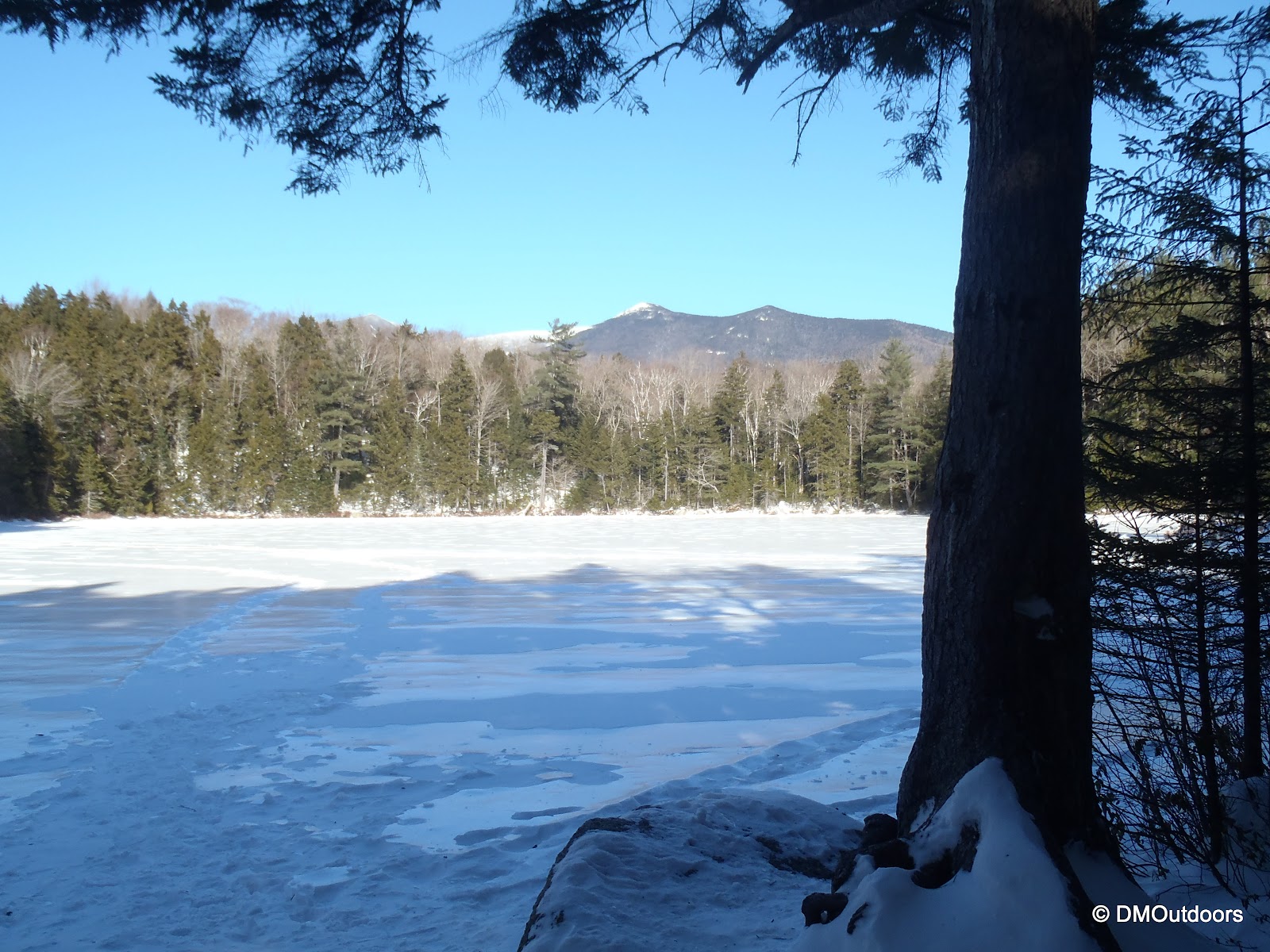
Back on the Lincoln Brook Trail, the consistent wind of the day filled all of my tracks about 3/4 of the way from the time I had been on the mountain. That was pretty amazing, but following the trail was easy. Same went for the Black Pond bushwhack in reverse, where the tracks were less filled in from the winds. I thoroughly enjoyed the hike out where I passed Black Pond again to find a crystal clear view of the Bonds, and also along the Lincoln Woods Trail, the sun shone brightly off the streams, providing me with inspiration to keep hauling to my car. It was a fantastic day, and my first winter ascent of Owl's Head was a great success, which left me feeling really good.
Black Pond bushwhack towards Black Pond
Black Pond
Stream alongside Lincoln Woods Trail
Pemi Bridge at Lincoln Woods
Hike Stats
Trails: Lincoln Woods Trail, Black Pond Trail, Black Pond Bushwhack, Lincoln Brook Trail, bushwhack, Owl's Head Path
Distance: 16 miles (approx.)
Elevation Gain: 2,850 ft.
Actual Book Time: 9:45
On Saturday, my brother, my 8-year old niece, and I were going to take on Mt. Washington. We had been planning it, and each of us, including my niece, were ready both mentally and physically, and we were excited all week long. The weather Friday night was indicating a beautiful day ahead, and as the morning came, there was no question about it. Before we even got to the trail head, the day was exciting.
Driving through Franconia Notch is always beautiful. It could be covered in ominous clouds or be blanketed with the shadows of the mountains across the road from the mountains morning - always stunning.
Cannon cliffs from Route 93
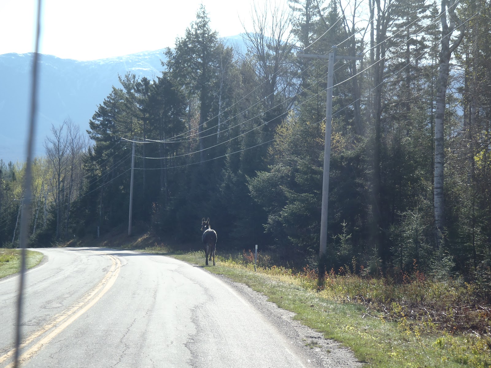
Once we saw Mt. Washington, the excitement grew. On Route 302 after the Irving Station, we came upon a dead moose on the side of the road. It appeared to have been dead, likely hit by a vehicle. There was a stopped vehicle, but it was not damaged. We suspected the driver came across the moose already hit, and was either just reporting it and waiting for authorities, or perhaps they allow passer-bys to claim the road kill? We turned onto Base Station Road on our way to the Ammonoosuc Ravine Trail head. As we were talking about the dead moose, a live one popped out onto the road. It scurried along the right side before trotting into the woods on the left.
Although listed as closed on the Forest Road Status page, the trail head was open and in use. We paid our $3 fee and got ready for the hike.
Mt. Washington from the Ammonoosuc Ravine parking lot
The weather was gorgeous as we set out around 8:30am. The trail was fairly wet, but not obnoxiously muddy. The first couple of stream crossings along the way to Gem Pool were all doable, but not without getting the soles of our boots wet. There are pipes that go along the lower portion of the trail. I assume they are related to the cog, but I am not sure. Anyways, the force of the water from tropical storm Irene had something to say about the pipes. They were bent and wrapped around the trees as shown below. I had hiked on this trail in 2007 and 2010. Now, the area next to the trail and along the river is all opened up now. There is a much wider view up the ravine now from the trail.
First crossing on Ammo Trail requiring attention
Damage from Irene on Ammo Trail
As we continued along, the views were becoming much nicer of the higher peaks above. The wind was picking up a little bit making it chilly at times. We made it to Gem Pool where the sun was beaming so brightly into the open space on the path it was a big warm spot. It was a perfect place to take a nice break. After all, we were going at a great pace with the little one, and we didn't have to take nearly as many breaks as the first 4000 footers she did. We had some water, banana bread, vanilla wafers and energy bars.
Gem Pool and the waterfall was as pretty as I have ever seen it.
Gem Pool
As we got going, there is a stream crossing directly in front of Gem Pool. In the years past it was a trickle, but today, it was just more than a trickle. Unfortunately, things did not go smoothly as we left Gem Pool. With her in the middle of me and my brother, somehow her step did not make it to the next rock, and her foot ended up in a pool of water up to her shins. When she stepped in and attempted to prevent the fall, there was a minor tweak of her knee. We didn't see it 100% so we didn't know whether it was a hyper-extension or not. Afterwards, she could walk ok, but just like many hikers have likely experienced, there were certain steps that would cause a zinging pain for her. We waited a few moments after things calmed down, and we took a closer look, and it was just not going to happen at this point.
It was very sad because she wanted to make the summit so bad. She knew it was the perfect day, and she was crushed. Bill and I were crushed too. But I'll tell you what, we learned a lot from this one about the fact that the mountain will be there another day. As much as we wanted to get to the summit too, we had to be strong for her, make the right decision and help her understand the same. With our decision made, we took another 20 minutes or so hanging out in the sun by Gem Pool. We would try to make the rest of the day as fun as possible. There was no reason to not enjoy being out in the woods on such a beautiful day.
I am not ending this trip report here because we had such a great time the rest of the weekend, and we enjoyed a fantastic Mother's Day. On the way out, we made a quick stop to the Mt. Washington Hotel. If you don't know, the hotel has been featured on the show Ghost Hunters twice now with some pretty cool experiences happening there over the years, particularly with the princess who still lives there. Of course, this intrigues an 8-year old (and me too!). I just as much wanted to see what the inside looked like. We walked in, grabbed a pamphlet and checked out the beautiful lobby (with our muddy hiking boots - oops). The views outside were unbelievable, it truly looks like a world-class resort.
Mt. Washington Hotel with Washington in the background
Mt. Washington Hotel, Bretton Woods
When we got back to Lake Winnisquam, we took my niece to Funspot so we could help add to her stash of saved up tickets for a big prize later this summer. After that, we got back to the camp and enjoyed a great camp fire under the stars. With dad's star mapping app, she had fun checking out the constellations we could see. Our boat was just put into the lake this weekend too, so on Sunday afternoon after a nice lunch and planting Peony and rose bushes for Mom, we all (mom, dad, brother, niece, sister-in-law, and mother-in-law) went out for a beautiful boat ride around Lake Winnisquam. The puffy clouds with sun rays protruding through were just breathtaking. If you like Belknap Mountain, perhaps you've never seen it from Lake Winnisquam. This was an awesome first boat ride of the season.
Belknap Range from Lake Winnisquam (Belknap Mt. is middle)
Looking towards Sanborton from deepest part of Winnisquam
If you want to know what it's like to go for a beautiful afternoon boat ride around Lake Winnisquam, check this out!
All in all, this was no disappointment. Although we did not reach a summit, it was a beautiful weekend, and we came home Sunday night feeling just as happy as if we had reached a summit. My niece saw the doctor already, and has a very minor sprain in her knee. She'll be better with some rest, and we'll be coming back - I know it will not be long before she is asking us to give it another shot.
I think I'm finally done with the long walk of the Lincoln Woods Trail for a while. I feel like I've done it so many times, and in all hours of a day. This time it was my brother's call to Owl's Head as he continues his own quest for 48. With the weather iffy, and patchy fog expected, Owl's Head was the perfect choice for this hike. We left from the Lincoln Woods lot at 7am sharp. The suspension bridge is now closed, so we had to walk over the bridge and around. As we hiked down the 'ol logging road, finding our stride, it was only fitting that we heard the very loud call of an Owl, which rang out from deep in the woods to our left. Perhaps it was telling us a great adventure was ahead.
We hit the Black Pond Trail with a good pace to get to the Pond, anxious to start the bushwhack. Anxious because this is the stuff I go for; something that mixes a hike up and makes it adventure. Hiking into the Pemi Wilderness is an adventure, because its a place with a great sense of remoteness. I hiked to Owl's head and did the Black Pond Bushwhack solo at the break of dawn on July 30th. That time, it wasn't as easy. I hiked too far around the pond before going off on the correct bearing, which led me through some seriously thick stuff. I made out alright that time, just a little bit down river from the crossing. To read that trip report, click here.
I found my way then, but could Bill, leading the way, lead me back to Owl's Head? He sure could, and yesterday, he became a trail master. After a quick break at the magnificent Black Pond, we scooted over the bank and were into the bushwhack. Bill led us along a slightly beaten path, but it faded out quickly. After a while of passing through the open woodlands we hit what appeared to be an old logging road. Game trails were everywhere, and they made for easy travel occasionally. Eventually, we came right onto a pretty distinct path, and we popped right out the at the bootleg campsite by the river crossing. Bill had guided the way perfectly through the bushwhack, and we were in super high spirits. Knowing some common sense map and compass skills can help you out of the woods if you lose the trail or you have to wait for morning. This is the perfect place for a novice hiker to learn because at some point you will cross a trail if you lose the way for real.
We headed up the rocky Lincoln Brook Trail with spectacular scenery with the Lincoln Brook flowing loudly to our right and with yellow and red leaves at our feet. It was so pretty there were a few stops for pictures. Here, we really got the sense that fall is now here, especially in the mountains. Miles from the roads of the White Mountains lies this remote, rugged, but beautiful trail. Eventually after crossing the brook and with it now at our left, we came to the base of the slide. We took a few minute break to have some food and water before the trek up.
After so many miles we were now starting to ascend. This makes Owl's Head unlike any other 4000 footer, as the slide is the only major elevation change. After a few minutes, the path opens up onto the loose gravel and rocks of the slide. The valley was a beautiful shade of yellow and green and the fog was still chopping off the mountain tops. All morning it had been wet, and the majority of the way up the slide was wet rocks making it a challenging ascent. We neared the top, hopping over the dozens of blow downs that litter the path. We passed the quarter mile to the summit sign, and you wouldn't think you have that much to go. Finally, we made it to the summit of Owl's Head. Bill reached his 33rd four thousand footer of the year. For me, it was just another peak off my grid, but this trip turned out to be much greater than just a couple of peakbaggers trying to check off Owl's Head.
After a nice relaxing lunch break on the summit we set off on our descent. Descending the terrain near the top was good going, and we were back out onto the slide quickly. We passed two hikers descending, who asked where we had been. We were at the summit obviously, and they weren't, so they appeared puzzled, but we continued on and descended quickly down the slide. The views opened up slightly to give us the best view of the valley we would get, but still the fog never fully dispersed. We got to the bottom, and we had to filter and re-fill our water in the brook before we got going.
It felt great to be down from the slide, and our legs were good and ready to go for the way out. We moved much more quickly on the way back south on the Lincoln Brook Trail. Again it was beautiful hiking surroundings and we took at all in as we trotted back to the river crossing and the start/end of the bushwhack. Going into the bushwhack the first time in July, I had no clue it was going to come out at such a distinguished area on the trail (bootleg campsite). The fact that Bill was able to lead us directly to that spot was amazing. We headed back up the well beaten path to start the bushwhack back. We started on the way back for several minutes staying on a due south bearing towards Black Pond. We followed the well beaten path a good distance until it became unrecognizable. Eventually, we discovered that we were in a different location than anywhere on the way in. We then started to bear left slightly at about a 160 degree bearing. The terrain became tougher than anything we saw either way. We battled a few tough sections, and then we noticed the terrain was a bit more dramatic, dropping significantly to the left (southwest) and in front of us (south). Looking at the contour lines, Bill put his finger where he thought we were (and we were). We headed through some tough stuff again until we heard running water. We descended on an angle down a steep bank. As we neared the river's edge, an overgrown path became visible. After about 5 to 10 minutes, I pushed through some branches and could see a trail sign just a few feet ahead. It was the sign labeled "End of Trail" for the trail to Franconia Falls. I could not believe that it turned out so perfectly. I was certain that Bill wouldn't go two for two on these bushwhacks, but as the map and compass holder, he mastered the navigational challenge and earned his summit of Owl's Head. We had just took this Owl's Head experience to a different level. There's not much words to explain how awesome it was for this to turn out the way it did.
We went down to the river's edge to take in the majestic Franconia Falls as we talked about what we just accomplished. As we hiked out to the Lincoln Woods Trail, there were more people in the area, but overall, I think the suspension bridge being closed kept many away. We felt great in mind and body until we hit the Lincoln Woods Trail. That's when the feet started to hurt. They always do as soon as you start walking on the flat stuff. Even though it was mid afternoon, the fog was just finally lifting and it gave us a bit of sunshine, brightening the fall colors and again showing us that fall is truly here.
Hike Stats
Trails: Lincoln Woods Trail, Black Pond Trail, Black Pond Bushwhack, Lincoln Brook Trail, Owl's Head Path, Lincoln Brook Trail, bushwhack, Franconia Falls Trail, Lincoln Woods Trail
Distance: 16 mi. (+/-)
Elevation Gain: 2,850 feet
Book Time: 9:50
To view the full album, view or click on the slide show below. This is a good one to view as a slide show.
Here is an edited video of our bushwhack out and back:
What a beautiful day it was to be in the mountains yesterday, but it was also a day with signs here and there that the season is about to change. Me, my brother and his daughter Kiara were on the trail at 7:45am, and we started a Webster-Jackson loop with a twist to attempt to find my lost camera near Jackson. Yesterday was also 9/11, so Flags on the 48 was taking place, and we were excited to be seeing that take place.
It was a chilly 38 degrees as we pulled into Crawford Notch and started up the trail. The beginning of the continued road block on 302E was right next to the parking lot at Crawford Depot. The striking view from Bugle Cliff had us in good spirits motivating us up the trail with the anticipation of greater views to come.
View of Saco Lake and Highland Center from Bugle Cliff
We came to the junction for the two branches of the Webster-Jackson Trail and could hear the waterfall on Silver Cascade Brook roaring just below us. Our route was taking us that way, so we ascended into the steep gully and arrived at in my opinion, one of the prettiest trail side waterfalls I've seen in the White Mountains.
For a short and easy loop on paper, parts of the ascent up to Webster had some steep sections reminiscent of the Garfield Ridge Trail (rocky, rooty, and wet), which kept me happy.
Webster-Jackson Trail to Mt. Webster
When we finally approached the summit, the views were tremendous into Crawford Notch. Kiara was happy to be there and was in awe of how far below and beyond she could see.
View from Mt. Webster
The Webster Cliff Trail between Webster and Jackson was a breeze. Jackson's rocky summit was in our sights as we approached, and it felt like it didn't take long before we were there. Kiara reached her 2nd 4000-footer, and Bill his 33rd. Don't worry, I checked off on a few lists too. The Presidentials loomed over, looking so close, but Washington's summit remained chopped off by the clouds.
Kiara on Mt. Jackson
On a hot first of May, the melting snow and a stray path led me off the trail into thick scrub off the Webster Cliff Trail, and I lost my camera and gorillapod tripod. An attempt to find my camera was unsuccessful. That is because when the snow was melting that day, it was still so deep, and today, the trees were just so thick. I really could not pinpoint any exact path I may have taken, so it would have been a complete miracle, but we made a solid effort getting scratched to heck for over an hour, and we had some lunch in a cool off trail spot where I once stood aggravated as heck and nearly lost.
We trekked back up to the summit of Mt. Jackson where the American flag was erected for the Flags on the 48 event to remember 9/11. Bill and I carried our own American flags on our packs. Although not officially involved in bringing the big flag up to the summit, it was great to be up there to share our remembrance and enjoy a great day in the mountains. There were dozens of hikers of a wide range of ages enjoying the summit and we could see the flag standing on Pierce, which was cool. I chatted with a hiker from Rhode Island who was marveling in the day and event and we shared some hike ideas, wish lists, and some good routes to take along what we could see. He was on the very summit he sat 10 years ago on that day in 2001.
Sharing my personal flag effort with theirs for a Flags on the 48 photo
The wind was whipping pretty good as we descended the steep Jackson Branch off the summit and into the trees. The hike down was long and tough for the little legs, but we made it. Once we did, and we were off in the car, all three of us felt great and thought about the day, well me and Bill did because she was out like a light until we got back to camp. This was a very rewarding trip, and the views were better than I expected. I enjoyed it more because I was so darn aggravated the time I lost my camera. It was an easy, great, and special day.
As always, live life on the edge!
A couple of side notes to this fun trip:
We saw a big moose on 93, many turkeys (in their waning days) on 302, a blue herring on route 3, 2 different caterpillars, a garter snake, gray jays, and many many different colors and kinds of mushrooms.
Not only did we see the the American flag standing on Pierce, but on the way home, as we looked up to the cliffs on Cannon, someone had erected an American flag wayyyy off the summit near the edge of the highest cliff on Cannon...that was pretty sweet, whoever did that is pretty crazy, but worth the effort for the occasion!
Hike Stats
Trails: Webster-Jackson Trail (Webster Branch, Jackson Branch), Webster Cliff Trail
Miles: 6.5
Elevation Gain: 2500
Book Time: 8:15
To view the full album click on the slide show below: