The Deboullie area in the North Maine Woods is such a spectacular place. Its a crazy busy world out there, and to have a place like this to enjoy is a GREAT thing. This was our 3rd time here, and it was just as amazing. Many things happened, and much fun was had, so much so that I could not possibly include everything, but I do promise any trip to this place is going to be special.
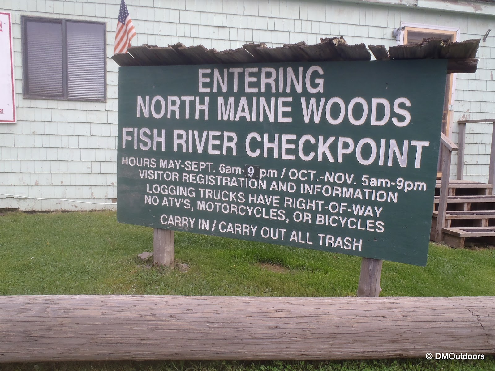
The ride from the MA/NH border is six hours. We left around midnight and were within reach of Portage Lake around 6AM. As we drove on the 60 miles along Route 11, the low clouds and fog covered the road completely at some points and others it was a beautiful display of under cast. We made it to the Fish River checkpoint, which is about 3 miles in on the logging road which starts off of Portage Lake. Here, you must check in, and pay the fee of $20 per person per night, which means that for our group of four, it was $320. Not cheap, but very much worth it for many reasons. The rates are different if you are not staying the night, but its important to know so you bring enough cash.
Low lying fog on Route 11
NMW Fish River Checkpoint
After that, it is close to 30 miles on active logging roads until you reach the Deboullie Pond area. There are mile markers on the roads. Along the way on the logging roads, we saw three moose, two deer, and countless snowshoe hares running around. We arrived at Pushineer Pond and took the road about a mile further to Deboullie Pond where there is another parking area. Since our last trip here in 2010, the area has gone through some upgrades, including a new outhouse at that parking area. We learned from two campers at the boat launch that rangers were at our destination building a new Adirondack style lean-to, and that it would be done today! This was pretty cool, so we unloaded the four kayaks from the jeep and carefully packed them for the paddle across two huge lakes. Off we went, into the great outdoors for 5 days.
Bridge over Pushineer outlet (used to require a fording)
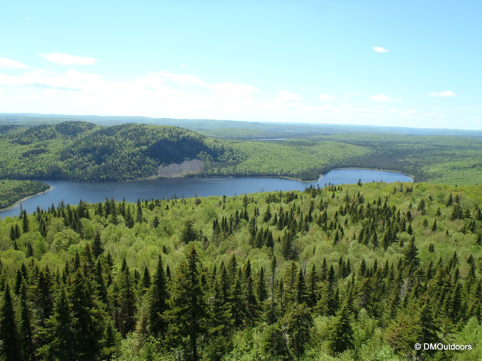
Paddling across Deboullie Pond
We paddled across Deboullie and Gardner Pond and established our camp. The rangers were busy putting the finishing touches on the lean-to, which was built in an area behind the first site that was cleared for it. Afterwards, they used our fire we started to cook some hot dogs and we chatted with them for a while, which was really cool. These guys love the outdoors so much too, they really have an awesome job. They filled us in on the exact locations of the ice caves in the area, and we talked about our prior experiences in the Deboullie area. After completing their work, they left, and waiting for us was a brand new lean-to that had never been slept in. Our good friend Sean was the first to ever sleep in it, and me and Bill slept in it one night of the three we were at Gardner. When we come back here again...sometime in our lifetime, it will be totally awesome to think back on the first time this shelter was ever used. I hope that is there for many years to come. By the way, they built another one at Gardner East too.
Gardner Mountain rock slide on the way across Gardner Pond
Our tent setup (new shelter in back)
The brand new Adirondack style lean-to at Gardner Point
Over five days and four nights, a lot happens, including sometimes a whole lot of nothing, and a whole lot of no biting fish, and a whole lot of food preparation. Rather than go on about every exact thing we did and when we did it, I will break it down a bit differently for this report by activity. Continue on...
Paddling
At this time, the Gardner Point campsite is accessed only by kayak, however that will soon change, as a trail is planned to loop Gardner Pond and connect with the other current trails. To get to our site, we had to kayak across Deboullie Pond, portage our kayaks to Gardner, and then cross that pond. On our last day, most of us traversed Pushineer Pond too. Over the entire weekend, winds never allowed the water to be completely still like it was in 2010. These lakes offer some challenging kayaking. Paddling across Gardner Pond from Deboullie is always difficult because of the westerly winds, which blow whitecaps right in your face. Not to mention that, you can't stop paddling or turn to the side or risk getting worn out trying to start again or be toppled by a large wave. While paddling here, your a very small person on a vast lake miles from any civilization.
Paddling across Deboullie Pond
Sean is seen below paddling to camp ahead of us on Gardner
Choppy water on Gardner Pond
Hiking/Climbing
On Friday, we explored the rockslide on Gardner Mountain. The pictures do not even do any justice to how massive it is up close and in person. We would have liked to summit, but we might have to wait until the trails are built because there was no way around or up from the rockslide.
The areas of vegetation are thick and tough to pass through, and the shoreline is all rocks and the depth of the lake is easily 30 feet at least at the edge...like stepping off the deep end. Finding a suitable spot to pull the kayak up in this area is not easy. If you can climb up at least halfway though, you will be greatly rewarded with a view not many people have ever seen.
View down from near the top of the rock slide
Looking straight up from as far as we could go up
Close up of the slide and sheer cliffs above
On Saturday, me and Bill hiked to Deboullie Mountain while Sean and Eric stayed back around camp fishing and paddling. Trails originate near Pushineer Pond and circumnavigate Deboullie Pond. After we kayaked across Gardner, we left the kayaks and hiked towards Deboullie Mountain on the trail. Along the way, there were a couple of pretty large blow downs across the trail. Bill and I thought it was a cool idea to pitch in a couple of extra minutes and clear a a couple of good blow downs. We were very excited this opportunity was right in front of us, especially to give back to those who already maintain this area for us to enjoy.
One of two blow downs we cleared on the way to Deboullie Mountain
The hike up to the mountain is a short but steep climb of about 800 ft of elevation to the summit, which offers tremendous remote views with no civilization in sight. The sun was beaming hot, it was a beautiful day, and the trail was very pretty. It was suggested by someone in the area that we visit the inside of the fire tower on the summit since we had not climbed up it before. Boy did we miss out those prior years. As a matter of fact, while climbing down from the tower, we noticed the USGS summit benchmark for the first time directly beneath the tower. The views extended well beyond 100 miles because we could see Mt. Katahdin about 75 miles away. We could see as far as the eye could see, basically.
Trail to Deboullie Mountain
Standing at the trail junction and start of the climb
From left to right, Black Pond, Deboullie Pond, and Pushineer Pond
Mt. Katahdin from Deboullie Mountain fire tower
We also took a late afternoon bushwhack from the campsite up and around towards the more gentle sloping side of Gardner. We walked quietly through the woods hoping to see a moose or signs of wildlife. We saw several different types of poopies throughout the entire trip (you can see them in the album below). We kept moving forward, and even this way we came to an abrupt end at a massive rock wall. We were quite surprised and humbled that it was so difficult to pass over or approach the summit from this side. It makes it so much more remote and real. There's no easy access to this spot, which is why we love it so much. (the photo below was taken with my GoPro so it has a fish-eye effect on the trees, but you get the idea - cool bushwhacking)
Exporing the woods near Gardner Mountain
Wildlife & Fishing
Wildlife we saw: Deer, Moose, Snowshoe hare, red squirrel, garter snake, beaver, loons, ruby-throated humming birds, blue jays, toads, crayfish, arctic char, yellow perch, a newly hatched dragonfly
Wildlife we heard: Owls (every night), woodpecker (we knew which tree, but could not see him, he had to be huge)
The fish were not as big as the two we caught last year. This makes that nice catch in 2010 really special. Sean had success pulling in multiple arctic char ranging from 6-9 inches, but only one was kept and eaten on the whole weekend. We each had at least one catch. My best of about three small char was pregnant. There were a couple of days and at certain times there is just no bites at all. I make it sound easy, but I have well over an hour of video from the weekend of me just casting and catching nothing. We fished in Gardner, Deboullie, and Pushineer Ponds, and all catches were in Gardner, but this time they were all very small - This is a good sign, though, for the rare char.
How cool is this guy?
The Rest of the Trip
For our last night, we paddled back to Pushineer South to get an early morning start home on Monday. Although it was overcast and cloudy most of the afternoon and evening, it was still comfortable. With the tent pitched right over the pond, we left the rain fly open on one side. Bill and I kayaked down to Fish Pond earlier in the evening, which is the small pond that Pushineer drains into. Its no more than a few feet deep, and we didn't see any fish jumping, but it was a cool little abode, and worth the 20 minutes excursion from base camp. We enjoyed a nice fire at Pushineer South, but the wood was tough burning, we had to feed the fire constantly. It worked out though, and we had some more Glenlivet to toast on another wonderful trip to this beautiful place.
Pushineer South campsite
A beaver swims right past the campsite
My kayak and Pushineer Pond
Please click on the slide show below to see a lot more photos from the trip - I've captioned most of these since most are not familiar with the area. I took over 1000 photos and 105 videos on this trip, that means almost 800 didn't make the cut for my online album. I plan to put together a video, but I'm afraid it will be while with my upcoming trip. I have video of me catching the pregnant char, paddling across white caps, climbing the Deboullie tower....and much much more, but you'll see those in a video sometime soon or when I have the chance. If anyone has any questions about the area, feel free to ask here.
On Saturday, my brother, my 8-year old niece, and I were going to take on Mt. Washington. We had been planning it, and each of us, including my niece, were ready both mentally and physically, and we were excited all week long. The weather Friday night was indicating a beautiful day ahead, and as the morning came, there was no question about it. Before we even got to the trail head, the day was exciting.
Driving through Franconia Notch is always beautiful. It could be covered in ominous clouds or be blanketed with the shadows of the mountains across the road from the mountains morning - always stunning.
Cannon cliffs from Route 93
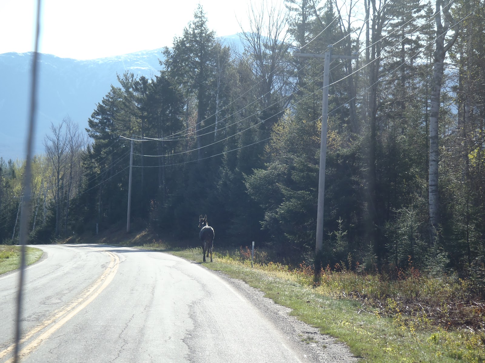
Once we saw Mt. Washington, the excitement grew. On Route 302 after the Irving Station, we came upon a dead moose on the side of the road. It appeared to have been dead, likely hit by a vehicle. There was a stopped vehicle, but it was not damaged. We suspected the driver came across the moose already hit, and was either just reporting it and waiting for authorities, or perhaps they allow passer-bys to claim the road kill? We turned onto Base Station Road on our way to the Ammonoosuc Ravine Trail head. As we were talking about the dead moose, a live one popped out onto the road. It scurried along the right side before trotting into the woods on the left.
Although listed as closed on the Forest Road Status page, the trail head was open and in use. We paid our $3 fee and got ready for the hike.
Mt. Washington from the Ammonoosuc Ravine parking lot
The weather was gorgeous as we set out around 8:30am. The trail was fairly wet, but not obnoxiously muddy. The first couple of stream crossings along the way to Gem Pool were all doable, but not without getting the soles of our boots wet. There are pipes that go along the lower portion of the trail. I assume they are related to the cog, but I am not sure. Anyways, the force of the water from tropical storm Irene had something to say about the pipes. They were bent and wrapped around the trees as shown below. I had hiked on this trail in 2007 and 2010. Now, the area next to the trail and along the river is all opened up now. There is a much wider view up the ravine now from the trail.
First crossing on Ammo Trail requiring attention
Damage from Irene on Ammo Trail
As we continued along, the views were becoming much nicer of the higher peaks above. The wind was picking up a little bit making it chilly at times. We made it to Gem Pool where the sun was beaming so brightly into the open space on the path it was a big warm spot. It was a perfect place to take a nice break. After all, we were going at a great pace with the little one, and we didn't have to take nearly as many breaks as the first 4000 footers she did. We had some water, banana bread, vanilla wafers and energy bars.
Gem Pool and the waterfall was as pretty as I have ever seen it.
Gem Pool
As we got going, there is a stream crossing directly in front of Gem Pool. In the years past it was a trickle, but today, it was just more than a trickle. Unfortunately, things did not go smoothly as we left Gem Pool. With her in the middle of me and my brother, somehow her step did not make it to the next rock, and her foot ended up in a pool of water up to her shins. When she stepped in and attempted to prevent the fall, there was a minor tweak of her knee. We didn't see it 100% so we didn't know whether it was a hyper-extension or not. Afterwards, she could walk ok, but just like many hikers have likely experienced, there were certain steps that would cause a zinging pain for her. We waited a few moments after things calmed down, and we took a closer look, and it was just not going to happen at this point.
It was very sad because she wanted to make the summit so bad. She knew it was the perfect day, and she was crushed. Bill and I were crushed too. But I'll tell you what, we learned a lot from this one about the fact that the mountain will be there another day. As much as we wanted to get to the summit too, we had to be strong for her, make the right decision and help her understand the same. With our decision made, we took another 20 minutes or so hanging out in the sun by Gem Pool. We would try to make the rest of the day as fun as possible. There was no reason to not enjoy being out in the woods on such a beautiful day.
I am not ending this trip report here because we had such a great time the rest of the weekend, and we enjoyed a fantastic Mother's Day. On the way out, we made a quick stop to the Mt. Washington Hotel. If you don't know, the hotel has been featured on the show Ghost Hunters twice now with some pretty cool experiences happening there over the years, particularly with the princess who still lives there. Of course, this intrigues an 8-year old (and me too!). I just as much wanted to see what the inside looked like. We walked in, grabbed a pamphlet and checked out the beautiful lobby (with our muddy hiking boots - oops). The views outside were unbelievable, it truly looks like a world-class resort.
Mt. Washington Hotel with Washington in the background
Mt. Washington Hotel, Bretton Woods
When we got back to Lake Winnisquam, we took my niece to Funspot so we could help add to her stash of saved up tickets for a big prize later this summer. After that, we got back to the camp and enjoyed a great camp fire under the stars. With dad's star mapping app, she had fun checking out the constellations we could see. Our boat was just put into the lake this weekend too, so on Sunday afternoon after a nice lunch and planting Peony and rose bushes for Mom, we all (mom, dad, brother, niece, sister-in-law, and mother-in-law) went out for a beautiful boat ride around Lake Winnisquam. The puffy clouds with sun rays protruding through were just breathtaking. If you like Belknap Mountain, perhaps you've never seen it from Lake Winnisquam. This was an awesome first boat ride of the season.
Belknap Range from Lake Winnisquam (Belknap Mt. is middle)
Looking towards Sanborton from deepest part of Winnisquam
If you want to know what it's like to go for a beautiful afternoon boat ride around Lake Winnisquam, check this out!
All in all, this was no disappointment. Although we did not reach a summit, it was a beautiful weekend, and we came home Sunday night feeling just as happy as if we had reached a summit. My niece saw the doctor already, and has a very minor sprain in her knee. She'll be better with some rest, and we'll be coming back - I know it will not be long before she is asking us to give it another shot.
We are now 48 days away from our attempt to summit Mt. Whitney. Just about every single day, I add something to my planning sheet for this adventure. Over the last several weeks, and after continuing to read up on everything I can, I have compiled a pretty-close-to-final itinerary for our entire trip.
Since I posted Chapter 2, we have purchased trail maps and a couple of books on Mt. Whitney. We have confirmed our flights, and will be flying both ways together. This entire plan can change slightly, and I expect it will on the go, but its now mostly set. If you have hiked Mt. Whitney, or even if you haven't, I welcome any suggestions that anyone may have or other ideas for consideration. As you will seem we actually have 2 nights to spend in the Whitney area, and maybe a third, so we're looking at other ways to maximize our adventure!
Itinerary: Part One - Getting Out West and into the Sierras Wednesday, June 13 - Sunday, June 17
Take flight from Boston to Las Vegas on 6/13/12. Flight departs Boston in the early evening lands in Las Vegas after 11pm. (There will be several of my friends from HS on this flight too)
Check in to my hotel on the strip and confirm receipt of my shipped gear (stove, knives, etc), and immediately start partying!
Attend wedding festivities Wednesday-Friday, and attend my friend’s wedding Friday evening in Las Vegas.
Pick up rental car from Las Vegas on Saturday Afternoon.
Depart Las Vegas by 7:00am Sunday and drive 234 miles, approximately 4hrs 20min to Eastern Sierra Interagency Visitor Center in Lone Pine, CA.
Pick up the official wilderness permit at Eastern Sierra Interagency Visitor Center. (Tentative pick-up time is around noon-time. (If, in the event we arrive after 5pm, there is a night box under a gazebo to the left and behind the building, we must contact them in advance)
Ask about snow cover, trail conditions, and upcoming weather conditions
Inquire about bear canister rental.
Pick up any other last minute personal items, hiking items, or luxury-type food before leaving Lone Pine. If we want to have a campfire at Horseshoe Meadow, purchase our own firewood.
Follow driving directions from Lone Pine to Horseshoe Meadow Road (left off Whitney Portal Rd), and drive to the walk-in campgrounds located at Horseshoe Meadow, 10,000’.
Establish a campsite location, lock up our food, and focus on having a great evening resting, preparing, and acclimating. If time allows, take a short hike to exceed 10,000 feet, if possible.
Itinerary: Part Two - The Mt. Whitney Adventure - Day 1 Monday, June 18, 2012
Wake around 6:00AM at Horseshoe Meadow, pack up the campsite, and begin our drive to Whitney Portal.
At Whitney Portal, scope out the store, grab a bite to eat, ask of any updated trail conditions, or weather conditions, and both of us will perform a thorough and final gear check.
Leave Whitney Portal on Mt. Whitney Trail at approximately 9:00am, no later.
At 2.8 miles, take a short break at Lone Pine Lake at 9,900’ for pictures and to drink water.
Hike 1 mile, and at 3.8 miles, take a break at Outpost Camp at 10,300’ for more pictures and water. Refill water here if necessary, and it must be treated. (If weather is questionable, establish camp and re-align the itinerary for day two.)
At 4 miles, stop to photograph Mirror Lake and the meadows below. This is treeline.
At 5 miles, stop at Trailside Meadow for a break if needed for water and to take photos.
At 6 miles, arrive and establish camp at Trail Camp, 12,000’. Should we have about 2 hrs of free time and no symptoms of AMS, we could explore trail camp.
Take it all in spending the evening and camping out at 12,000’ - get everything ready for morning, and get as much sleep as possible, but not too much.
Itinerary: Part Two - The Mt. Whitney Adventure - Day 2 (Summit Day) Tuesday, June 19, 2012
Wake around 2:30am, eat breakfast, and plan to leave camp no later than 3:30am. The plan is to allow 4 hours to reach the summit, and be approaching Trail Crest around sunrise.
At 8.2 miles, and after the 99 switchbacks, arrive at Trail Crest 13,700’ and take a break to take in the views. Look for Mt. Hitchcock, Hitchcock Lake, and Guitar Lake, and more.
At 11 miles, arrive at the summit of Mt. Whitney. Depending on conditions, we will enjoy the summit for 1 hour.
Sign the summit register.
At the summit, look for the city of Lone Pine, Owen’s Valley, Mt. Russel, Langley, Muir, and the Sequoia, Inyo, and White Mountain Ranges.
After we’re done at the summit, we begin our descent.
(Optional - good conditions only) On the descent, look for the Mt. Muir turnoff (unmarked) near the John Muir Trail junction. - Climb the class III scramble to Mt. Muir (14,015ft) and return to junction. Mt. Muir is a CA 14,000-footer.
Enjoy the rest of the afternoon in the Sierras, and hike continuously down and out to Whitney Portal. Stop at Whitney Portal Store for some food and souvenirs. Drive to the Eastern Sierra Interagency Visitor Center to return the rented bear canister.
Check into motel on Tuesday afternoon to rest and leave for Vegas the next morning. (I can recommend the Dow Villa Motel).
On Wednesday morning, leave Lone Pine and
Drive approximately 234 miles, approximately 4hrs 20 min back to Las Vegas. (With an evening flight, we left early enough to be able to explore most of Death Valley on the way back to Vegas)
Leave Las Vegas for Boston on the red-eye.
That's how I plan to hike Mt. Whitney. At this point, the only thing that needs to be reserved is the rental car, and the only thing left to do really is buy a few more gear items, finalize the pack lists, and do a test overnight hike with all of the gear we intend to bring. Bill and I are crafting that test hike right now (in addition to other planned hikes) for the one of the first two weekends in June, and it will be another unique one, which may include Mt. Washington, Mt. Isolation and several other mountains with spectacular views. It only gets more exciting from here, and there is so much more to come from DMOutdoors this summer!