Friday, September 28, 2012

Inside The Moments: Episode 2 - Catching Maine's Rare Arctic Charr

In 2010, it was the year of fishing and kayaking for me, and there was somewhat of a reason for that which I will leave personal, but it was fun, and I had a lot of quiet time during these outings. All summer long I had fished, but when it was May and my brother's birthday, there was no forgetting our next, and 2nd Deboullie trip, for which I crafted into a kayak AND camping trip.


During this 2nd adventure to Deboullie, I had the most memorable fish-catch of my life to date. It was no twenty-pounder or anything, but I had caught Maine's rare Arctic Charr, also known as a Blueback Trout.

During our first trip here in 2009, we had not one bite and didn't get to eat any fish. This time would be different. While fishing from in the water along the shore of Gardner Pond from the Gardner West campsite, we were not getting any bites. (I could show you this from the many dozens of minutes of footage I have before I caught my fish.) Constantly checking our legs for leeches, we fished for a long time that afternoon, with my brother about 20 feet next to me. If you read about catching the Charr, you'll learn that the species likes the deep, cold water found in the drop-offs, which are predominantly found along the shores of Deboullie and Gardner Ponds, as the steep mountains dip right into the depths of the lakes.
Gardner Pond
After a long time of no action or bites, I decided to take a few steps further out in the water so that I could cast my line as far as possible. In addition to that, I let it sink for several seconds before clicking the line in. Just seconds after that, I was startled by a fierce tug on my line. I thought you have to be kidding me?! After hours of fishing, I make a couple of specific and thought out adjustments to my casting and location, and BANG. Of course it felt like a giant had struck my line, but really it was regular sized fish with a decent amount of fight that had jumped out of the water in front of me. It would be either a brookie or Charr, and when I reeled it home, sure enough it was my first Charr. I remember being so excited it looked like I was catching a fish for the first time!

Here is the video of the moment. (Fast forward to about 4:30 to go right to the action.)


Now.....Going back to before my catch, our friend Eric caught a slightly larger one than mine the night prior, so before I even caught my own, I had witnessed a catch and had tasted the Arctic Charr. The process of getting it from the rod to the fire and into our bellies can be seen below.


As you can see, we cooked that baby up nice and it was just awesome. The fish was so delicious, I could hardly describe it. We mixed some of the fish with a can of Chunky spicy gumbo soup, and that too was simply amazing. As I ate my fish, I had no idea what would come in the middle of the night....
Arctic Charr and Gumbo
Apparently, I am allergic to fish in the salmon/trout family... I went to bed hoping for a good night's sleep, but what happened was the most disgusting and crappy night ever out in the woods to this day. I barfed and screamed all night long until the sun came up and by that time, the only thing that was coming out of my stomach was bile. How was that fish so good, and how could that happen? I guess this will go down in history as the only time ever that I will eat this fish. This is a reason it remains all so awesome for me.

After our few days camping, we paddled out across the deep glacial lakes, and the people camping closer to the parking areas were shocked that we had stories of the Charr. They wanted to know everything about how we caught it. People come from far away to catch the elusive Blueback in Maine. This species is only known to be in 12 lakes in the State of Maine, according to the Maine Department of Inland Fisheries & Wildlife (sometimes its 11, sometimes its 12, depending on what you read). Those waters are listed in the management plan link below. The fish are tough to catch because they like the bottom of the lakes where it is cold, but in addition to that, the bodies of water are simply difficult to get to. This is why catching an Arctic Charr of any size can be considered a life-time catch. Although we caught a few, we only kept and ate two that weekend.

I visited Deboullie again in 2012, and remember catching a tiny blueback, and the rest of us had similar action, and nothing close to worthy of keeping for a meal. Given that my brother and I didn't get one single bite in 2009, this goes to show you that your trip here may or may not result in pulling a Charr for your meal.

Visit Maine's Department of Inland Fisheries & Wildlife page here for brief stats on the species.
To read about the largest Arctic Charr ever caught in Maine, read this article here.
The 2001 Arctic Charr management plan can be read here This PDF file contains very good information on the fish and its presence in Maine.

If you have any questions or comments about or experiences catching the Arctic Charr, feel free to leave a comment!

Friday, September 21, 2012

Inside The Moments: Episode 1 - First Time To Deboullie

In August of 2009, I was a complete rookie when it came to hiking, camping, and outdoor adventure. I had done some pretty cool stuff already like paddled most of the Ipswich River, climbed to Mt. Washington, and did some other cool things, but my first trip to Deboullie in Aroostook County, Maine was what really got me going when it comes to going on outdoor adventures. (Photo: taken from Deboullie Loop trail as it crosses the rock slide.)

I had never done any remote camping or hiking before really, but here I was having dragged my brother to this weekend hike to check out this remote place in Maine. On this trip, we dove right into hiking at night, trying to choose a tent-site, navigate a lightly traveled hiking path, and in general just being far away from home and emergency services.

During the Saturday on that weekend, which was basically our one full day on this first trip to this magical place, we got that feeling of "remote" that we were looking for, no question about it. From our campsite on Deboullie Pond, all I remember is taking a walk down this trail and it opening up to another enormous body of water, Gardner Pond. Back then, we wondered what was on the other side. Then we hiked to Galilee Pond, where we saw this picturesque little pond, with driftwood sunken along its rugged and thick shores, and sheer cliffs above it on the other side. Later that evening, after we cooked dinner back at our campsite, we went back down the trail to Gardner Pond and the sunset we saw was one of the first memorable sunsets I can recall experiencing in the outdoors. It remains one the most memorable ones simply because of the magnitude of the place, the remoteness, and then my inexperience; yet maybe it could have been the moment I realized that I really enjoyed doing this stuff.
Gaililee Pond, Maine 
Sunset over Gardner Pond
Look at us and our enormous packs! What the hell were we thinking ever carrying that much shit into the woods for an overnight?!


Deboullie gave me a sense of what it was like to adventure out into true wilderness, and looking back this first experience, it had a little bit of everything I continue to enjoy today: sunsets, wildlife, camping, hiking, night-hiking, and being in a remote location. In addition to that, it also proved that I could go out and craft my own adventures. Although we didn't get to stay more than one night, and about two days on this first trip, it was decided before we even left that we were coming back, and we have two more times since! Stayed tuned because there are definitely more moments to relive from Deboullie!

Go back to this hike's album


Monday, September 17, 2012

The Tripyramid's, Sleepers, & Whiteface - 9/16/2012

It was another awesome day in the White Mountains on Sunday - perfect for a White Mountain 48 finish for my friend Mike, and a hike I had been looking forward to for a while, the Sleepers Peaks. On top of those two factors, there would be more to make this a unique adventure. My brother and niece were going to hike up Whiteface from Ferncroft and meet us on the summit! So, this one is a little different. This was the first time my brother's hiked a peak with out me! Truly a unique and awesome day...here we go! (Above photo is the view from the South Slide of Tripyramid)

With 45 done, three 4000 footers remained for my friend Mike, who writes and has been shaping up his blog, The Outhouse. The plan was a traverse of the Sandwich Range from Pine Bend Brook Trail, to Whiteface and to Ferncroft, where we would get a ride back from my brother. We started our hike at 8am sharp, and we were blitzing up the Pine Bend Brook. In fact, at the end of the Pine Bend Brook Trail, we noticed we just did it at 3.2mph. What a great start and beautiful trail.
Pine Bend Brook Trail head on Kancamagus Hwy 
First unobstructed view back on the way up Pine Bend Brook Trail
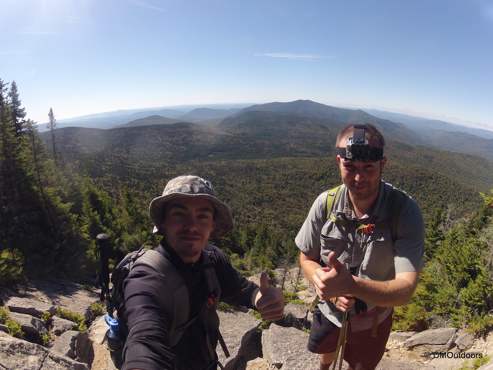
We arrived to a vacant, North Tripyramid summit. It was cool, crisp, and the air was feeling like fall. The sun rays coming through the trees provided sporadic warmth when not moving. North Tripyramid was my 21st summit of my 3rd round of the 48, and it was Mike's 46th peak.


While the Tripyramid's may not be on many peakbaggers' favorites list, this entire area in the Sandwhich Wilderness has some of the prettiest trails I see. If you enjoy beautiful scenery just as much as peakbagging, the Tripyramid's deserve a bump up your to-do list. Not before long we were on Middle Tripyramid, taking in the pretty nice views that the summit offers. Mt. Tecumseh and Waterville Valley are seen to the Northwest, and Chocura is seen in the near distance in the view east. This called for a decent break, and that we did. Middle Tripyramid was my Trailwright 72 peak on this hike, which completes the peaks in the Sandwich Wilderness for that list. More importantly, it was Mike's 47th peak, and with that only a few miles stood in the way of the completion of his journey to 48.
Mt. Chocura, from Middle Tripyramid summit 
Middle Tripyramid summit 
South Tripyramid summit
We made it to South Tripyramid where we stopped briefly for photos, but we continued on quickly, descending the tricky trail down to the top of the slide. The view from the slide was tremendous, and one of the highlights of the day to come out onto it. The Kate Sleeper Trail was just down to the left. A cairn in the middle of the slide is a good indicator, but the Kate Sleeper sign is small and dark, so not necessarily visible right of the bat. We took a last glimpse of the view before diverging left.
South Tripyramid slide 
Kate Sleeper Trail sign 
Thumbs up - 3.3 miles to Mike's 48 
Still some slide to contend with on Kate Sleeper Trail
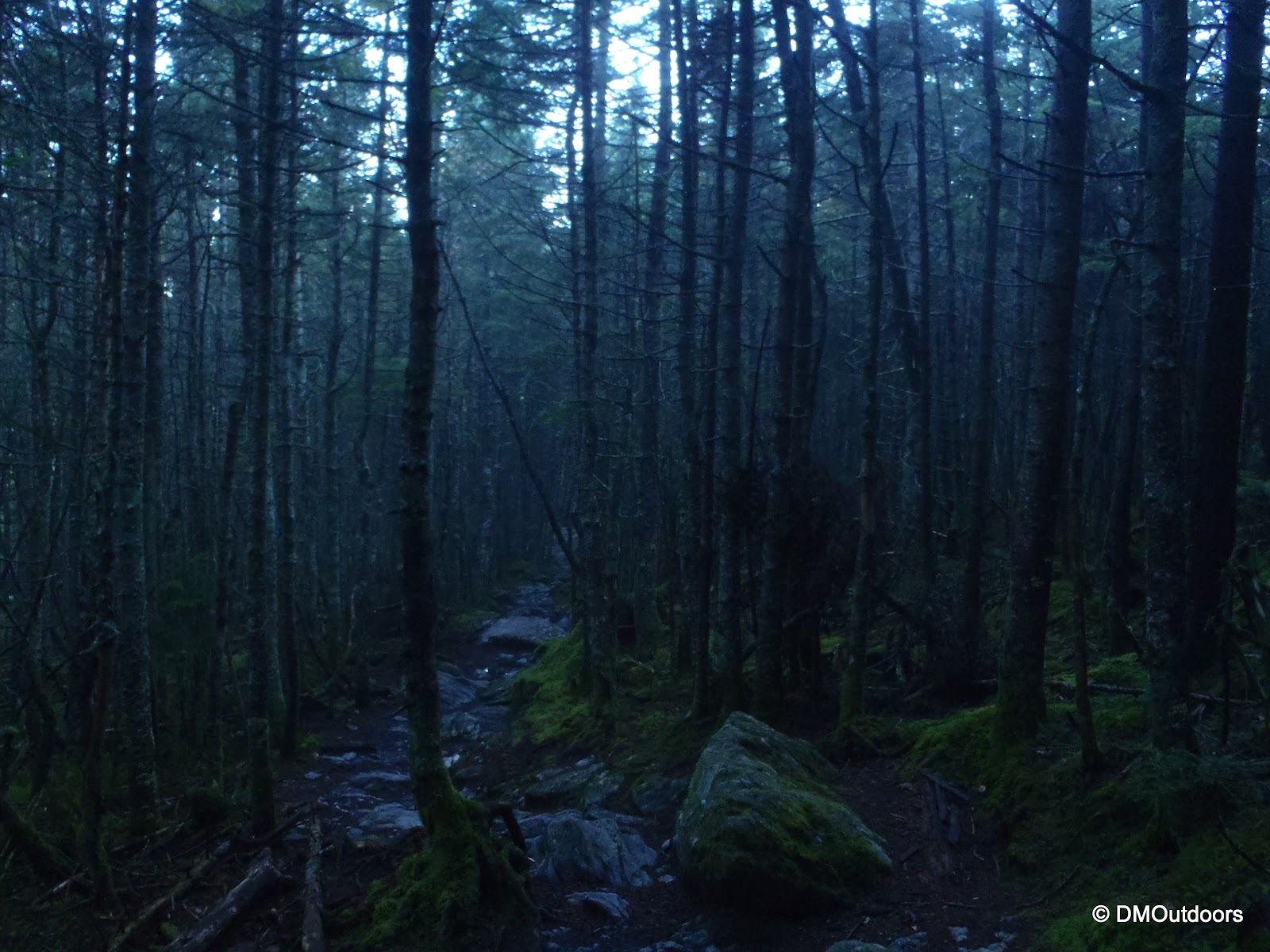
As we started on the Kate Sleeper, we thought we'd be in the tress for the rest of the way, but there was another slide section to cross, and THEN into the trees, where, for a short distance, the trail hugs the steep slope until it fattens out. From this point, the Kate Sleeper Trail was everything I though it would be, just as nice of a trail as the Tripyramid Trail and Rollins - just awesome woods! Following the map and contours closely, we approached the approximate area for the summit of West Sleeper. There were a couple of very lightly tread paths leading left off the trail, which we followed to a seemingly well-beaten circle patch that felt like the summit. A GPS-mapping app put the summit within just a few feet, so we were there - West Sleeper - pretty cool. This peak is found on the NH 100 highest list.
The Sleepers, West Peak summit
Continuing on the beautiful trail, we came to a sharp turn left shown on the map, and then shortly after, a sign for the spur to East Sleeper. This was a cool moment, because East Sleeper has been on my to-do for a while now, on the NE 100 highest list. The "short" spur path seemed rather long (sort of like Zealand feels like a long .1!), but finally we made it to the marked summit.
The Sleepers, East Peak - New England 100 Highest Peak
Now, with 5 named peaks done and in the bag, the excitement grew as Mike's finish grew near, now only a little over a mile away. We took a solid break at the Downes Brook Trail junction, which I might add was a beautiful spot in the middle of the woods with moss covered rocks and lots of greenery. Snickers and snacks in us, we were now less than a mile away from the finish. The ascent from Downes Brook Trail to Whiteface is gradual, but very pleasant. We reached the Rollins Trail and went left.

At this point, we were keeping an eye out for my brother and niece. We were able to exchange texts as we were at Downes Brook, so I knew they had reached the summit already from the Blueberry Ledge Trail, and would be up there somewhere. As we neared the summit, we came across them hanging out waiting for us. How cool is this? Bill and his daughter, just hangin' and napping above 4000 feet.
Hangin' in the trees, waiting for us on Mt. Whiteface
After a quick moment for them to wake up and pack the hammock, we all joined Mike as he took his last steps to the summit of Whiteface and completed the 48 Four Thousand Footers. Quickly, we were in celebration mode, busting out a few ice-cold beers (and apple juice), and then some sips of Scotch and Whiskey! It was a whole bunch of fun, and it was so cool to have my niece witness someone finishing the 48, because the more we hike, the more she wants to do them all.
Mike's 48th and final peak 
Cheers, Mike, to a successful completion of an incredible journey 

Man oh man. After the celebration, came the toughest decision of the day - should we bag Passaconaway? The decision was yes for about 15 minutes, but then it was no, then yes, but then ultimately no, as we decided to descend the Blueberry Ledge Trail together as planned. Mike got Passaconaway last weekend, but had to abort his finish due to rain. I would have liked to get it, but one of the main reasons I gave in was so that Mike would see and experience the views of Whiteface, his final peak. So that was that, we were all on our way down together, as planned, on the Blueberry Ledge Trail. This would turn out to the best idea, as you will see why from the photos below.


Mt. Washington & Presidentials from Whiteface ledges 

Kiara's 4th NH 4000 footer, and 5th in New England! 

Ferncroft area as seen from the ledges 
Descending a portion of the ledges 
Consumed wholly by the summit celebration and difficult decision we were involved in, I forgot that I had a surprise gift (until Mike reminded me by talking about getting his patch!). Most who reach their 48th peak will wait until they get their patch from their submitted application to the AMC, however as we breaked by the Blueberry Ledge Trail cut-off, I took the opportunity to once again congratulate Mike on his completion and I presented him with a surprise official AMC 4000 footer patch.
Presenting Mike with an official patch for completing the 4000 footers 
Completely surprised! 


After the continued celebration and further enjoyment of the remaining ledges, we descended into the trees and down to Ferncroft, where the iconic view of Whiteface and Passaconaway behind the farm was matched with a picture-perfect blue sky. I truly enjoyed this hike for one particular reason, and that was because of the amount of experiences that were talked about along the way. Both of us reminisced on some of the best moments we each had while hiking the 48, including a couple of hikes together. Bill even had his own memories to share on the way down. More people are hiking the 4000 footers of the White Mountains these days, but one thing will always remain true, and it is that the journey is never the same from person to person. The peaks can be done in just days, years, or for some, a entire life time. The route taken is never the same. The elements change by the hours up here, thus making each day, each peak, a different experience for everyone. If you are thinking about the hiking the 48, don't think of it as a list. but a journey, because whether done in a year or a life-time, it will always be a lifetime experience that remains fresh in your memory every day.

Congratulations to Mike on completing his 48! Mike's blog is The Outhouse. He just switched his older blog over to Wordpress and is the process of making updates. If you're looking for another blog for hiking or climbing trip reports and photos, feel free to check it out. He is on Facebook too!  Happy Peakbagging!

Hike Stats
Trails: Pine Bend Brook, Kate Sleeper, Rollins
Distance: 12 miles (Pine Bend Brook to Whiteface Summit, and to Ferncroft) (Blueberry Ledge Trail to Whiteface and back is 8.4mi round trip)
Elevation Gain: 3,250 ft (traverse)
Book Time: 8hrs 40min

Wednesday, September 12, 2012

Vermont's Five 4000 Footers in Two Days

What an incredible weekend it was in Vermont as my brother and I took on and successfully climbed Vermont's five 4000 footers in two days. Since we had never hiked a single step in Vermont before, there was a great sense of uncertainty and unknown factors as we planned out the logistics for this undertaking. At the same time there was great excitement and of course NO doubt in our minds that this would be a mentally and physically tough challenge, Two separate hikes, two days in a row, on trails we knew only stats about.

In terms of the plans and routes, we considered a couple of different options for the 5 peaks, but everything leaned towards going North to South (Mansfield to Killington), doing the two short hikes first and the two longer hikes second. Each of the peaks had about an hour drive (one of them a little more) between them, and this seemed to be the most logical way, in terms of keeping driving time and distance to a minimum. One of the options we left for ourselves was that there might even be an opportunity to start the 3rd hike (Abe & Ellen) on the first day, and hammock camp or use Battell Shelter on the way up Abraham on the Long Trail. In planning, we banked on ourselves being able to meet the stated book times on each hike (the map we had and online research), but we did factor about 3 hours or so of leeway on each day in our planning. This was not much to leave ourselves, but then again hiking 5 mountains across an entire state in two days does not leave one with much time to begin with :)

We left MA on Friday night between nine and ten o'clock at night, and we arrived at the Long Trail South trail head for Mt. Mansfield on Route 108. It was so dark, and we were mesmerized by the coolness of the mountain road, that it took a few minutes to find the exact trail head. The signs are somewhat set back from the street, so we actually drove past it, but then checked out each one until we found the right one. This was good because we became acquainted with the map. The road climbs steeply near the trail heads, and huge boulders come within inches of the side mirrors. We parked, put the seats back, and got some rest/sleep.

By the time we got going, it was 6:15am. A little later than our intended start. I started the spot tracker and we were on this adventure, heading up the highest mountain in Vermont, Mt. Mansfield, for our first VT 4000 footer. The trail ascended moderately and consistently. It took us a little bit to get the juices flowing. The trail reminded us of some of those in the White Mountains. We passed the Taft Lodge and a nicely built outhouse. We ascended further, and we came to the junction for the Adam's Apple. Here, it was .3 more to the summit, and a nice .3 climb it was, up a cool chimney. We were loving it and the clouds were doing there thing around in and around the mountains. It doesn't have to be sunny to be enjoy a peak.
Looking up to above treeline 
Long Trail South approaching Taft Lodge 
Taft Lodge sign - no tent camping around shelter 
Lots of signs and roping to prevent damage
Bulging calf muscles all the way 
Adam's Apple from the chimney section on Mansfield
The summit was awesome and interesting. The clouds hovered around the eastern slopes, and the wind was blasting at us. I would guess around 40mph as predicted. We could see the towers on Stowe breaking through the cloud. We had fun leaning against the wind, and cooling off in it, as the air was quite humid for this hike. After a few minutes at the summit, we descended back to the car. We did well on the descent, but already, my knees were feeling it again.


Stowe from the summit of Mt. Mansfield 
Same as above, except closer 
View from a section below the summit
Now we were ready for our first hour drive to Camel's Hump. We took off the boots and off we went. Our ascent of Camel's Hump was via the Burrows Trail. This trail is a great one for a workout, as its very gradual. The trail was really pretty which helped, and there were many other hikers on this peak. We reached a somewhat crowded summit of Camel's Hump in 1hr and 40min. The wind was crisp, chilly, and the clouds were impressively passing by at quick pace.

Camel's Hump Long Trail Junction.  Burrows Trail enters from right
A steeper section approaching the summit 

Above treeline hiking (AKA doin' the Rock Walk) 
View from Camel's Hump summit
Descending off Camel's Hump
We flew on our first two peaks, finishing pretty early in the afternoon. But, as we made it back down to the car, we knew there would be no more hiking today. Man we were exhausted, but pleasantly surprised, pleased, and content with our experience so far. We got 2 of the 3 most difficult out of the way. This next drive was mine, and I drove us directly to Lincoln Gap to check out the area. We pulled in, and Bill was asleep in seconds. It was still mid afternoon, but after a quick look at the radar on my phone, we were about to be hit with a strong band of bad weather, which included a tornado watch. It was amazing how it came over the gap, pelted us as we sat in the car, and the wind swayed the trees all around. The heavy stuff passed by rather quickly, but it rained for a few hours. I even got an hour or so of sleep here. After it rained and we were somewhat awake again, we drove towards the Town of Warren for a convenience store stop and to gear up for the car camp. When we got back, we checked out the trail head sign and peeked up the trail. The soaking wet surroundings and the sunset peering over the hill was kind of cool. After all, Lincoln Gap is at 2,424 feet of elevation. Sure, I'll take in a Lincoln Gap sunset.
Sunset at Lincoln Gap, Vermont
We watched some videos, read articles, talked about hiking, and future plans. There was excellent cell phone coverage throughout the Vermont peaks, so the night was not boring. Sometime before midnight we were paid a visit by some authority in a white and green vehicle. I am not sure if it was fish and game or local police because we were blinded by their insanely bright lights. They approached the car very quickly with more lights blazing in our windows, so I immediately sat up and acknowledged them, and stated we were just car camping, planning to hike tomorrow. They said OK, and that they check it frequently because of partying and break-ins. So just as fast as they were on top of us, they were outta there after telling us that it looked like the weather would break for us tomorrow. A little bit of a startle, but no hassle, and we were fast asleep.

The next peaks on the agenda for Sunday morning were Abraham and Ellen, and without a car spot, our plan was to do the 12.6mi out-and-back on the Long Trail. We started at 5:25am, well before sunrise. Everything was wet and it was a little bit cooler as we went along first thing in the morning. The woods gave off a mysterious vibe, but we still knew it was going to be a good day.
Eerie section of the Long Trail in the morning 
The moon above the Long Trail en route to Mt. Abraham
We really liked the trail features on this hike. We liked that we'd get to come back through during the daylight.  We continued the ascent, and started to get occasional views over our backs. The clouds were filling in the little valleys here and there, and patches hovered over some of the crops and farms. To our right and east, the sun was just about up, but it was blocked by one mass of clouds. As soon as it crested that cloud, it would be an awesome sunrise summit of Mt. Abraham.
Looking back as we ascend Mt. Abraham
And that it was. We arrived to the summit of Mt. Abraham to an incredible sunrise. The feeling was awesome. There is nothing quite like arriving at the summit of a 4000 footer to a sunrise with no one there but yourselves to take it all in. We saw our destination (Ellen), we saw 360 degree views, and the best views so far on this trip. This was all we needed to keep us going for the day. Oh yeah, it was pretty cold. Winter's coming...
Sunrise from Mt. Abraham summit 

Mt. Abraham summit, 4,006' 
Looking towards Mt. Ellen from Mt. Abraham
This summit kept our attention for a little bit, but we re-focused and pulled ourselves away, and continued on the Long Trail into the trees. We knew we'd pass over some additional peaks, but we were pleasantly surprised to see signs and stuff and a lot more nice trail. We even found an observation tower on Mt. Lincoln (had no idea there would be one). We were surprised of these little peaks having features. That was a cool touch, and easily broke up the mileage for us. The coolest sign was on Nancy Hanks Peak. There is a new one, and then several steps away and into the trees is an older one in a patch of moss with moss growing all over it.
Sun effects on the Long Trail 
Easy hiking 
Little Abe - 3,900'
Nancy Hanks Peak - 3,950' 
The view from Nancy Hanks Peak at the summit sign 
Mt. Abraham from Mt. Lincoln 
Wind flag on Mt. Lincoln summit observation tower 
Mt. Lincoln observation tower
After crossing the top of the ski trails, we came to the summit cairn of our next 4000 footer, Mt. Ellen. There are no views from the highpoint, but just down the trail a few feet is the open top of Mt. Ellen and the Sugarbush Ski Resort, where there are very nice views. Here we sat and snacked on some snacks, including a stick of pepperoni which later seem to give us some good energy. We took a solid break here, but then got going. This summit was great, but now our attention was turned to getting down and to our next and final hike.
Mt. Ellen summit
View from the top of the ski area on Mt. Ellen  
Descending Mt. Abraham on our way to Killington for our final hike
We really would have liked to add Pico Mountain to this hike, but early in the day Sunday, it was decided that we would be taking the 7.2 mile Bucklin Route, and not another 12 mile route. The rides from north to south were also quite enjoyable as drove through the Vermont countryside. Little town halls, shops, unique names, and all that. In route to Killington, we saw the peak ahead in the distance, rising above the farmlands and among the blue sky and puffy clouds.
Killington Peak in the distance
It was 2:45pm when we set foot on the Bucklin Trail. Obviously a little bit later of a start than a typical Sunday hike, but this was no typical hike. It was still a beautiful afternoon, and we passed several groups descending. At 3.6 miles, this seemed, to us at the time, to be a long ascent. Killington is the second highest peak in Vermont, so we were back at it doing 2,800 of gain in order to complete the challenge. This was the first and only trail we saw to be severely damaged by tropical storm Irene. Not far from the trailhead, there is a diversion from the river that takes the trail to the left, and up and over the high hill to the left of the river. I don't know what the old section looked like, but the new section was nice, soft, and kept us going.
The Bucklin Trail 
Newer trail work on the Bucklin Trail 
After a while, a logging road intersected the trail, and the trail went right, immediately starting to ascend at a much steeper rate. From here, it remained that way, but even as it approached 5pm, we were still on our solid pace, headed straight for the top. The trail is all flat at the beginning, and then when it goes right and steepens, it doesn't stop until you reach the summit. There is no medium or ups and downs at all! At least that's what I thought of it.
Starting to get steeper 
At the Long Trail and Bucklin Trail junction 
The final push to the summit of Killington
We arrived at the summit of Killington Peak, our fifth and final Vermont 4000 footer. Again, it was just us on the summit, as if it had been reserved for us to enjoy this moment. The sky was a little overcast, but the views were still impressive. We brought a special treat with us to enjoy on the summit - A Wolaver's Pumpkin Ale, made right in Vermont.
Cheers Bill, on another great accomplishment, another great adventure 
Me and Bill on the summit of Killington 

View from the summit of Killington 


A spooky tree reminded us Halloween is coming!
We arrived back at the trail head just as light faded. We met our set plans for the weekend successfully, and had a reasonably good ride home of two and half hours to near the MA/NH border. It was a tremendous weekend, and we thoroughly enjoyed Vermont's high peaks. With the NE 100 highest peaks to take on, we know we'll be back someday, but until then, we have this amazing hike to reminisce on as part of our NE 4000 footer journey. With this hike in the books, we now have just 11 peaks in Maine to climb. We'll be headed there soon, but not sure exactly when.

Hike 1 Stats: Mt. Mansfield (4,393')
Trails: Long Trail
Distance: 4.6 miles
Elevation Gain: 2,800 feet
Book Time: 2hrs 26min

Hike 2 Stats: Camel's Hump (4,081')
Trails: Burrows Trail
Distance: 4.8 miles
Elevation Gain: 2,300 feet
Book Time: 3hrs 6min

Hike 3 Stats: Mt. Abraham (4,006') & Mt. Ellen (4,083')
Trails: Long Trail
Distance: 12.6 miles
Elevation Gain: 3,500 feet
Book Time: 7hrs 12min

Hike 4 Stats: Killinton Peak (4,235')
Trails: Bucklin Trail, Long Trail
Distance: 7.2 miles
Elevation Gain: 2,800 feet
Book Time: 4hrs 50min

Cumulative Stats:
Distance: 29.2 miles
Elevation Gain: 11,021 feet
Book Time: 17hrs 34min (looks like next time, I'll try them in a day!)
Driving Distance: 455 miles (Home-to-Home near MA/NH border)