Wednesday, December 15, 2010

Fishing in 2010

Boy was I a true fisherman in 2010. It was an awesome year for fishing. My brother and I got ourselves each a fly rod, giving us something new to try, and I was able to spend a lot of afternoons fishing after work. It was a great way to come back to earth, especially after a tough day at work. I fished in 3 states this summer, and with this entry, I wanted to reflect on some of my fishing highlights this year.

First Bass On Fly Rod
Crystal Lake in Haverhill, MA is a pond that doesn't get a whole lot fishing pressure. There are trails nearby, but none that connect all of the way around. There are a couple places to park, though. If you walk in from Crystal Street, you can take small trails toward the lake that offer a pretty quiet fishing experience, but the fishing here has never been anything to write home about. However, it was where I landed my first bass on a fly rod. I was fishing in a separate section of water from the bigger part of the lake. I wasn't really sure if I was going to catch anything, because I have maybe only caught a few small bass and some perch before. I sometimes take 3 rods with me when I go fishing, so in this spot, I had been trying out a jitter bug and different lures, and wasn't getting anything to move. The spot was really tricky for fly fishing, but I was eager to try anywhere. I must have gotten my fly stuck in the tree above several times, but I happened to capture my first bass on a fly on camera, while nearly falling into the pond, and I have no idea why I grab the fish on its side and not the mouth, but I couldn't believe it, I think I wanted to hold it sideways for the camera. I can't imagine how funny it would have been if I fell in while catching this fish??


Catching Squat
If there was something I did most of this summer, it was fishing. I cast a line in the brook next to my house, even tried the pond across the street. We used to catch eels and see a turtle that I swear was the biggest, but this summer, all I saw was some minnows, but I tried. There is this one place, I don't know what it is...Putnamville Reservoir on the Danvers/Wenham line is a drinking water supply pond that gets a good amount of people fishing in the summer, but its still pretty quiet, and you can take a walk in towards the middle of the pond, but its not really deep. Just about everyone that I have talked to there says there's fish in there. I have to say I probably fished here the most this summer, because it was so close to my house. I recall going for an hour a few times. I seriously caught squat here all summer, maybe a sunfish and a freaking perch maybe? I tried all along the wall, the middle, along the weeds, fly fishing from the grate on the other side, everything, and I never got any action all summer, kind of a weird pond if you ask me. I see people fishing all of the time here, but I also never see or hear the nearby people taking in a nice catch, but they certainly talk about them???? (Anyways, no fish, so theres no reason to have any pictures, sorry!!)

Catch of A Lifetime (so far)
In my post about filming and using my Olympus Camera, I posted my video of me catching the Arctic Char (Blueback Trout). It's a rare fish that's found in some of Maine's Lakes. This one was caught on Gardner Pond, where there is a confirmed population of the Blueback Trout. I take pride in this video and having caught the fish because of its rarity. Other people fishing in the area were anxious to know how we had caught two of them. We were taking our kayaks out of the water as the week-long campers staying by Deboullie asked of our success. I edited my video to inform the viewer of what I feel makes the difference, and ultimately catching the fish. Although it doesn't look huge, it was well over the limit of 6 inches. It was very exciting.


Fishing Up the Camp Was The Best in 2010
My family has a place and boat on Lake Winnisquam in NH. This year, I definitely got several great weekends of incredible fishing. The size of the bass in here are immense, and I know there are bigger. I love going out on Winnisquam at 6AM when the hounds have just been let loose for a fishing tournament. The boats are screaming through the no wake zone to get to a great spot. The tournaments usually don't allow worms or live bait, but I love when nearby boats get a glimpse of us pulling in some huge bass left and right with our nice juicy night crawlers. It's even funnier to me when we release them back! This has happened twice in the last couple of years out fishing early in the morning, but I suppose that's the reason no worms are allowed...so there are less fish taken. Anyways, I caught tons of huge bass this year on several different rods, including my niece's tiny princess rod (whatever it was). That was hilarious. I also had an awesome pickerel fight early in the year. This video shows me and my father fishing, catching several, in the early morning of June 20, 2010.


I just described 4 fishing experiences this year, and there was so much more. I caught fish in many waters all over the place, including the ponds in Harold Parker State Forest, several different sections of the Ipswich River, and other ponds throughout the North Shore of Massachusetts, including ponds in the cities of Peabody, Lynn, Lynnfield, Danvers, Middleton, Wenham, Boxford, North Andover, Salem (Greenlawn Cemetery), and likely more. I also fished in Tully Lake in Athol, MA. I still want to get out fly fishing in some rivers and get the art of it down much better, so hopefully I have some chances this summer, so hopefully in 2011 I am able to squeeze some fishing in with my hiking :)

Monday, December 13, 2010

Mt. Monadnock - December 11, 2010

Me at the Summit of Mt. Monadnock
What a beautiful day for a late fall/early winter day hike. Bill, looking for practice towards more strenuous hikes, suggested that we consider a hike about 5 miles with about 1500' in elevation gain. I said, "Well, how about Mt. Monadnock?" Sean, bills friend, was also available to come along. The trip takes about 4 total hours from the parking lot on route 124. There are many trails that summit the mountain, but we took the same trails that I used when I hiked in October. What a difference when you hike the mountain without hiking 20 miles before reaching the summit!

Looking up at Monadnock
We started up the Halfway House Trail around 12:30pm. We knew there was ice on the sides of the road, but I was pretty surprised to see so much snow and ice there was on the trail. Once past the site of the Old Halfway House, the trail begins to ascend steeply up a stair-like river bed. The entire trail from this point was icy and extremely slippery. Other hikers were using winter traction. That is the very next piece of gear on my list along with crampons and snowshoes. There were several locations where a short bushwhack up an incline on the side of the trail was necessary.

Icy trail
As we left the trees, we could now see the summit and the steep climb ahead to it. I personally feel that the top part of this climb is as challenging as some of the mountains in the whites, especially to those who may not hike/climb frequently. Parts of the white arrow trail going to summit require good holds on rocks and the ability to pull yourself up with a pack on. This is not as easy as it was in October with no ice. The rocks at the summit had a glaze of ice over them.

When we reached the summit, we were pleasantly surprised to find that it was not very windy, but it was chilly at the top. A nice windblown glaze of ice covered all of the rock on the summit, causing each of us to walk cautiously as we explored the summit. This was the first summit of Monadnock for Bill and Sean, who enjoyed this hike tremendously. The views from the summit were very good considering the lack of light through the overcast sky. I turned to Bill and Sean and I pointed in the direction of where I hiked from in October (towards Royalston, MA). I said, "Hey, you see those mountains way over there? That's where I hiked from." We hung out at the summit for a little bit, had some stick of pepperoni, trail mix, and water. It was great being at the summit with the ice and no wind. I did not stay long last time, as time was closing in on me, so it was great to spend a few more minutes and take in the surroundings.
Bill, Sean, & Me on the icy summit

It had taken about 2 hours to summit, and about 2 hours down the trail. We realized we got down pretty quickly, but it still clocked in at 4 hours. This hike was great. There was a minimal crowd for Monadnock. After this hike, I really can't wait to get into some winter hiking with crampons and snowshoes.


Hike Stats
Trails: White Arrow Trail
Mileage: 4.4 miles
Elevation Gain: 1800ft
Book Time: 4hrs

Sunday, December 12, 2010

Hiking Royalston Falls With Bill & Kiara

Bill & Kiara at Royalston Falls
Still catching up on some past hikes, I thought I would catch up on this one with my brother Bill and his daughter Kiara from September 12, 2010. Bill had purchased some hiking boots for her at REI a short time ago, so this was her first lengthy hike, if you will. We went to Royalston Falls again, where we have hiked multiple times this year. This area is fantastic, and it worked out to be just good enough for Kiara, as she handled the terrain just fine.

Again, the trail starts at a parking lot on rte 32 and descends a half mile quickly to the Falls Brook Shelter. At the shelter, there were two hikers or campers hanging out that spent the night like we once did. We passed and moved onto Royalston Falls, which is just south of the shelter about .3 miles. Unfortunately, it was pretty dried up compared to the other times we have seen it. We took some pictures and had some snacks. Kiara wanted to explore everything and go up the path of most resistance!
Playing in the shelter

While in the vicinity of the falls, we noticed a trail that began at the top of the hill. The area where the falls are located is pretty steep. It is basically a gorge on one side with a gradually steep slope on the other side, where the trail winds. We decided to take the trail a little bit and see where it ended up. Come to find out, it leads to a parking area on Falls Road. This parking area is accessible by a rough dirt road. Kiara found it hilarious that a pair of underwear was left as a flag on a pole at the parking lot.

We got going. Once back on the Tully Trail, and back towards the shelter, we spent some time walking along Falls Brook. Kiara wanted to look for some frogs, and it was not long until we did find a couple. We were trying to help her corral one for herself. She loves to collect bugs, worms, anything.


She did a fantastic job handling the terrain and did not complain once until the end when we were hiking up the hill to the car. (Who wouldn't its a decent climb up.) All in all it was a great few mile hike for her and a good enough hike to keep me and Bill going. She enjoyed it very much.


Hike Stats
Trails: Tully Trail
Distance: 2 miles
Elevation Gain: 500 ft (+/-) Only gain is the .5mi hike from the shelter back to the trail head.

Thursday, December 2, 2010

Metacomet-Monadnock Trail (Sections 19-22)

Me on Gap Mountain headed towards Monadnock
Having been out to the Royalston Falls area in Royalston, MA several times now, and having camped at the Falls Brook Shelter, I knew that the Metacomet-Monadnock Trail passed through the area. There is a sign on the other side of the foot bridge below the shelter that reads 18.7mi to Mt. Monadnock. From that sign to the summit consists of Sections 19-22 of the 114-mile long trail that runs from CT through the Berkshires to Mt. Monadnock in Jaffrey, NH. When hiking out there, that had became one of my goals, was that I was going to hike to Mt. Monadnock from there. 

Porcupine encounter!!
On October 30, 2010, I decided I was going to go for it. With less daylight for this hike, I arrived at the Trustees of Reservations trailhead on Route 32 around 5AM. Getting an early start would end up being essential in making it in time. Honestly, when I pulled into the lot and was making my final equipment check and adjustments, it was so dark, that I was pretty nervous about animals. The trail from the lot to the footbridge is a 1/2 mile descent into the woods. Within my first 2 minutes of walking down the path, I already heard something right in front of me. It was a huge porcupine that basically forced me to walk around it, because he wasn't moving. That certainly was a small adrenaline rush to start, and now, just 3 or 4 minutes in, I was feeling pretty nervous, what the heck could be next, a black bear? Coyote?

Reddish sun coming up
Once I passed the footbridge and began hiking on the trail, which parallells falls brook for quite a while, the brook turns into deeper gorges as you elevate, and the trail is not all that easy. I quickly realized that, although well marked in most areas, the trail markers take you through the woods without it feeling like you are on a trail. Almost all of the wooded sections of the trail have this feel. It's great. Once you leave the brook, you end up on a few logging roads in NH, where you have to follow signs very carefully. Some of the original trail is involved in land disputes, so you have to pay attention to where the trail has been updated, which I did, and it was still not easy. I was still using my headlamp and flashlight at that point. I could see the sun coming up through the trees, and it had incredible color. For almost an hour, just as the sun was coming up, there was uncertainty as to whether I was going in the right direction. The white markers can be seen on the telephone poles of Route 119. I did not really expect to be on main roads, other than crossing them, but in actuality, you have to walk a decent distance on gravel and asphalt roads. 

Ice on pond
Now that it was fully daylight, I was past the confusing section, and entered the most remote and wooded section in the town of Fitzwilliam, NH. In the middle sections of this hike, I was entertained with mile after mile of varying terrain and teaser views. The first view came when I reached Little Monadnock Mountain at 8:30am. At 1,883 ft, it offers the first full view of Mt. Monadnock in the distance. After seeing how much farther I had to go, I went on. I passed a small pond that had some ice leftover from the chilly night before. Continuing on, the trail empties out into a neighborhood, and at the end of the paved road, I came into the town of Troy, where I was met with another challenge. I did not have a trail map. Thats not always a smart move, but I was confident with the reading up I had done and having a print-out of the online-trail guide in hand. Once into town, there is a long bike path that I thought might be the trail, as it passes through town. I had stopped at this second-hand store in the square, and asked the gentleman if the path behind the store was the trail, and named the trail. He said, "oh yeah, yes, goes right behind the houses." Ok, great, so I continued for a little while, again with uncertainty, until I felt I had to ask some bikers on the trail. After hiking back to the square, it took a little bit of wandering to realize that I needed to walk through the square, take a right, and walk over a half mile along Route 12. I could have strangled the guy!

Somewhere in the middle of that confusion, I must have dropped the trail guide. Back on track though, the trail passes the Troy dump and back into the woods going up and then down NAME OF HILL. During this section, I summitted Gap Mountain, which is a small summit that provides a closer commanding view of Monadnock. I met a father and son on the summit and we swapped photo duties before I marched on. It seemed as if Monadnock was going to make me gain every single on of the 3,165 feet, as the trail seemed to keep descending. After this descending section, I came to Route 124, where I crossed the road, and entered Monadnock State Park. Having hiked almost 20 miles, I was now faced with the fairly tough climb to the summit of Monadnock. My ascent took my up the White Arrow Trail, which is steep in many places, especially at the top. The leaves being mostly all down, made it challenging to find the best places to step. Although Mt. Monadnock is possibly the 3rd most summitted mountain in the world, I was pleasantly surpised to see how steep and challenging the last push to the top of the mountain was. Once at the summit, there was a large amount of people there. The wind was blowing hard consistently. I asked someone to take a photo, and began to descend on which I thought was the same trail...

Me on summit of Mt. Monadnock
I made my destination, but I was not done. It is about 3 miles from Route 124 to the summit, so I had the same to return to Route 124, where I would be picked up. I realized that I had gone off the White Arrow Trail, and ended up on the Halfway House Trail. From the marking on the summit, I knew I would end up at 124, so I continued down the trail, as opposed to going back to find the White Arrow junction where I veered off. Just before 4:30pm, my father arrived at the parking lot on Route 124 to pick me up. Driving back to Royalston, MA, he was flabbergasted at how far I had hiked. It was far, but this is another aspect of hiking I want to experience more of. I have added the goal of completing the complete length of the M&M trail to my list.

For more information on the Metacomet-Monadnock Trail, visit the AMC Berkshires Website for more information. 4R4EXAY5K978 

Wednesday, December 1, 2010

Deboullie Ecoreserve - North Maine Woods 2010

Before we had even left Deboullie in 2009, my brother and I had already marked the calendar for our 2010 trip. We were also able to drag our friends Sean and Eric up to this remote area in late May. Having this trip planned an entire year in advance was hell, but it finally came. This year, we were stepping up our game and decided to make it a kayaking trip. We loaded 4 kayaks onto the roof, along with all of our gear, and headed up to the wilderness for 3 nights and 4 days. This was the first time going away with more than just 2 people, so I was looking forward to a great trip.


Our home for 3 nights
It is always more talkative with people, so the 6 hour drive was not as bad this time. Once we got into Portage and onto the logging roads, were were treated to 3 or 4 moose sightings on the way in, including one that darted right out in front of the car while I was driving! Pretty intense. Once we got to the parking lot near Pushineer and Deboullie Pond, we unloaded and packed up the kayaks with all of our gear. During our 2009 trip, my brother and I had set our goal on camping on Gardner Pond, where there is a remote campsite accessible only by boat. We put in at Deboullie Pond and began our paddle across the very deep Deboullie Pond. On the other side of Deboullie Pond, there is a portage of a couple hundred yards over to Gardner Pond. The entire paddle from the car to the camp site is close to 3 miles.


It was incredible to have hiked around the year prior, and come back and sit in the middle of this enormous glacial lake and look at the rock slide and formations from a different perspective. Once across to our destination, the exploration began. There is no possible way for someone to walk or hike to this campsite. It is protected on the southern shores of the pond by cliffs that go straight into the pond, and the northern shore, which is a steep hillside that is densely overgrown with large trees, roots, and underground streams. About twenty feet into the woods behind the camp site was more of the same. There are no trails around the campsite, but there are several hundred feet of rocky shoreline that become yours. Its almost like your own sanctuary, and if anyone is coming you will notice, because they are coming by boat.


Eric fishing just offshore
In 2009, Bill and I tried fishing however we never got a nibble. That was because we were using the wrong bait. This year, we had equipped ourselves with fly fishing rods and trout lures. One of our goals was to catch Maine's rare arctic char (Blueback Trout), which can only be found in 11 lakes in all of Maine, including these ponds. Our friend Eric was the first to pull a char out of the water. He caught it while fishing from the kayak. We certainly cooked that up, which led to an unfortunate event...me getting deathly sick, or so it seemed. Although I have gotten sick before from fish, I did not believe or know whether I had an allergy. It seems that I may have an allergy to fish in the salmon family. To make a long story short, the fish tasted amazing, especially with our canned food, which we mixed the meat with. However, a couple hours later, I began paying for it, and I payed for it ALL night long, until the bile started coming out. I know, sorry.


Eric's Blueback up-close
My Blueback Trout
The next evening, when we were all fishing, trying to catch that night's fish portion for dinner, I had the opportunity to snag the Blueback Trout. I will never forget catching this fish, because I was able to capture it on video. It is clear from the video that technique, the correct position, and luck play a factor in landing the Blueback Trout. We were fishing on a shallow shore, but one that basically drops off into the abyss about 20 feet from shore. After a long time of no action, not even a bite between us all, I moved a few feet forward, allowed the lure to sink more than I had in any previous cast, and then it hit. It had been so boring, when I felt something hit the line, I knew that was it. Having this awesome and perhaps once-in-a-lifetime experience on video is something that I will cherish forever. (Unfortunately, I could not eat my own fish that night)


On the last day before hiking out the next morning, Bill, Sean, and I paddled across Gardner Pond and back to Deboullie, where we then hiked a fairly strenuous elevation gain of 800 feet to the summit of Deboullie Mountain. Although the top is somewhat wooded, there are paths that lead to outlooks offering excellent views of the remote land. After heading down, Bill and I took Sean on the hike to Galilee Pond. When we made it there, there were two Brad Pitt River Runs Wild looking kinda guys in full fly fishing gear telling us they could not catch crap. I took off my boots and hopped into the pond as they looked on. I was using my Colorado, which I caught the Char with. I was in and out the pond in less than 10 minutes and caught about 3 smaller sized brookies


This trip never fell short of my expectations. In two trips, I have developed a connection with this area. Its true remoteness and beauty and will wow anyone who stands within it. Pictures do not measure up to what it is like to stand among such enormous and breathtaking geographic features, and do so with no other people nearby. What really gets me, is that even people who live and work in Maine will tell you that they have never heard of this place.


If you did not catch my Blueback Trout video on my previous post, check out that video on my YouTube Channel, along with a video showing the rough water on Gardner Pond. 


Tuesday, November 30, 2010

Deboullie Area - North Maine Woods 2009

As I've stated, I am always intrigued by new places. I wanted find a remote area in Maine or New Hampshire to explore and hike. In early 2009, I started searching the internet for remote places in New England. I used search terms such as "most remote area in New England" and also tried searching for the most remote points of each state. Somehow, I came across information for Deboullie Ecoreserve in T15 R9 Wels in Maine. It can also be found as Deboullie Public Reserved Lands.

The Deboullie Area is more than a 6 hour drive north of Boston, and is just miles from the Canadian Border to the north. Deboullie Pond, Pushineer Pond, Gaililee Pond, Gardner Pond and other ponds in the area are some of the most remote ponds in New England. Red River Camps operates the only camp in the Deboullie area. Besides the camp, the nearest buildings, ranger station, and medical treatment are about 40 miles of logging roads away from Portage, ME.

In 2009, my brother and I set off to explore this area I read about. Once in Portage, ME, that is the last chance you have to make sure you have everything you need. You do have to check in at the entrance to the North Maine Woods. To help authorities take care of the land, there is a fee to enter the area. We arrived at the check point around 7pm, as the sun was beginning to descend onto the horizon. We began the long way down the logging roads, which seemed to never end. By the time we reached the ponds, it was nearing 9pm, and was already pitch black. We parked the Jeep and saw a few others had established their places near the first campsites in the area (that were next to the parking area). We knew where we wanted to end up, and that the trails in the area were pretty well marked. We hiked for a couple hours with our headlamps before finding a flat area to set up the tent. It was a intriguing experience to get out of the car after driving for so long, and then just hike off into darkness, not knowing what to expect.

Camp on first night
The next day, we made some coffee, packed up, and continued around the loop trail that would bring us to the other side of Deboullie Pond. On the way, the trail traverses an enormous rock slide, and some crevasses in rocks that have ice in it year round. Once all the way around, we set up camp at the Deboullie campsite around noon. We now had the entire day to explore the area. We hiked a short couple miles to and from Galilee Pond, which is a smaller pond that sits below a shear cliff of at least 1000ft or more.

Beautiful sunset over Gardner Pond
Having time, we poked around and explored the area. After we ate our supper, we took a walk a couple hundred yards down a different path, and we came to Gardner Pond. Imagine your camping at this insanely huge glacial pond, and then you walk down the path to find another pond similar in size, and there is not another human being in sight, just the noises of the water. The photos I have of this moment will never tell what it was like to stand right there in that moment.

The next morning, we packed up our camp site and continued along the trail to complete the full loop, which goes all the way around Deboullie Pond. The total mileage of this trip was approximately 5 miles. The trail on the southern side of Deboullie Pond goes up and down steep ridges multiple times. It is not an easy trail, in fact, it was a very strenuous hike, and we were relieved to be back at the car by early afternoon for the long ride home.
Me and Bill exploring Gardner Pond for the first time
This trip was one of the highlights of my hiking experiences. It is a truly remote place. We saw only few  different people the entire weekend. I certainly knew I would be coming back to this place.

Monday, November 29, 2010

Rocky Branch Trail to Rocky Branch Shelter #2 on Mt. Isolation

This fall, on the weekend of October 15 & 16th, Bill and I planned a trip to Mt. Isolation in New Hampshire. Mt. Isolation is the most remote 4,000ft peak in the White Mountains. The most common route is the Rocky Branch Trail which leaves a trailhead parking area on Route 16. The plan was to hike up to the summit, then descend and camp in the woods or at the Rocky Branch Shelter #2.

This was one of Bill's first hikes in the Whites. The Rocky Branch Trail is 3.7 miles to the shelter, which sits at 2500 feet. The trail is very rocky, hence the name, and at the time of our hike, the trail was extremely wet and in most sections had flowing water. A couple of hours into the hike, we came across another hiker and his dog. This guy looked like he had been beat up by the mountain. We stopped and chatted for a few minutes, but the first thing he said to us, was "You're the first people I've seen in two days." Bill and I looked at each other like holy crap. He told us what to expect at the river crossing, and mentioned that he had to get wet and carry his dog across the river. You can imagine the anxiousness as we approached the river at 3.7 miles.
One of my favorite photos
By the time we reached the river, it was already mid to late afternoon. In addition, it had been snowing off and on for the last hour or so, and the wind picked up. When we got to the river and looked downstream, it was an amazing sight. Steadily falling snow was the backdrop for this usually dry, but today, raging river at 2500 feet in the Mountains. The Rocky Branch refers to the river, which is a source for the Saco River. Although a magnificent sight, the task at hand was now to cross the river, as the shelter is on the other side, where it hooks up with Isolation Trail. The river is usually low, so crossing is not usually difficult. However, the crossing was one of the more challenging things I've faced, as there was literally no room for error. If one of us fell completely into the river, it would have become a serious situation because of the weather. We were astonished to see a small brookie in the river at 2500 feet.

Me and Bill ready for the hike out
We decided to get ready to set up camp at the shelter and hold off on the summit attempt. There was still a few miles to go, and we knew the trails were going to be bad, if not worse than what we had experienced so far. We set up in the shelter, and got ready to go up the hill to cook and hang the bear bag. After about 5pm, the wind picked up, and the mostly snow turned to wet sleet and rain. This was on and off until the very early morning hours. It was very cold sleeping as we were really chilled down by the wet weather. We tried lighting a fire for about 2 hours, but everything was completely soaked.

The next morning, we opted to sleep in a little bit, then get ready to head out. The 3.7 mile Rocky Branch Trail is not particularly easy when its a flowing stream, so unfortunately, extending the trip anymore was not a great idea, especially after such a cold and wet night.
Hiking in snow as we approached 2000ft
This trip was a teaser for sure, we really wanted to make the summit, but I will be back sometime next year. To check out selected photos from this trip, please click here to view the album. Also check out another quick video on my YouTube Channel by clicking at the bottom of my blog.


Hike Stats:
Trails: Rocky Branch Trail
Distance: 7.8 miles
Elevation Gain: 1,250 ft
Book Time: 7hrs (hiking time)

Ipswich River Kayaking

The Ipswich River is one place that I do not mind kayaking over and over. I like trying new things, but when you kayak on the Ipswich, you do not always get the same conditions or experience the same things. I have kayaked the Ipswich River multiple times in sections of varying length, and have experienced different conditions and wildlife each time. For this Ipswich River entry, I will share some of my select moments to date while on the Ipswich River.

In 2010, me, a colleague of mine, and his son, went on an after-work 3 hour paddle between Middleton and Topsfield. We had two encounters with wildlife that made that trip memorable. Leading the way around a tranquil corner, I noticed something weird it looked like a stump, or a huge beaver or animal sitting on a stump. As I drifted closer, it moved suddenly, and I then realized that it was an enormous owl. It flew up into the tree, and all three of us were able to get a glimpse of this beautiful and large owl.


After that encounter, we continued, and not too much further down the river, I came across a deer about 100 yards away. It tranced right and I was able to see it that it had gone into the river to cross and exit the other side into a swampy meadow type area. Lo and behold, my camera was rolling for both encounters. I am glad that I was just able to get the owl taking off in there. You can not see the owl, but you can see the leaves move as it took off.

Fall reflections on the Ipswich River
The Ipswich River provides a great opportunity to take in fall foliage. Here is one my favorite photos, which was taken in November of 2009. I have had two opportunities to paddle at night on the Ipswich River. In 2009, my brother and I explored from the South Middleton dam upstream to towards the Peabody line. As were were finished, we decided to hang tight and wait until it got dark. We were about 1/4 mile from the road, but could see it. It was pretty cool to see the birds and bats flying about, and beavers splashing in the distance. It also gave us a chance to test out some fabricated flashlights on our kayaks. During a second paddle in the same area that we prolonged into darkness, we fought mad swarms of millions of bugs that covered our kayaks. This was something I wish I had photos of, but we did not expect anything of this magnitude in terms of bug annoyance. We were certainly unprepared for that, but luckily, we were not far from our destination at that time. During a longer section paddle where we were planning to get picked up when we stopped, we were actually forced to make a decision to pull out because we could not see anymore, even with our headlights! During this trip, my brother and I had been paddling for most of the day, trying to make it as far as we could. It was about an hour after darkness had fallen, and we were getting closer to Ipswich; we made the decision to pull out. It became a damp and foggy evening, and we realized our flashlights were now rendered useless. We could not see anything beyond a few feet. We could hear water ahead, and knew that there were natural dams all over from downed trees. We had to pull out given the amount of noise ahead. We must have walked along the side of the river for a good 1/2 mile, pulling our kayaks, before we got to a road and picked up. It was a fairly intense end to our paddle, as we knew there was something rather significant ahead, and we likely avoided going over some rapids in pitch blackness.

My brother Bill captures a photo of wildlife 
While paddling the Ipswich River, you can not predict what you will see for wildlife, and you can not predict how many fallen trees and created rapids you will encounter. From the headwaters near Wilmington, under the Choate, and down the rapids to the ocean in Ipswich, and then out to sea, I've paddled it.

To view my selected photos from my Ipswich River Trips, click here. And...don't forget to bring your camera!

Sunday, November 21, 2010

Presidential Traverse Attempt - 8/7/10

Waterfall heading up Madison
On August 7, 2010, I attempted a Presidential Traverse of the Presidential Range in New Hampshire. It may have been one of the best hiking days in late summer this year. The weather was pristine and perfect. After studying the maps in the preceding week, I had in mind a few different routes for possible camping locations and for escaping if necessary, so I felt prepared. My knees had not bothered me in while, and I was not expecting for them to flare up so badly on this trip. However, I do know that my pack was too heavy. If I REALLY wanted to make the whole range in 2 days, I would have needed a MUCH lighter pack. Nevertheless, it was still an amazing experience of difficult hiking above treeline, and another summit of Mt. Washington.

Summit - Mt. Madison
I began the hike from Appalachia all the way up the Valley Way Trail to Mt. Madison. Let me tell you, I did not expect the beginning to be so treacherous. Besides seeing some trail side streams and waterfalls on the way, the hike to Madison is straight up and all rocks. To me, the summit of Mt. Madison is more of a pile rocks than Washington, and feels intimidating in a way. The wind was ripping, and there really isn't a whole lot to grab onto, so I stayed for a minute, then headed back down to Madison Hut. Mt. Adams was the second mountain.

As I descended Adams, that is when I realized my knees were starting to really hurt. I still had a long way to go, and mountains to climb in between. The trails above treeline on the Gulfside Trail are not easy, especially with a pack that includes a tent and sleeping bag. This traverse hike should be done very light gear, ideally excluding a tent altogether. There is some climbing involved from rock to rock in some locations. With my knees hurting, I was laboring, and other hikers began to notice, and asked if I was ok. I was seeing signs for Mt. Washington that said 5-8 miles. One thing I knew....there was no escape until the Ammonoosuc Ravine Trail.

I started at 6am, but by the time I made it to Mt. Washington, the last shuttle had gone down, and I just made it time to get a candy bar and a soda, as the kitchen was closed. I called my parents, told them I was hurting, (but not how much) and my plans for where I was camping. It was about 7pm as I began to descend the Crawford Path to the Lakes of the Cloud Hut. It is a really interesting feeling descending Mt. Washington while there is not a person in sight behind you or in front of you, until they become visible outside the hut. I used the Ammo trail both ways before, so I was confident going down to camp. It was about 8pm now, so I decided to sit next a small stream on a bit of a perch and cook my dinner before I went down into the trees. I watched the sun go down over the western mountains as I finished up. I turned on my headlamps and began to....slide down the Ammo Trail. I say slide, because I could hardly walk.

Lake of Clouds - Around 7:30pm
I really expected to find a suitable spot to pitch the tent much earlier on the way down, but I overshot that expectation. It was not until 12am that I found a flat area that would work. Once I got everything situated, it was a huge relief to relax, take a couple Advil, have some water and an energy bar. I slept well, and actually slept in later since I had to hike most of the trail down to find that spot. I hiked out the next morning with a solid limp, walking by all of the starers at the cog, who probably thought I had rough hike.

Even though I was hurting, I still take the trip for what it was. It was amazing. I had spent all day above tree line in the northern Presidentials and saw the sunset from Mt. Washington.

Hike Stats
Trails: Valley Way Trail, Osgood Trail, Airline Trail, Gulfside Trail, Crawford Path, Ammonoosuc Ravine Trail
Distance: 15 miles
Elevation Gain: 5950 ft
Book Time: 30:18 (camped overnight at stealth location on Ammonoosuc Ravine Trail)

Saturday, November 20, 2010

Royalston Falls - Tully Trail - Tully Mountain

About two hours from Boston, is an awesome place to hike. The 22-mile Tully Trail, which I have yet to do completely, throws a challenging mix of terrain in the sections I've hiked, yet rewards with multiple waterfalls and incredible rock formations. I have summited Tully Mountain twice, camped overnight at the Royalston Falls Shelter, and hiked the area a few other times.

A half mile into the woods from the trail head on Rte 32 is Royalston Falls Shelter. A late fall overnight with my brother Bill where temperatures were easily in the 20s overnight and the next morning, was my experience. As you see, we looked pretty chilled in the photo, and it was about to rain. Although there are not many reports, it is possible to come across one, so be sure to hang your food properly.Going south from the shelter along the river and gorge will take you to the beatiful Royalston Falls, which I have see flowing nicely, as pictured, but also dry this summer. The hike continues up and down some challenging terrain, crosses the brook over a wooden bridge, then turns into a flat enchanted like type forest, which is the farthest I have gone in the south direction of the Tully Trail.
Mt. Monadnock from Tully Mountain
Tully Mountain (1,163ft) is on the southern part of the Tully Trail system. Although a smaller mountain, it is not a walk in the park by any means. It is pretty challenging from both directions. It offers great fews to the east, and to the north where you can see Mt. Monadnock in southern New Hampshire.

For more information about the Tully Trail and even more things to do, visit the Trustees of Reservations.

Tuesday, November 2, 2010

Filming In The Outdoors

Like many of the new shows we see on TV, there seems to be a growing trend to capture video in the outdoors. I have also increasingly enjoyed doing this as I partake in outdoor activities. So far, I have captured some video from most of the activities I have done, which include hiking, kayaking, camping, and fishing. The good thing is, not everything gets shown on camera. This would take away from the personal satisfaction that I get from being outside in nature.

The downside to attempting to capture film while hiking, kayaking, or other activity, is the weight and extra effort required. I find myself adding a few extra pounds including an extra container to carry the equipment and batteries. However, it is fun to be able to show others what I've done and what is out there to be explored.

For a while, I was using a cheap battery powered camera that Staples used to give away with a large purchase. It takes an SD card and triple A batteries, and was awesome, until it went under water! Now I use my Olympus Stylus Tough 8000, which is an incredible camera, that shoots 12MP, and great quality video. A gorillapod tripod does the trick whether it be strapped to my kayak or I'm holding it out in front of me. When the time comes, I will be upgrading to an HD camcorder, and maybe even a better camera.

So far, my favorite video is of me catching the arctic charr in Northern Maine. I had my camera on the tripod, which was on a flat rock that was a few feet into the water from the shore. It provided the best shot, but I never expected to catch the arctic charr. The raw video has many minutes of me and my brother and whole lot of....nothing.


Please check out my YouTube channel by clicking here or by clicking on the clips below. This page has all of my videos that I have filmed.

Tuesday, October 19, 2010

Hiking & Kayaking Locally - Recommended Destinations Near Boston

Even though I wish I could just take time from work whenever I want, it is still not easy for me or anyone to get out there for a long weekend or extended trip. There are a handful of places in the Boston area where one can enjoy kayaking and hiking, without exploring the same area every time.

Here are some of my recommended hikes and paddles in fairly close proximity to Boston:

Hiking

Harold Parker State Forest, North Andover, MA - Harold Parker State Forest is fantastic for those looking for many miles of hiking trails and several ponds to fish in. If you are not able to get up to NH, ME, or VT for some good hiking and fishing, check Harold Parker out. You can reserve campsites here too, which is great for families with limited time looking for the experience of hiking, camping, and fishing.
Willowdale State Forest

Willowdale State Forest, Ipswich, MA - This state forest in Ipswich, MA offers many trails for good short hikes for those who like to get out and back quickly. The trails wind along a ridge that intersects wetlands.  It's a small state forest, but it does have other trails I have not checked out yet. Despite being close to the cities, its still a pretty good area to explore without the crowds. Anyways, how many people are going to Ipswich, MA to hike? It's pretty cool.

Crystal Gorge Reservation, Haverhill, MA/NH Line - This reservation can be found on the MA/NH line in Haverhill, MA near Crystal Lake. Offered, are a few loop trails, that can get you out and back quickly, still covering a couple miles, over some varying terrain, including some ridges and unique land formations. This is a place worth checking out, especially if you live close to it, as you will find it hard to believe this area is near your own backyard.


Paddling

Paddling in Ipswich, MA
Ipswich River - There are numerous locations located all along the river from N. Reading to Ipswich, MA where paddlers can put-in and take-out. This allows for those with limited time to plan a paddle very easily. You can always paddle against the current on the Ipswich (unless its a raging flood or something). With two cars, you can get a nice 2-3 hour paddle after work, covering around 4+ miles, depending on conditions. The Ipswich seems to offer something different each time. Last week, I paddled 10 miles and to my surprise, I got to go over multiple drops that had formed because of small dams in the river.

Chadwick Pond - Haverhill, MA - Chadwick Pond in Haverhill, MA is a small shallow pond that is great for evening or sunset paddling. Pickerel are abundant and can make for some pretty decent fishing. There is only parking for a few cars on the side of the tiny road, but it is a pretty and calm place to paddle.

As I explore more areas, I will likely update this post to reflect new thoughts and new places near Boston...I don't want to give them ALL away!

Have a place you enjoy near Boston? Please share your comments.


Thursday, September 9, 2010

Mount Washington - 7-21-2007

I began my hike around 8AM at the Ammonoosuc Ravine trailhead, which is located right near the base of the Cog Railway Station. The weather appeared ominous at first, but I knew it was going to be a good day once the morning went by. Overall, the hike was pretty good; challenging, but not too strenuous. Once you pass through the woods, and once it starts going up, it goes up.

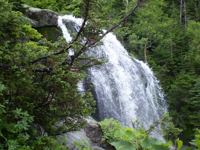
All of the trails on Mt. Washington offer something a bit different. The Ammonoosuc Ravine Trail's main feature is the picturesque waterfalls and the Ammonoosuc River, which runs down the mountain, and into the ravine. This waterfall shown below is one of the most beautiful waterfalls I have ever seen up close. Because it was July, the water on the mountain was screaming down the mountain where ever there was a stream.

As the ascent continues, the trail becomes just about completely rocky. I then made it to the AMC Lakes of the Clouds Hut, where I stopped quickly for an energy bar. One of the things I will never forget is having to put on my winter hat and rain jacket as I left, as the weather had picked up in the way of misting dense fog and periodic wind gusts nearing 70mph.
Large waterfall on the Ammonoosuc Ravine Trail
The weather did not pose much of a problem, as it cleared within an hour or so, and was just about gone as I reached the summit at 6288ft. When you do something like this, taking on a landscape and mother nature, I truly felt the sense of accomplishment, yet also the desire to do other things outdoors.

Hike Stats
Trails: Ammonoosuc Ravine Trail, Crawford Path
Mileage: 4.5 mi.
Elevation Gain: 3800ft
Book Time: 4:40

How I got into Hiking...

Mt. Washington summit 2007
In July of 2007, I pretty much decided to just "get up and go" hike the Northeast's tallest mountain, Mt. Washington in NH. I did it solo, and made it to the top in just over 4 hours. In my opinion, this is one challenge, that most in-shape people can succeed in doing. On the way up the west side of the mountain, I experienced picturesque waterfalls along the Ammonoosuc Ravine Trail, beautiful sunshine, and friendly puffy clouds. Although a beautiful day, I still experienced a dense misting fog and a few gusts nearing 70mph while above treeline.

This really was the first thing that got me into hiking and enjoying the outdoors. In another post, I will talk about why it is so enjoyable, for me anyways, to get outside and away from the hustle and bustle of everyday life. It is much different. After this excursion, it opened the door for me to keep going and to experience new places in a variety of different ways.

Get outside, and I hope you enjoy my blog!