Monday, November 28, 2011

Mt. Isolation & Isolation, North Peak Overnight - 11/27/11

I hope everyone had a great Thanksgiving weekend! I really had trouble deciding where to hike this weekend, so I just went to the Trailwright's list and chose one. That crazy choice would be North Isolation. I was at my place in NH on Friday night, and after packing up all my gear, I noticed I completely forgot my camera that was charging at home in MA. My cell phone camera would have to do for this one.

I started my trek up Rocky Branch Trail just after 7am on Saturday morning. There were only boot marks leading up the trail in the 6 inches or so of snow, which went to about 2500 feet, where the tracks may have turned around. From here, I broke the trail all of the way to the shelter, and then to Davis Path. The wet snow was close to a foot in some "isolated" areas. 

The crossing of the Rocky Branch was not difficult. It still required focus as the rocks were covered with several inches of snow. I crossed about 20 feet to the right of the end of the trail. I checked in at the shelter, and shed some of my weight (tent, some extra clothes, stove, extra drinks). I put them in a trash bag and placed them out-of-sight nearby. I had decided then that no matter what I would camp at the shelter, even though there are some other campsites around that would have been nice to try. I didn't waste any time and continued up the Isolation Trail, still breakin' it out, which is tough work especially when the snow is so heavy and wet. It was warm out, but the snow had not been turned into slush yet. I remembered the area well from my hike in June, and felt confident breaking the right trail. This section is not easy to navigate with snow or without snow, and its easy to get messed up near the spot of the campsite a short distance before the Davis Path. But, not this time, as I remembered and continued on, making my way to the junction with the Davis Path, where I saw snow shoe tracks in both directions. I made it to this point in 5hrs and 20min. 
Rocky Branch crossing
Rocky Branch to Jericho Rd. Closed
Isolation Trail (east) and Davis Path junction
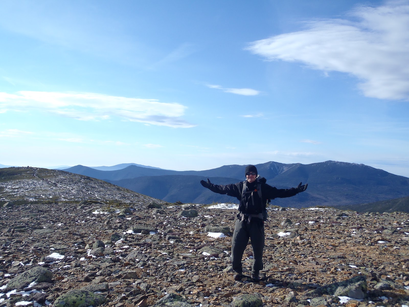
I took a right onto the Davis Path for .3 mi and arrived at the junction with the Isolation Trail (West). Here, I dropped my pack, taking a few essentials and headed the approximately 1/4 mile up towards North Isolation. As I neared the top, I could see the range rise to the north directly above the trail. I stopped as it started to descend, and realized I definitely went far enough, so I went back to the high point on the trail. I knew the actual high point was some where off-trail a short distance, but couldn't see any ideal paths into the scrub, so I felt my effort (and craziness to go there anyways) was good enough, so I took a couple of moments to enjoy my 33rd Trailwright peak. After, I quickly shoed my way back through the nice snow along this section to where my pack was.
Me on North Isolation, 33rd Trailwright
I continued on the Davis Path, passing the Isolation Trail junction where I came from. I had a mile to go to reach Isolation. It was nice to have some tracks to follow along this easy section of trail. After the short steep climb to the summit, I was greeted with a decent overcast view of the high peaks to the north, and a satisfactory view of the southern Presi's and other mountains all around. I could hear the wind hovering over the high peaks several miles away. This was my second time to the summit of Isolation this year, and first time solo. I spent a little less than 10 minutes on the summit, before I became chilled and retreated to the protection of the Davis Path to eat a turkey sandwich for lunch.
From the summit of Mt. Isolation
Although the elevation gain is pretty easy throughout the hike, when standing out there on top of one of the most remote peaks in the Whites, it's an interesting realization of how far away help is, if needed; it's a challenge one must accept when hiking Mt. Isolation (or any remote peak). Don't go to Isolation expecting dry boots and don't expect a hike here without falling on your ass a few times, because I sure did.

As I started my way back to the Rocky Branch Shelter, it was around 1:30pm. I had allowed myself plenty of time to get back in time before daylight faded. I actually had a much better wind than on my approach, and I was moving pretty swiftly on the way back, following my tracks. I made it back to the shelter about one hour before daylight faded. I tried scouring the area for some dead twigs or anything I could use to attempt to get a small fire going in the ring, however I had no luck when I tried, as everything was soaked from the melting snow. That was a buzzkill, as I realized that my boots would not get dried out. These are waterproof hiking boots that had not spilled a drip since I bought them, but Isolation's wet melting snow, and water-filled trails can be no match for any boot. I set up my tent, got situated, and then I fired up my stove and had a nice freeze-dried pasta meal, and got settled for the night pretty early. After all, it was about 4:45pm, and it was pitch black!
Rocky Branch Shelter #2
I awoke a few times during the night, but for the most part slept really well. I call it a success because I got more hours of sleep and rest than I do at home, so that was good. The Rocky Branch roared below me, and it was the only thing I could hear. I almost seems as if the river changes and makes different noises at different times but who knows, maybe its just imagination. I heard the wind pick up for a few hours right in the middle of the night. It made my rain fly shake, which of course woke me up. When I did wake up, I remember eating a few snacks, as this keeps the body working on the inside, generating heat. I fared very well through the night with all my gear, and used just about everything on this trip except for some of the emergency essentials. I was warm all night, although I will admit if it had gotten down below freezing, my boots would have froze, and I would have had to work to stay warm.

When I woke up, it was cool out. There was a fog that floated near the tops of the trees. It was about 8:30ish when I started packing everything up. It's nice to sleep in when camping out. However, it took me a few minutes to get the juices flowing after eating my milk and blueberry granola and coffee. The one thing I didn't want to do this morning was take off my down booties. The very last thing I did before descending to the river crossing was put on my soaking wet boots. Thankfully, I had brought a pair of sock liners AND 2 extra socks, so I put on my liners with my really thick wool socks and got going.
View from the shelter in the morning
The hike out was long, as always, and felt the same as any other 4 mile haul out of the woods. After about 15 minutes, I could feel the squishing in my boots again. The snow was much more slushy today, but the snow shoes still helped a ton, and I wore them to about the wilderness sign. Throughout the whole hike, I startled two birds, and I was lucky enough to spot a third that had not fluttered his way through the trees and allowed me to snap a picture. The rest of the way, I was remembering certain landmarks I've come to remember on the Rocky Branch Trail, and I knew that I was making great progress on my trek out. I reached my car around 11:30am, and was back on the North Shore in time to watch the Pats. What a hike! I love Mt. Isolation!

Hike Stats
Trails: Rocky Branch Trail, Isolation Trail, Davis Path
Distance: 15.6 miles
Elevation Gain: 3500 feet
Book Time: 28hrs 30min

To view the full album from this hike, view or click on the slide show below.

Wednesday, November 23, 2011

Mt. Starr King & Waumbek - 11/20/11

Having stayed at a motel in Twin Mountain, we got a nice 7:20am start to our hike this past Sunday to Mt. Starr King and Mt. Waumbek. I've been sitting back and allowing Bill to choose his hikes as we make our way to his completion of the 48. We could have hiked Carrigain or the Hancocks, but we opted for the shortest available on day two of our weekend by choosing Waumbek. It's always nice to get back home at a reasonable time on Sunday too, although personally, I wish I could stay in the mountains all week....
Starr King Trailhead
There were no cars at the trail head when we started, and there was a spitting rain as we started up the Starr King Trail. There was an eerie silence in the forest at the beginning of the hike. It seemed as if we were hiking into the weather as we ascended, so it was uncertain as to when it would lift. Slowly it did, and it became brighter, but it always seemed like the sun was struggling to break through. Compared to Zealand the day before, there was no snow at all near the bottom. We continued up the Starr King Trail, which is a steady, gradual climb, which is not exactly easy after hiking the day before. It's the type of trail where you think to yourself that you almost wish for some rock hopping and climbing, but instead its like walking up a really long hill.

As we climbed higher, making the swing to the left side of Starr King as the trail approaches the summit, the same coating of snow we witnessed yesterday started to come into play. It was about this point where the weather became a little different. It was much colder and windier than it was about a mile back and below. We reached the summit of Starr King at 3907' .

Summit of Mt. Starr King
We passed the cool looking fire place on the summit clearing and continued on towards Mt. Waumbek. The wind continued to howl over the tree tops, and sometimes had enough force to make it felt at trail level. It was much colder than the lower half of this hike's elevation. The hike between Starr King and Waumbek is gentle and pleasant, even in late fall weird conditions, and we made it to the summit of Mt. Waumbek, which was my brother's 40th of 48 in 2011.

Bill on his 40th summit of 2011
On the way back and with only one direction to go, down, we started on our quick exit from the summit. We stopped for a couple of quick summit photos on Starr King that we didn't take time for earlier, but that was about it. We matched the book time of my same hike in June hike at four hours. As we descended there were  many hikers, all with dogs heading up the trail. We were bundled up from being on the other side of the peak while the folks heading up the trail were in T-shirts, so we informed them it was a little cooler at the top. We were done before noon, and back home later in the afternoon to reflect on an enjoyable two hikes in the mountains.

Hike Stats
Trails: Starr King Trail
Distance: 7.2 miles
Elevation Gain: 2650 feet
Book Time: 4hrs

To view the full album from this hike, view or click on the slide show below.

Tuesday, November 22, 2011

Mt. Zealand & Guyot 11/19/11


What to be thankful for this week? How about another weekend of incredible New England weather in the mountains. My brother and I decided to take on Mt. Zealand and Mt. Guyot on Saturday before it got fishy as to when the road would be closed. Here began the push for Bill's final 10 White Mountain 4000 footers.

From the start there was a thin coating of snow on the trail and through the woods. The hike in was very pleasant, and it was the first time headed up the easy Zealand Trail. It was very picturesque and we enjoyed this area very much. There were several bridges along the trail that skirt and cross the boggy area. The open area offered great views, especially up to Zealand, but no luck with any wildlife. I'll never see anything!


We stopped at the waterfall lookout below the hut, where there is a stand of some sort. My guess is that it must be for wildlife viewing? I have not seen anything like that anywhere else. The waterfall below the hut was impressive, so we stopped a second to snap a few pictures there. We then made our way up to Zealand Falls Hut, where we took a super quick break before moving on. When we did, we came across another very impressive waterfall above the hut.
Me at waterfall below the hut
Zealand Falls Hut
Falls above the hut
As we ascended, the coating of snow remained consistent, but never posed any issue. Our traction stayed in the packs all day. The section from the hut up to the cliff is pretty steep within the distance it travels. The reward is the incredible view from Zeacliff, which was another new Pemi vantage point in the books for me. I loved the view of Carrigain and the Hancocks.
Mt. Carrigain from Zeacliff
Tom, Field, Willey, and the Presidentials from Zeacliff...awesome
We haven't even made the view-less summit of Zealand, and the views on the way were already satisfying enough for the whole hike. We climbed higher on our way to Zealand. The sun was beaming through the trees and the weather was comfortable. We passed a few tricky spots, the ladder, and continued to the summit spur.
Icy Twinway - I don't like the Twinway on this side either!
Bill coming up over the icy section
We hiked along the spur trail to the summit. Zealand was peak number 39 for Bill and my second time to Zealand this year. Although nothing there at the summit but a fancy sign and regular looking cairn, we were enjoying the hike, feeling good, and enjoying the sun-splashed summit.
Me and Bill at the summit of Mt. Zealand
We hiked on the Twinway toward Mt. Guyot. The trail between here is pretty easy. As we descended from Zealand though, it appeared to us that it seemed far to where we were going. However, sometimes its easier than it looks (sometimes its not always the case). I've hiked this section before, but sometimes you see something you didn't before. Despite how far it looked, it didn't take us long to get there, and Mt. Guyot is a unique peak. The scrub is about waist to shoulder high as you crest the summit where there is a bare section of rocks that overlooks the Pemi Wilderness.
Bill standing in front of what will be his final challenge
Me strolling around the summit looking all over the Pemi
I've counted this claim of Guyot as my 32nd Trailwright72 peak. Although not on the list of 4000 footers, Guyot is 4580' and creeps out from the trees just a little bit. This was a great and enjoyable hike, and it had it all including outstanding views from Zeacliff, a view-less summit, an exposed summit, waterfalls, snow, sun, Zealand Falls Hut (which is open), and picturesque Zealand Pond. We hiked out feeling good ready for the next one.
Zealand Trail close to trailhead
Since we were hiking on Sunday too, instead of driving back to our place near Tilton we opted to stay in Twin Mountain at the Four Seasons Motor Inn. It was well worth it, as we enjoyed a great meal down the street and then went back to the room and watched the Bruins until we passed out.

Hike Stats
Trails: Zealand Trail, Twinway
Distance: 12.8 miles
Elevation Gain: 2850 feet
Book Time: 7hrs 35min

To view the full album from this hike, view or click on the slide show below.

Monday, November 14, 2011

Mt. Washington, Mt. Monroe, Boott Spur - 11/13/11


It was a perfect day to do my most recent favorite hike all over again and knock off Mt. Washington and Monroe in November. This was my fifth time to the summit of Mt. Washington, and 3rd time to Mt. Monroe this year, and on this trip it was my 31st Trailwright peak. I also got to visit Boott Spur again. The weather was perfect the entire time with the highest winds only at the summits. The average wind on the summit was 61mph and visibility was listed as 70 miles.

As I pulled into the Pinkham Notch Visitor Center parking lot, I couldn't wait to get out of the car. The sun was just rising over the Wildcats spilling its rays onto the top of the high peaks. At 7am, I started up the Tuckerman Ravine Ravine Trail. Although the trail looks snowy, it was pretty much bare, and posed no difficulty all of the way to Lion Head Trail.
Tuckerman Ravine Trail
I made it to the Lion Head Trail summer route (winter route not open yet) and continued on bare-booting. As I went along, there was still a slight haze to the east, but there was blue sky right above me, up over the mountain. The wind picked up slightly as I made it out of the trees. The crystal clear and impressive ravine views were incredible on the approach to Lion's Head. It got a little bit colder and windier as I continued past Lion's Head and approached the top of the ravine. I now had my microspikes on. I love the blue/pinkish colors of the sky during snowy hikes, and feeling good I was moving along just keeping my eyes to those views.
Switchback and steep section on the Lion Head Trail
Top of Tuckerman Ravine
The push to summit was fun. The wind was ripping, making it tough to keep my step on target as I climbed the last few rocks. When I made it, I had to hang on to the sign or fall down. There was someone else who had just reached the summit shortly before me who captured my summit photo. I stood around for a couple of minutes myself in the wind taking in the full wrath and views from the high point before ducking out of the wind for a minute.
Me on the summit of Mt. Washington for the 5th time.
As I started to descend on the Crawford Path, the wind was coming across pretty good still, so that required me to stop and get out the ski goggles. I passed two pairs on the way down this section, and saw a guy fixing the chimney on the hut at Lake of the Clouds; after that, I didn't see anyone else until I finished. Lake of the Clouds was iced over, but not completely. Still looked beautiful as ever against the blue sky and rime.
Lake of the Clouds
I love the steep climb to Monroe. This was the first time I made the approach to this awesome summit with no one else on it. When I got to the top, I looked around and still saw no one, and the mounds of mountains seemed to be endless. I think the views were the best I've had from any trips to the Presidential's.
Mt. Monroe, 31st TW72 peak
It was about 1:30pm on the summit of Mt. Monroe, and the sun appeared as if it was already starting to set, which is incredible. It's very easily to overestimate daylight during this time of year. I quickly descended Monroe and I pretty much hiked continuously, without stopping, to Boott Spur. I quickly made a stop at the marker and continued down. After Boott Spur, I took off the spikes as they were no longer needed, and on this side of the mountain there was the least amount of snow and ice. I took a break at treeline to mow down a bunch of snacks and an Advil for the rest of the arduous descent.
Along the Camel Trail 
There were many planes taking in the beautiful day
After a handful of steep sections, the Boott Spur Trail evens out in places as it approaches the junction with the Tuckerman Ravine Trail. By no means is it an easy descent, but I really like it because it comes out pretty close to the end on Tuckerman, so once there I can swiftly jog back to my car. It's amazing that I can complete a hike like this and feel great, like I went for a walk in the park. I've now climbed over 100 named peaks this year alone, including a NH 4000 footer over 70 times. Yikes! I'm starting to not believe this myself! Thanks for reading everyone.
Looking down into Pinkham Notch
Lower Tuckerman Ravine Trail
Hike Stats:
Trails: Tuckerman Ravine Trail, Lion Head Trail, Tuckerman Ravine Trail, Crawfrod Path, Monroe Loop, Camel Trail, Davis Path, Boott Spur Trail
Distance: 10.6 miles
Elevation Gain: 5,050 ft
Book Time: 8hrs 40min

To view the full album, view or click on the slide show below.

Sunday, November 6, 2011

North Twin, South Twin, Galehead, & Garfield - 11/5/11


Back to the mountains this weekend.With this hike of 4 peaks in the books, my brother will be heading down the final stretch with 10 more to go. We were planning for a half pemi-traverse from North Twin to Lincoln Woods to bag 8 total, however the tricky crossings at the start as well as re-adapting to traveling on snow packed trails slowed us down a little, so we returned to the start car. Bill checked off 4 more peaks, and I reached my 30th Trailwright 72 peak and checked 4 more peaks off my grid for November. I have now hiked Mt. Garfield, Galehead and South Twin 3 times each since January and each in 3 different months, making me a master grid planner. Check out my progress here.

We started out at 5:15am from the North Twin Trail trailhead. The trail started out with a couple of inches of snow and then quickly changed to several inches of packed snow. In anticipation of the conditions, we had switched to our winter hiking boots for this hike. We bare booted most of the entire hike, and used micros a little. Each of the three river crossings were a challenge. The first one (shown below) required us to traverse a log over a swift moving section of the river. It took a while to find this too, but once we did, I switched into adventure mode and went for it. At the next one, we walked across one smaller log as we held onto another larger log at chest height over a deep pool, then rock hopped the other half of that crossing. On the third crossing, I had leaped over a large pool close to the bank which enabled me to hop across the rest of the way. However, this was rosky, as that leap and then the final rock hops required momentum. Bill was lining up to take the same leap, however couldn't commit. After a few more minutes, he found a satisfactory route, but he still had to use a partially submerged rock. This stuff took some time away from our plan..
Crossing the Little River on North Twin Trail
After the crossings, we made some progress as the sky started to lighten.
North Twin Trail 
As we approached the summit of North Twin, the snow was snowshoe-able. It brought back the first memories of hiking in winter earlier this year. It was also a reminder that winter hiking is a different animal (Even though its not winter yet!). The sky was just starting to clear and the air was crisp as we made the summit of North Twin. We had no views from the viewpoint just yet, but...in the blink of an eye and by the time we started towards South Twin, the clouds were gone and we were into the beautiful day that was expected. We hiked through a sun blasted winter wonderland with crystal clear views to Mt. Washington.
North Twin Spur
Me on North Twin Spur posing with the Presidentials
The Presidentials were sure nice to look at....but easily comparable in beauty is the expansive views from the North of the Pemigewasset Wilderness which I knew Bill would enjoy.
Looking southeast from a viewpoint on North Twin Spur
I've said it before, I think South Twin is a tough climb, which ever way you approach it. When you look at South Twin from its neighbors, it towers. We came of the scrub and up onto the rocky summit with  incredible views.
North Twin Spur sign at S. Twin summit with Mt. Washington
We headed down the steep Twinway to Galehead Hut. We took a little break, dropped our packs, and headed to the summit of Galehead Mountain where the viewpoint along the way provides a great view of Galehead Hut and the Twins.
View from viewpoint near Galehead Mountain summit
After Galehead we proceeded west on the strenuous Garfield Ridge Trail towards Mt. Garfield. The approach towards Garfield had us going up and down, and then up some of the steep sections of Garfield Ridge Trail, which were icy. Eventually we made the summit, which was occupied by nearly two dozen hikers. Again, the views endless.
Love the view of Owl's Head and the Pemi from Garfield...
If we continued ascending as planned along Franconia Ridge, we would be hiking well into the night, and we wanted to efficiently use day light to descend before we got in too far, plus Bill was feeling sore. We descended the Garfield Trail and took the Gale River Loop Road and other forest service roads back to our start car at the North Twin trailhead. We took a right off Gale River Loop Road. This is the road between Gale River Loop and Haystack. Although its shown fully on the AMC map, the road shrinks to narrow footpaths along old logging cut-outs. The orange glow of the sunset illuminated the peaks behind us as walked along this less traveled hillside down to Haystack Road.

Hike Stats
Trails: North Twin Trail, North Twin Spur, Twinway, Frost Trail, Garfield Ridge Trail, Garfield Trail, Gale River Loop Road, other forest service road, Haystack Road
Distance: 20.7 miles
Elevation Gain: 5650 feet
Book Time: 13hrs 30min

To view the full album from this hike, view or click on the slide show below.