About a month ago a hike was planned with some friends and others to do a fun-themed "haunted hike" after talking about the tale of Doc Benton a while back. We thought it would be great to hike up with a nice group, take some fun costume summit photos and search for Doc Benton. Perfect for my 8-yr niece, who's next mountain choice was Moosilauke, we had been patiently awaiting today's adventure. In the Halloween spirit, me, my brother, and niece were on our way Sunday morning. We were racing away from the clouds on the way up, and the looks of it, we were going to get some views.
My buddy communicated to me that the witches in the woods fed them too much poison to drink last night, and that the effects would not wear off in time to come on the hike. Having not seen any of the other 8 or so people cancel, we hoped to see some others at the trailhead. We got to the trailhead at Tunnel Brook Road, to see nobody else waiting. We were really scared because we didn't know if Doc Benton ate everyone or cooked them up in his stew, or whether everyone decided to not come and didn't think to mention it on the event page. The only person there was a guy straight out of Gold Rush Alaska, who had camped the night panning for gold in the area.
Tunnel Brook Road
Normally, we start our hikes much earlier, especially with the impending storm, but with the planned 10:30 start time, and it being almost 11, we decided to head up on our own. Feeling slightly disappointed at what has just occurred, it was tough to get motivated as we walked down the Tunnel Brook Road, which still sits obliterated by Irene.
Irene damage on Tunnel Brook Road
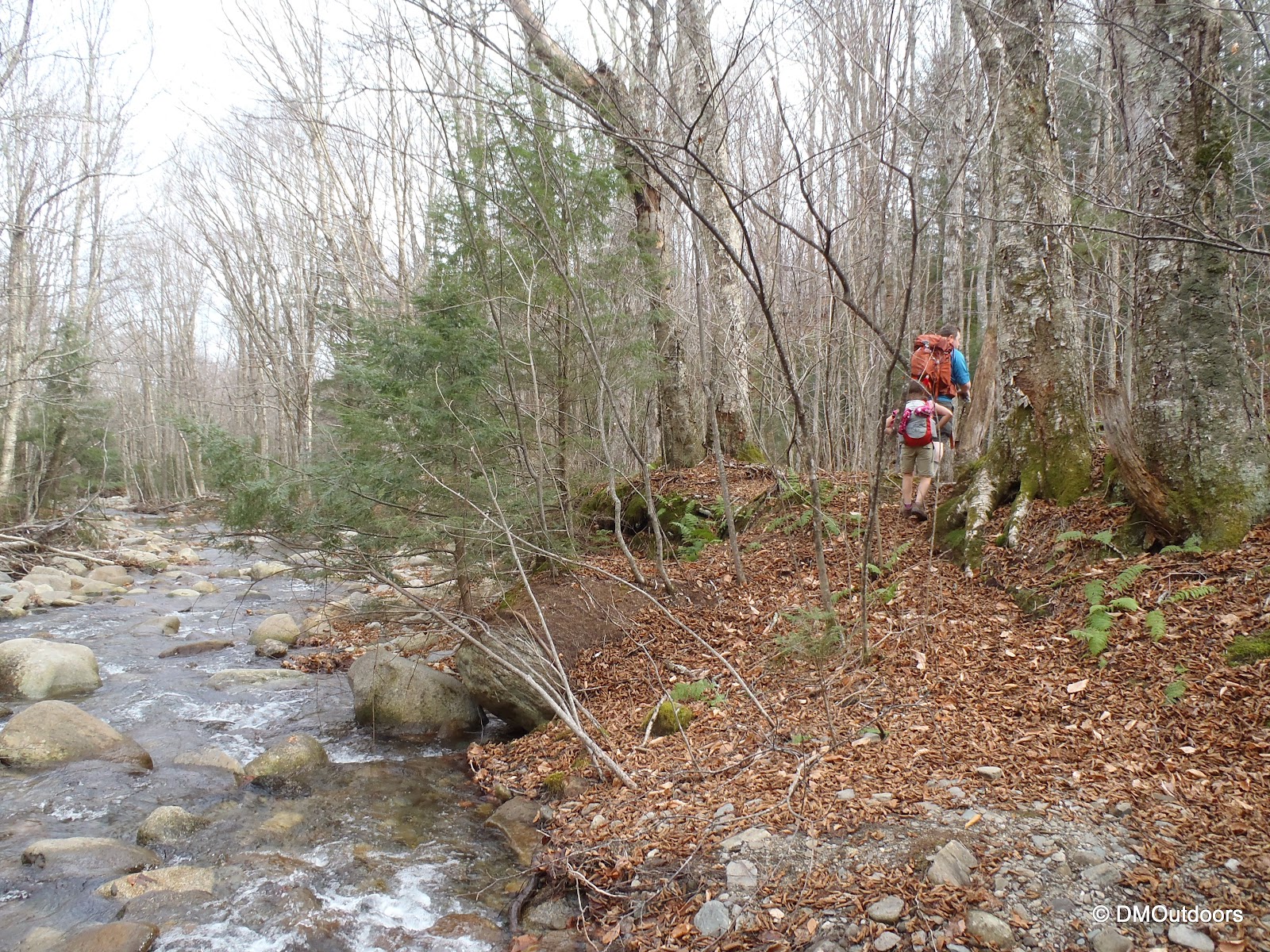
We arrived at the Benton Trail on the left, and took a snack break. We were excited to get on the trail to mix it up. We signed the register, and came to the brook crossing. From where the trail crosses, a spot just a bit to the right was the best spot to cross. Now we were on to the leaf covered trail, ascending gradually. The woods were quiet, and despite it being October, it was quite warm, and we removed layers early. Hiking in the leaves is pretty tough, and the Benton Trail is not very clearly marked, but it was no problem, having done the same trail last October!
Start of the Benton Trail
Safely across and on the way up
Ferns and fallen leaves on the Benton Trail
It seemed like we'd never get to the first outlook into Tunnel Ravine, which is 1.3 miles from the start of the Benton Trail. To help keep the excitement up from the rather dull trail, we decided to try to make calls out for Doc Benton. Along the trail we searched, and although we didn't find any signs of him yet, we did get frightened by a scary green creature in the woods. After the frightening encounter, we realized that we survived and we took a nice break to enjoy the great view of the ravine.
Tunnel Ravine, Mt. Moosilauke
Looking out of Tunnel Ravine from the first outlook
Onward and upward we went at the pace of smaller legs. The leaves no longer covered the trail, making it easier for us to find our footings. We passed a new and impassable blow down. Eventually, many breaks later, we arrived at the junction with the Beaver Brook Trail. We were now about to experience the grandeur of the Moose once again, and share it for the first time with a lil' devil of a mountain climber.
My niece taking us to her 5th New England 4000-footer!
Impassable blow down on Benton Trail
HE-HE-HE, HA-HA-HA
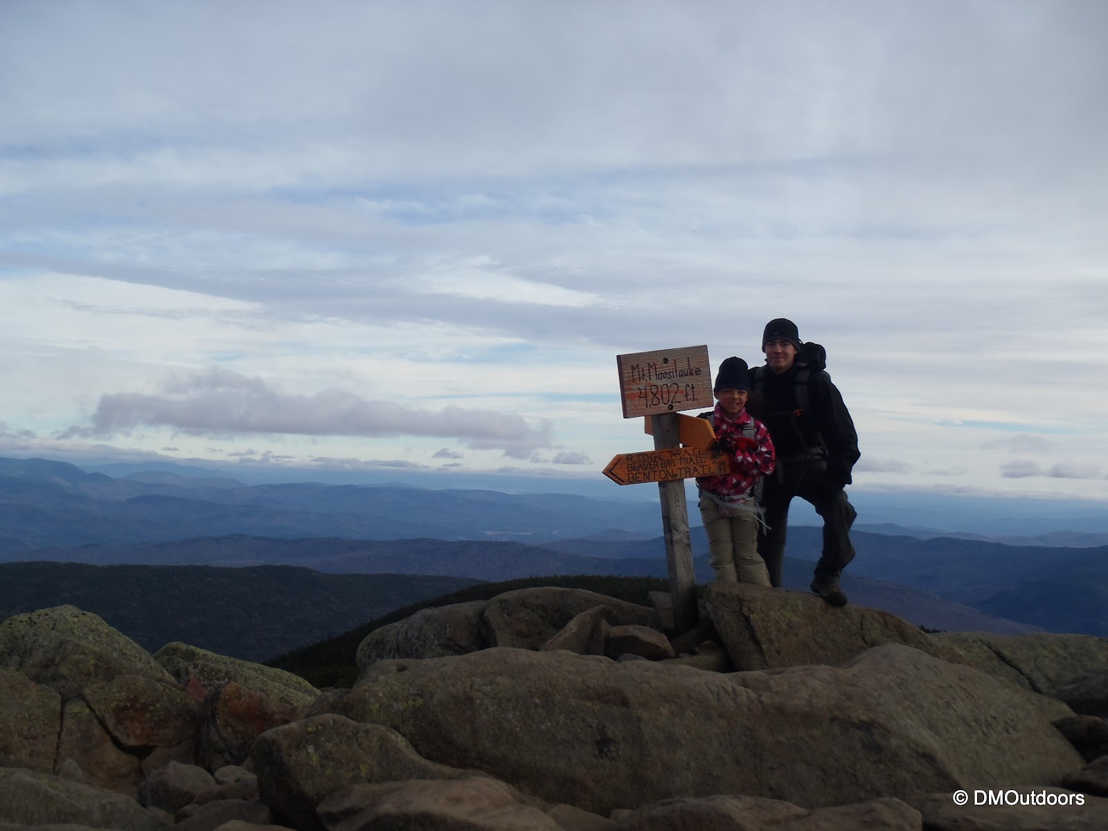
This literally was the moment we had been waiting for all day long, to pop out onto the magnificent and broad summit of Mt. Moosilauke, and traverse .4 miles across the exposed summit to the summit. There was a consistent wind, dropping the temperature likely into the 30s. The first thing we wanted to see was Franconia Ridge. We stopped a moment to make some final comfort adjustments as we took in the beauty of the land around us. Then, we marched on, I behind my brother who was proudly following his lil' devil to the haunted and awesome summit of Mt. Moosilauke (4,802').
The summit views were spectacular. The clouds and ominous atmosphere sealed the deal for making this a spooky fun hike, and at the same time it was just as intriguing and unique for me, as this was my fourth time to the summit of Moosilauke. In the distance, Sandy's clouds were making their way into southern NH. We were anticipating a big group for a costume summit shot, but instead, everyone must have been scared off by us spooky creatures who had taken over the summit of Moosilauke. We embraced the beautiful summit, the ominous day, and the make believe happenings in the woods around us. The overwhelming feeling turned us into scary summit-hungry creatures.
After about 15 minutes of posing for a variety of photos to always remember this special hike, we hunkered down behind the rocks to get ready for the trek back into the woods. The hands were starting to crack in the cold, and the clouds had engulfed the top of Franconia Ridge. It was time to go. Sandy was fast approaching. One thing that we taught to the lil' devil on that summit yesterday, was that on some days, and sometimes when you least expect it, the mountains will reward you. "How does that happen, she asked?" That one was all Bill's. Moosilauke surely rewarded us. Furthermore, when it comes to the mountains, the wilderness, and the outdoors, one must rely on your own self. We missed out on meeting some new friends, but I have no doubt in my mind that years from now, we'll always talk about the story of the lil' devil and her crazy creatures of a Dad and Uncle who climbed Mt. Moosilauke in the full spirit of Halloween.
Our descent was peaceful. The clouds were most definitely on the increase, and light was fading. We enjoyed a lengthy second stop at the view into Tunnel Ravine. We readied our flashlights and headlamps, descended the tricky trail, now again covered in a thick layer of dry, slippery leaves. Darkness arrived. Shortly thereafter, during a needed break, we could see the light of the true full moon appear over the ridgeline above and behind us. Continuing on, we carefully followed the trail to the brook crossing, where we easily crossed in the same location and made it back to the road. In no hurry at all, we walked back down the road under the full moon which seemed to turn on and off amid the thick passing clouds, and behind the spooky leaf-less trees. Despite the ominous appearance, it was really such a beautiful day and night in the mountains. It was never scary at all, and we had nothing but silly imaginations of lurking creatures and all laughs.
Hope you enjoyed this one! Happy Halloween everyone!
After finishing my 48 in August 2011 via a Moonlight Presi Traverse with my brother, we were hiking towards the end of his 48 in one year, led by his determination, we were squeezing hikes in to accomplish it in the same one year I had set out for. Between that August and this date last October, I had gone onto Pemi Loops, Grafton Loops, and the like, and the weekends between, we knocked of the Kinsman's, Owl's Head, and Jackson for Bill. Hiking crazy hikes going nuts across tough terrain, we were on a roll. That was until a hike on October 22, 2011 (close to a year ago today) that gave us a reality check. Of course we had a cool plan to start a night-hike to the Horn, Bulge, and Cabot, for an attempt to traverse the Kilkenny Ridge to Waumbek by early Sunday. After being slowly soaked by increasingly dense fog, a chilly Cabot almost did us in. Along the way we heard a loud smash in the woods I remember clear as day. Both of these things were not really highlighted in my original post, so it's a good one to take you back inside the moment.
By the time the car spot was done at Starr King, and we were at York Pond Road on that Friday night, we were quite tired, so we napped about an hour and a half until about midnight, and then we set off on the Unknown Pond Trail. (If you have the time, first go back to the original trip report here before continuing.)
Unknown Pond Trail
It was a raw, wet, damp night, and the leaves were slick as we made our way down the Unknown Pond Trail just after midnight. What a beautiful trail, but I will have to hike it again to see it in the daytime. We were pushing along about halfway up to Unknown Pond when we both heard a distinctive sound of tree in the woods. It was as if something crashed in the woods, but it was sort of like one loud thump and echo. My brother described it as, "sounded like something huge took a 50-foot tree and slammed it up against another tree, like a baseball swing." Immediately we were thinking Sasquatch, but no, this sound was real, weird, and the feeling we both had was that sound was not just a tree falling. We're hopeful we startled a Moose or something and it was not a Sasquatch, but after a few minutes of looking around nervously, we continued hiking at a VERY swift pace up the hill towards Unknown Pond, crossing the raging outlet from the pond using two sticks for balance. It was one of a few a un-explainable things we've encountered on the trails, especially at night. There was no wind at the time, and it would be tough for a tree in dead-fall to make that noise. Very spooky nonetheless.
Looking our over Unknown Pond (I think)
We made it to Unknown Pond, and there was no fog yet. I remember shining my light over the pond, and seeing darkness, and no fog in the path of the flashlight. However afterwards were making our way over the Horn and Bulge, and we were engulfed in thick wet fog. On the Horn, we could hardly get up onto the rocks they were so slick, and after about 30 seconds on the summit and a couple of quick pictures, we decided we better get back onto some soil before we fall. It was ice. Then it started to spit a very light mixed precipitation as we made our way to over to Cabot.
Bulge summit, not knowing I'd be shivering very shortly
Now, approaching Cabot, we had progressively been ascending into the wetter fog, but being in the trees, I guess it was hard to tell, but we were actually getting pretty soaked. We didn't have waterproof gloves for this hike, but we both did have two pairs each. They were soaked, and my fleece was really damp from me not noticing how wet the outside was before putting on my waterproof layer. Our pants were soaked through to our legs from the wet trail and precipitation. At the summit of Cabot, it was certainly close to freezing, as pellets of sleet were flying. My brother was in a similar situation, so after hitting the summit, Cabot Cabin was looking really nice....at least we thought.
Bill on his first summit of Mt Cabot, a memorable one for sure
We got into the cabin and the first thing we did was put our base layers on next to our body, and then put some of the other clothes back on over. We changed into some dry socks even though our boots were completely soaked. There was absolutely no way for us to dry anything without starting a fire, which was pretty much out of the question. Standing in the cabin, I clearly remember shivering trying to get warm. We marched around the cabin for quite some time as the wind gusted occasionally outside. We saw there were some foam sleeping pads already secured to the bunks. Eventually, we decided to sit on one of the top bunks back-to-back, and try to rest a bit, warm ourselves if possible, and wait for sunrise just a couple of hours away. A couple of long hours that I think back to as a definite learning experience. Just because its not a raging rain or snow storm, doesn't mean you can run into a little trouble with hypothermia, even when you think you have packed everything you need.
Bill looking out, wondering when daylight might come
"Dan, it's snowing out, should we get moving?"
About to leave the cabin after our unexpected "Cold night on Cabot"
Just before actual sunrise, we sluggishly geared up upon the sight of grey sky and stepped outside the hut to see it flurrying with snow. This was not good, but it instead of stopping altogether for us, it turned to a rain as we arrived at the Bunnell Notch Trail junction. Clearly with it raining and after what we experienced, we made the easy decision to head back to the car at the hatchery instead of continuing with the traverse.
Even after a lot peaks in the prior seven months and some really intense hiking, we still had a lot to learn about hiking (and there still is). Us each having that full unused base layer and extra socks that night was the key for us being able to stick this one out. However from this, we learned that if we had gaiters, our pants wouldn't have been so wet. If our gloves were waterproof instead of "weather-proof", our hands might have been warmer. If we had a stove, we could have cooked a meal to warm-up. Those were just a few things we learned on this one. We didn't expect the fog to create such wet conditions before it actually started to precipitate. It was only near freezing, and we learned that's all it takes when mixed with wet gear. It was all a matter of these things coming together on that night to give us a run for our money. We are thankful it did not turn into a more serious situation, but at the same time, I'm glad that we both went through it because, for me, I know that I never want to be that wet in any colder conditions ever again. It sticks with me every time I plan a hike.
After this, and prior to the impending winter, we started to bulk up our gear closet, starting with the purchase of some gaiters and better gloves and stuff. When it hits October, the White Mountains are unpredictable. Having the correct gear to cover the number of situations that one might face could make all of the difference in getting you through an unexpected cold night. Be prepared, always bring the 10 essentials and more, and always consider the minor details.
Now, another year later, both my brother and I are still challenging ourselves, learning as we go, and enjoying every adventure we can! Hike on and stay safe!
So, life is busy, work is busy, and there's always something going on for me. Sometimes its tough to keep up. I wrote the first five ITM episodes mostly in advance, but today, I was stuck on what to write for this week's episode, so this one's coming to you on the fly. The first thing I did was look at my calendar as I hopped in the car this morning, and quickly it dawned on me, that its been 4 months exactly to the date since I stood atop the summit of Mt. Whitney at 14,505 feet on June 19th. However, it feels like it was an eternity ago, and....
I am dying to get back there again. Not only was just being there amazing, but I think about everything I did for this trip, and how it started way back in February of 2011. All of that time waiting until spring for the lottery results, and all of the time spent researching and planning the trip (while hiking 4000 footers in NH on the regular), made this trip bigger than I could have ever imagined. As a whole, it consumed many months of a single year, not just 3 beautiful days in the Sierra Nevada's. When you read and research for Mt. Whitney, there is so much history and so many stories, that it was hard not to put it up on a pedestal as this magical place that clearly would blow us away. Its a place with rich history and a summit log that contains some important people of past times. With all of that in mind, it was like we had read all about this magical place, and then inserted ourselves to it, and out came an incredible and unforgettable adventure, our very own, for us to always remember.
Many, many, mornings from February to June, checking the Mt. Whitney webcam was a ritual. We saw countless sunrises and amazing shots, but there was nothing quite like seeing that view in person when we arrived in Lone Pine, and then on June 19th, we were a part of that Whitney sunrise we saw so many mornings before. My brother and I talk about this trip on a regular basis. It always comes up...the moments of the trip, huffing and puffing our way down to the open meadow at Horseshoe Meadow - our first time to 10,000 feet ever, the Trail Crest sunrise with Venus and Jupiter, the first sight into Sequoia National Park at Trail Crest, and ultimately, approaching and standing on the summit of the highest peak in the lower United States.
I remember approaching the summit, looking up at the hut, and thinking, are we ever going to make it. It felt as if the last steps were the most difficult, each one requiring its own breath to match. With my GoPro recording, I remember doing a narration for the camera that it was "June 19th, 2012 and we're approaching the summit of Mt. Whitney at 14,505 feet". I added that there were "no words to describe what we see around us right now". That moment I started to speak to the camera, I could feel in my throat and hear through the wind the choking of my voice, as at that point, it was tough to hold back the emotions taking over as we took those final steps to the summit.
I could write an episode about every different moment on this trip, but today, in the spur of the moment four months later, I think back on how such a beautiful place can take over your emotions and thoughts in such a way. I'm looking forward to going back again someday so that I can feel the same way all over again.
To read the trip report and see more photos from my June Mt.Whitney adventure, click here.
Two weekends ago, we didn't get off to as quick of a start as we had hoped in Maine after a tough hike to the Bigelow's, but we were content with getting a second solid hike in on Sunday, with no rush to get home because of the Monday holiday, and coming back another weekend to continue on our goal. Up next was one of the hikes from the Caribou Valley Road. After our Bigelow hike on Saturday afternoon, we grabbed some food for now and for the next day and drove to the trail head 4.3 miles down Caribou Valley Road. Our next choice for tomorrow's early start was Sugarloaf, Spaulding, and Abraham, with a bushwhack from the AT to the CRV and back. It was pretty much raining all evening, so there was no chance of any type of hike starting soon. We ate our food, and relaxed as it poured outside. There were a couple of other cars in the lot, and within a few hours, they had returned and they were gone as light faded. We passed more time looking at the maps and studying the routes, before dozing off.
Each of us were sound asleep at least for 2-3 hours, until my brother was awoken by some light scratching noises outside. it could have easily been a branch or mass of leaves blowing in the wind outside, anything...After just another moment later, my brother saw something right against the window, and I was then shaken and wakened to a frantic, "Dan, there's something at the window!" I had never been so reactive from a dead sleep in my life, it was insane. It could be a person, it could be anything. Just as quickly as we had our flashlights on and camera out, it was gone, but my brother clearly saw the bear run away between the our car and the other car that was there for multiple days. We waited quite a while to go outside. It was dark, cold, wet and raw, and undoubtedly a creepy fall night in Maine. We walked around the car to see mud marks all around the 3 front sides, and one clear print on the driver's side. It was a small one, but quite the experience, but he must have had a good nose for something inside, maybe those Nutter Butters?
Anyways, the next morning, after thankfully a few more hours of sleep, we were about to hit CVR towards the AT crossing. We found it no problem (marked with small flags), but its cool to see how natural it is as it crosses the CVR. We descended a steep bank to side of the Carrabasset River, where we pondered for a bit where the heck we'd cross. There was a crazy movable board tied to a rope, for AT use. Tied to the rope so that its usable in the most of conditions. In my opinion it would be nuts to leap onto a board that can move, so we opted for another route a short distance up the bank of the river. Talk about trying to get warmed up and ready to go on your hike. We just had a bear try to get in the car, now we can barely get started with this river crossing. Maine is TOUGH!
I was nervous about this one....
Bill led the way, and made it look easy
I had a reason to be nervous, I made it over fine, but my right leg did not.
Finally we were off and running. I wasted no time simply removing my pant leg and attaching it to my pack to dry. With winter coming, it was good practice to make the quick decision to remove the wet piece of clothing and continue moving to stay warm. After all, we were just trying to get warmed up. So now up and down the side of the mountain we went as the trail hid under wet leaves. Eventually it got steeper with some pretty cool scrambles, but gee, pretty tough start again, and we've got a long way to go.
Ascending Sugarloaf on AT
Nice yellow across the valley (Carrabasset River bottom right)
Pretty nice ravine on Sugarloaf, have a name?
We made it to the junction with the Sugarloaf side trail, and it was another steep 700 feet to the summit. The Appalachian Trail Guide to Maine states that it is worth the 700 feet ascent, to get one of the best views in the state. I would have to agree with that. Boy was it chilly on the top as we approached the summit. We took note of a section of frozen mud with ice crystals as we approached the summit. Its amazing how quickly the season is changing. We enjoyed the amazing 360 degree views from the summit of Sugarloaf, Maine's second highest mountain.
Sugarloaf Side Trail - 700 feet vertical to the summit from AT
Approaching the summit of Sugarloaf
Summit of Sugarloaf
On Sugarloaf, with the rest of the way to go in the background
We made our way back to the Appalachian Trail, and took a short break. Next it would be approximately 2 miles to Spaulding Mountain. The trail along this section (and mostly throughout this entire hike) was very pretty. It stood out to us as a bit easier walking, and the woods were just pleasant and amazingly quiet. It was nice to have some solid 2 mile sections of easier travel between the mountains. It broke up the hike into even sections. Along this section, we passed the marking of the spot where the last section of Appalachian Trail was connected to complete the link to Georgia. We thought about what it would be like to be a thru-hiker on the AT, and come to this point. on the way to Katahdin.
Appalachian Trail between Sugarloaf and Spaulding
Final link of the Appalachian Trail - Completed in 1937
Civilian Conservation Corps plaque - Final link to AT
After some more trail, we came to the Spaulding summit spur, which is a short scoot up a spur to the summit. Surprisingly, the summit had a decent view down into the valley. Little did we ponder the short few minutes at the summit, Spaulding was number 60 of 67 on the New England 4000 footers list for us, just 6 more to go.
Spaulding Mountain summit spur
View from Spaulding Mountain summit
Summit marker, which still reads under 4,000ft
Next, we headed towards Abraham. It seemed like it was a solid distance to get there from Spaulding, but we made it to the junction with the Abraham Trail, and readied ourselves for a 2.4 mile round trip out and back to this junction. We eye-balled the possible bushwhack route that leaves this junction for later. The trail out to Mt. Abraham had quite a unique feel to it. From looking at the ridge before, you will see that you clearly go over a few humps, but in general, the trail seemed to skirt it, and it was easy going right out to the first talus slope.
Mt. Abraham Trail
Rugged trail
Heading out to Mt. Abraham
We ascended the talus over the first exposed hump. We were the only ones around, seeing one person on the summit of Sugarloaf, and only passing only one other hiker on the AT that day. Abraham is impressive, and has a Presidential feel to it, despite it barely surpassing 4,000 feet. The views in all directions were beautiful, with patches of fall color everywhere. After a long haul to here, and the best feeling of the day thus far, we had a shot of some Glenlivet and let it take the chill off by warming us up from the inside out :). We checked out the emergency shelter on the summit, which was pretty cool, and we were on our way.
The hike back to the AT was uneventful. It had been a long day so far, but we were looking forward to our first bushwhack other than the Black Pond Bushwhack. Following the route suggestions others have taken in the past, we left the AT right at the junction with the Abraham Trail, and we headed into the woods on a well trodden path. Our goal was to hit the Caribou Valley Road, and follow the road whatever distance back to the metal grate bridge. We followed the beaten path for a while in a straight westerly direction. Our plan of attack was to take a somewhat NNW bearing. After the beaten path got rugged, we headed on that general bearing and made some progress and eventually got into some pretty serious bushwhacking.
Now, we were crossing countless animal paths and many different types of animal droppings. We thought, there could be a bear (a much bigger one than the one that visited us) hanging out in any one of these little open areas we came to. Or, we could have turned around and a moose could be standing right there. It was a pretty intense and nerve-racking experience at some points along the way. Should we go through this or follow this path a little bit longer? We made some noise approaching certain areas to alert anything that we were coming through.
We seemed to be doing OK. Maybe halfway into the whack, Bill was leading the way as we broke out into this large area of downed and dead trees. Looking at the picture below, our decision was to aim towards the end of the pine trees on the left of this open area, and then pick up a hard NNW track so to not come out beyond the end of Caribou Pond, which I was really worried about. The thick stuff kept us going WSW slightly. About 2/3 of the way into this open area, a brown mass among the white birches caught my eye. I said quietly, "hey Bill, look, there is a pretty big moose standing right over there." We stopped for a few moments to see how it acted and take in the moment. We were a good distance away, causing it no stress, but it had its eyes peeled on us every single second until we were out of sight, in the trees again. As we were looking to our left at the moose, to our right, there were grayish-blue and white birds (not gray jays, I don't think) flying around and perching on the abundant dead wood. It was a pretty sweet moment to be traversing this remote section being surrounded by wildlife. We kept a careful eye on the moose. It was dead silent around us, like it had been the entire hike, and our senses were on such high alert given all that's happened.
Wow look at this! (No idea yet that a large Moose is right near us)
First sight of the moose a good distance away, dead center
There is a gray and white bird in this picture, dead center
Best shot of the moose
Now that we were passed this, we were faced with some more difficult vegetation. There were wet bogs too as we pushed forward, which required more careful steps, and more exertion. Eventually, I could sense that were getting closer to the road. Finally, we came out onto the logging road, and were relieved, and felt much more confident that we were doing fine all along. We came out somewhere just beyond the mile 8 marker, I believe.
After at least 1 mile of walking on the very rough CVR, I noticed I didn't have my GoPro. I thought I had it in my right pocket, and it wasn't there. I KNEW 100% that I had dropped it and it might have fallen out of my pocket, because we were playing Olympics and trying to long-jump the streams that crossed through the road. (Hey, gotta have some fun after it being a rather sketchy and stressful couple of days) I ran back about a mile, and lo-and behold, my GoPro was sitting on the ground in the middle of the road....ALL of the way back where we came out of the woods. I had put some gear down as we took a break, and clearly just didn't pick up the GoPro as we began the walk. I ran all of the way back to where Bill was waiting on the road. It was an extra 2 mile run for me on the back-end of this hike. We still had a few miles to go along the road, and light was fading. The rest of the walk out was pretty tough, we were exhausted, but we made it without the aid of headlamps, and we were thankful to close this one out, and thankful, actually, that we were alive!! We'll be back up for 3 more hikes to complete Maine and the NE67 before winter begins. Hike Stats