After getting some 4000-footers in for October, I was looking forward to doing the same as the first weekend of November arrived. October and November are the months I've hiked the least amount of the 4000-footers in (so far). After an unforgettable experience traversing the Pemi Wilderness and eight 4000-footers by way of a unique route, I was looking to 'take care' of the remaining 4000-footers along the ring of Pemi in November, which left me the opportunity to try an 8th Pemi Loop (of any variety ;) ), and hopeful 6th successful completion of one. Click
HERE for all of my Pemi Loop reports.
Never mind the hours of daylight in my failed attempt in December of 2011, even in November, the sun rises late and sets early, so completing the Pemi Loop in a day in the fall (without running it) is very challenging. It undoubtedly requires starting and ending in the dark, and for me, I never short myself of the gear that is needed for an emergency night out, so I carry a 30lb pack. Winter's coming anyways, so the pack weight needs to be upped!
 |
| Entering the Pemi Wilderness under the cover of night! |
I got going from Lincoln Woods around 3:20am. I was literally undecided on a clockwise or counter-clockwise direction as I headed to towards the Osseo Trail Junction. Within that distance, I had made up my mind that I was headed for another sunrise from the summit of Bondcliff. It brought back awesome thoughts of that March morning I completed the 4000-footers in winter, as I again hiked those 9 flat miles in the dark to make it for sunrise, which I did.
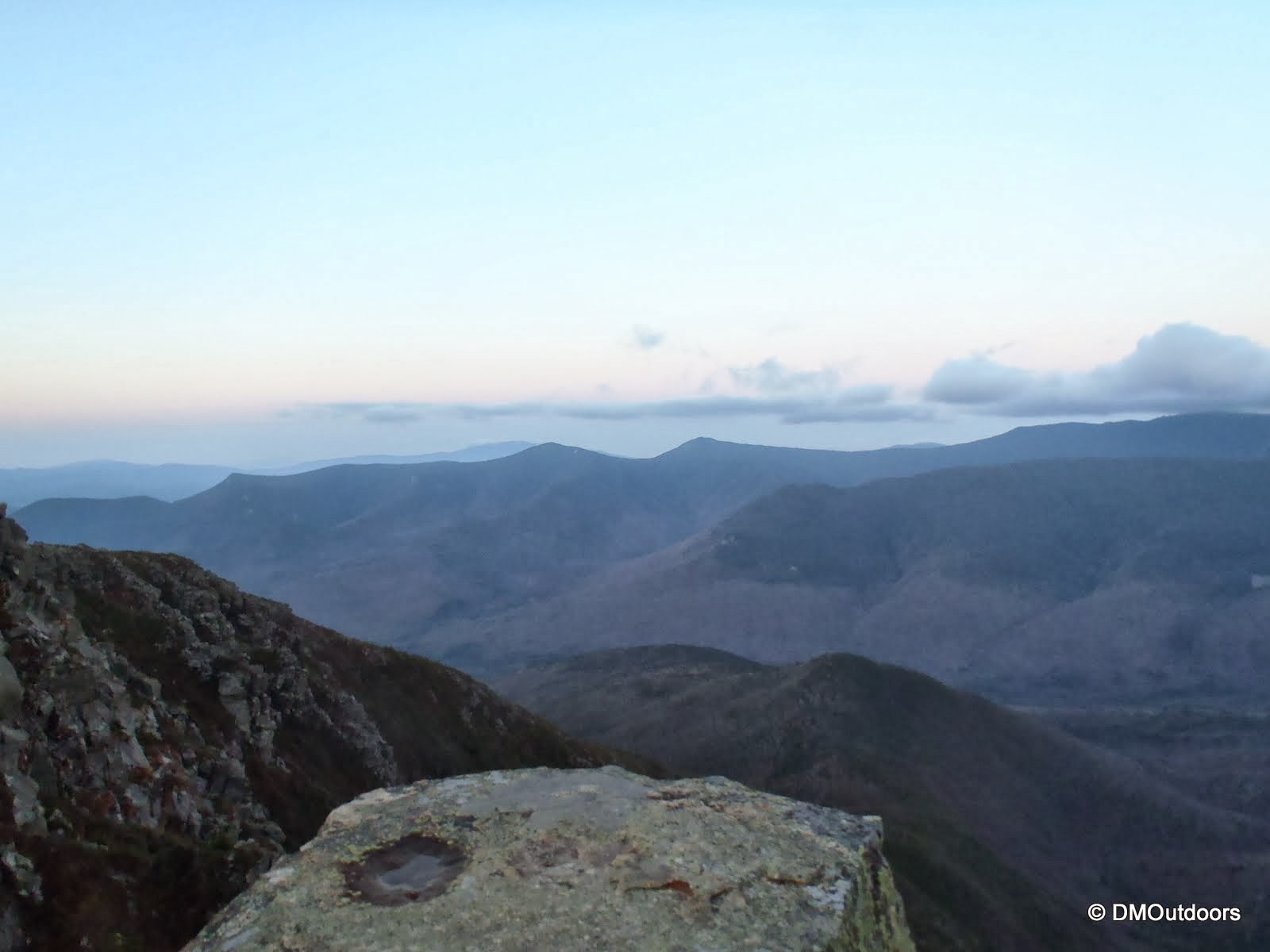
 |
| Bondcliff summit, waiting for the sun |
 |
| Bondcliff and the Bonds in front of an interesting cloud bank |
 |
| Bondcliff (It was calm, so, yes, I went and stood out there!) |
 |
| Sunrise from Bondcliff |
I was welcomed to the open and exposed alpine zone with another beautiful and calm morning, and slowly rising sun. With it so quiet, and being so far from roads, its really an intense feeling to be on the Bonds ridge at this hour. That is why I sort of slowly meandered along the ridge toward Bond, taking in the rising sun, and the alpenglow as it blanketed, and eventually fully greeted all of the Pemi peaks.
 |
| Owl's Head in front of Franconia Ridge, with the ridge to West Bond |
 |
| Sunrise from the ridge |
Eventually (and if this is going to be a 1-day thing...), I had to move myself along to the summit of Bond, where the view was spectacular as it always is in nice weather.
 |
| Classic Bondcliff from Bond shot |
 |
| Bond's summit marker, West Bond, Owl's Head, Lafayette, and Lincoln |
 |
| Bondcliff and the Pemi Wilderness from Mt. Bond summit |
With the sunrise part of the hike behind me, it was time to take on the rest of the hike, and get really moving, which lead me to my next peak - an out-and-back to West Bond's summit. It was clear with some light clouds as I reached the summit, but just a few short minutes later those clouds thickened and swooped into the middle of the Pemi, and took away the long and clear views of a few minutes ago. They were tame, but fast moving, and because of that it was sort of eerie, and made me move quite fast from the summit to the junction with the Twinway.
 |
| The last push to West Bond's summit |
 |
| West Bond offers an amazing view as your about to bag its summit |
 |
| Me on the summit, with clouds increasing fast |
 |
| Bondcliff from West Bond |
With the three Bonds behind me, I still had a long way to go, and no time to waste, so I continued on, enjoying the beautiful Twinway en route to South Twin. When I arrived, the overcast did nothing really to diminish the views. I saw the 2nd group on the day on the summit, and I was thankful for them sharing a butter-finger with me. Left over Halloween Candy makes great trail snacks! yummy
 |
| Bondcliff / Twinway Trail junction |
 |
| Arriving at the summit of South Twin |
 |
| An incredible view of Mt. Garfield and the Franconia Ridge! |
 |
| South Twin summit |
I got down the steep and rough section to Galehead Hut without any issues, but I was starting to get pretty tired considering my task. I went two weekends without hiking after the Cross Pemi hike. It was pretty quiet on the trails up to this point, around noon, and only seen a few people in about 13 miles. I decided to stop and take a 15 minute or so break with my boots off, and have a bigger snack. Along with that, a Tylenol 500 because my ankle was starting to become really sore. Right after getting started again, I ran into fellow hiker
Mike Cherim, who I've ran into a couple of times of the trail. After a nice chat with them, I was onto the Garfield Ridge Trail, with 6.6 miles strenuous miles to go until the Franconia Ridge Trail.
 |
| Looking up my path ahead on a steep section along Garfield Ridge Trail |
 |
| Looking back at South Twin from Garfield Ridge Trail, near Garfield Trail junction |
A little over 3 miles later, and including another long break at the Garfield Shelter spur to re-fill water and eat a huge cookie, I was at the summit of Garfield, which is always pretty nice. The view from the top of the Pemi ring is pretty sweet. It's a good point along the way to reflect on the madness of a Pemi Loop - on the left, what you've hiked over so far, and on the right what lies ahead, with only 2 hours until sunset.
 |
| Approaching the summit of Garfield |
 |
| Owl's Head (center), Flume (right) from Garfield summit |
 |
| 3 miles away from the start of Franconia Ridge, with 2hrs of daylight left |
The next section between Garfield and North Lafayette was much better to me this time. Garfield Ridge Trail is always tough, and I always tell myself it will be (because it is, especially going up to Garfield in both directions). Despite my progress, the soreness in my ankle (likely because of my new boots) was now a pain. It hurt more going down, and not as much going up, so I was doing alright for the time being, as I made it to treeline on the northern shoulder of Mt. Lafayette.
 |
| Franconia Ridge Trail junction |
 |
| Looking in the other direction at Garfield, South Twin, and the Bonds |
I continued on with my approach to Mt. Lafayette. I even passed a patch of snow, which helped bring a smile to my face. The atmosphere was changing pretty quickly with respect the cloud activity, temperature, and what I could see of the sunlight. It was one of the most interesting scenes I've experienced up here. The sun's rays were cool coming through the thick clouds, but the darkening sky and rapidly dropping temperature more easily won my attention, and was telling me that no matter how tired or painful my ankle was, I ought to keep my ass moving just in case this was going to be that possible late afternoon snow. After all, this is one of the most risky locations to be with weather moving into the region.
 |
| Yay my first snow this season! |
 |
| Sunset over the Kinsmans from Franconia Ridge |
 |
| Hiking into clouds on the way to Lafayette |
Always a great feeling, as it is my favorite peak, I reached the summit of Mt. Lafayette. This was my 12th summit of Lafayette. I cautiously took another quick break in the shield of the rocks at the summit so I could take another Tylenol, put my headphones away, and ready myself for the long-haul out. From here, I moved quickly (at least I thought), with my attention to the sky, and therefore less attention to my foot.
 |
| Franconia Ridge Trail (iphone) |
 |
| Here we go! A little wind, concessional snow pellet |
 |
| Mt. Lincoln summit and the last of daylight (and GoPro footage) |
So I kept on going and going, just like this trip report... As I passed Little Haystack, it started to rain. It didn't come down hard but sprinkled from Little Haystack all of the way to somewhere on the Osseo Trail. I passed the Liberty and Flume summits, and all the dark miles between. Five of the nine times I've been to Flume have been in the pitch dark. At this point, it was one last glance out at the dark view from 4000 feet and the tiny moving objects on Route 93 before a long 5.5 miles on the home-stretch back to Lincoln Woods.
 |
| Mt. Liberty summit marker |
 |
| Flume summit |
 |
| Finally, ONLY another 5.5 miles to go |
It was now 9pm, so it really took me almost 5 hours to cross the whole ridge. Counter-clockwise is much tougher, in my opinion, and I had never completed a one day Pemi Loop in this direction, so anxiousness was setting in. While the Osseo Trail is one of the easier trails, it was like torture hiking out alone in the dark, foggy mist, with an extreme pain in my ankle. About two and half hours later I eventually closed the circuit completing my 6th Pemi Loop in 20hrs and 28 minutes. It has been two weeks since the hike, and my ankle is still feeling a little weird, so I'm looking forward to getting back out there to stretch it out and to start focusing on December 21st!
 |
| The Pemigewasset River East Branch footbridge at Lincoln Woods |
Hike Stats
Trails: Lincoln Woods Trail, Wilderness Trail, Bondcliff Trail, West Bond Spur, Twinway, Garfield Ridge Trail, Franconia Ridge Trail, Osseo Trail
Distance: 31.4 miles
Elevation Gain: 10,832 ft.