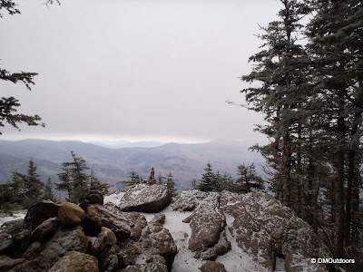
With only two more weekends left to go before the start of winter, my plan for Saturday was to hike a double hit and run of Tecumseh and Moosilauke. Winter's coming, and this entire day's goal was to make sure that my determination, drive, and ability is just as it was this time last year. Also to make sure I'm ready for the mind game of climbing up and down multiple 4000-footers in a day. Sure enough, I found that it was there.
 |
| Mt. Tecumseh / Waterville Valley parking lot |
 |
| Mt. Tecumseh summit |
Next, I hopped in the car quickly, and started my drive to the Glencliff Trail for Moosilauke, which took 55 minutes. I needed about 15 minutes to prep my pack at the trail head, but at 10:30am, I was on my way up. The lower part of the trail was free and clear of most ice. About halfway up, the ice started. Crazily, I was moving so fast, that I pushed and tested myself by not putting on the microspikes. I passed 3 groups on the way, and once onto the Carriage Road Trail, I put on the spikes, intending to have them on from here on out. It was a bit windy once on the ridge, so I had my balaclava on and heavy gloves. It was probably around 10 degrees with a below zero wind chill. Moosilauke is always great, and I reached summit where I exchanged summit photos quickly with another pair. They had come up Beaver Brook, which I'm sure was pretty icy.
 |
| Glencliff Trail to Moosilauke |
 |
| Not going on here yet in terms of winter |
 |
| Some winter here, but definitely still looks like December |
 |
| Mt. Moosilauke for the 7th time |
Total Actual Book Time: 6:42:04 (Including Drive)
GPS
The Hike Stats (combined)
Distance: 11.9 miles
Elevation Gain: 5,749 ft.
Elevation Loss: 5,869 ft
Total Hiking Book Time: 5:46:41
Elevation Loss: 5,869 ft
Total Hiking Book Time: 5:46:41
Tecumseh
Trails: Mt. Tecumseh Trail
Distance: 4.5 miles
Elevation Gain: 2,347 ft.
Elevation Loss: 2,397
Elevation Loss: 2,397
Actual Book Time: 2:10:18
Moving: 1:53:26
Stopped: 16:52
Drive to Glencliff Trail head
Distance: 43.9 miles
Drive Time: 55:54
Stopped Time: 1:34
Moosilauke
Trails: Glencliff Trail, Moosilauke Carriage Road Trail
Moving: 1:53:26
Stopped: 16:52
Drive to Glencliff Trail head
Distance: 43.9 miles
Drive Time: 55:54
Stopped Time: 1:34
Moosilauke
Trails: Glencliff Trail, Moosilauke Carriage Road Trail
Distance: 7.4 miles
Elevation Gain: 3,402 ft.
Elevation Loss: 3,472 ft.
Elevation Loss: 3,472 ft.
Actual Book Time: 3:35:52
Moving: 2:53:38
Stopped: 30:36
Moving: 2:53:38
Stopped: 30:36


No comments:
Post a Comment