Monday, April 30, 2012

Mt. Moosilauke & South Peak 4/28/12

After hiking Mt. Tecumseh earlier in the morning, I drove my way over to the Glencliff Trail to hike Moosilauke and South Peak. For those who have hiked it, Moosilauke is always great. The forecast for the weekend was pretty rough, but it turned out to be much better in terms of the amount of wind, especially by the afternoon. It was in the low 30s and breezy at the trail head, so I made sure to have my winter face protection and gloves, and an extra layer, as opposed to what I had in my pack earlier. The sun was bright and pretty warm, so as long as you kept moving it was a great day to be out.

I love the fact that on my 3rd time around, I'm still able to approach the peaks from different ways. That is only a minuscule part of what makes us crazy hikers keep coming back to the 48. At 10am, I started up the Glencliff Trail, which follows a pasture road from a parking lot on High Street. It was bright and sunny, and I was wondering how cold and windy it was going to be up top.
White blaze on the AT, near start of Glencliff Trail
Glencliff Trail to Mt. Moosilauke
At whatever elevation it started at, the trail was as nicely coated as Tecumseh from the overnight and morning snow. I only passed one couple on the way up, and once at the top, there were more hikers. It was nice hike up, but it felt much slower. I had not hiked since the weekend before the Awards dinner, which was four weeks ago. I still finished this one in 4 hours, but I'm still sore as I'm writing this. The approach is really the most difficult part. Once you get to the Carriage Road, both peaks are easy from there (pending conditions).
Trail bridge on the Glencliff Trail
The summit was spectacular. It was crystal clear with puffy clouds, and the deep blue color of the sky was just amazing. It was nice to see the snow capped peaks still. There were several groups hanging around the summit. Franconia Ridge looked just as great as ever. I could look at pictures of it all day long.
Franconia Ridge from Mt. Moosilauke
My GoPro camera is insane. It's fun. When you learn to use all of the features, the stuff you come back with is awesome. I switched the video mode to the widest angle possible, and I won't be going back. The video at the end of this report is not to be missed. I might need to go re-do a couple hikes, haha. The two pictures below are 8MP, and I can set it to take a picture every 2, 5, 10, or 30 seconds to get cool shots like these.

I hung around the summit for about 15 minutes. I sat behind one of the walls, put my bag down, and took some shots all around. There is nothing like being on the summit of a prominent peak After that, I head back the same way and scooted up to South Peak, why not get it again, right? There was no one else up there, so having a 4500' peak to my self for a few more minutes before descending is all worth it in my book.
Me on Mt. Moosilauke, with a favorite over my shoulder
Bagging Mt. Moosilauke, South Peak
The descent was pretty quick. I thought the Glencliff Trail was pretty steep, and the wet snow from being melted in the snow all day was pretty tricky. I fell at least three times on the way down. Once I nearly pulled my shoulder, and once I nearly hit my temple on a rock, its one of those close calls that make you think about the dangers out here. On the way down, it is easy to tell when it is not going to be steep any more, that was cool, because it was a nice walk out with under a mile left. My legs were toast.
Franconia Ridge taken from Route 118


Hike Stats
Trails: Glencliff Trail, Moosilauke Carriage Road
Distance: 7.8 miles
Elevation Gain: 3,300 ft
Book Time: 4hrs

Sunday, April 29, 2012

Mt. Tecumseh 4/28/12

Holy Tripoli! On Saturday, it was a really beautiful hike to Mt. Tecumseh from Tripoli Road. This would be my third time to the summit. I scoped it out that the road was open first, so I thought I would red-line the Tecumseh Trail finally and try this side, plus it is closer to the highway, and Tecumseh wasn't my only target for the day. At 6:45am, there was no else at the lot. Right away, I saw the brook at the start of the trail was just higher than all of the stones, so I had to go left about 15 feet to find a suitable spot, but I still dipped my toe a bit, but that had nothing on my brand new Keen Targhee's.
Mt. Tecumseh Trail at Tripoli Road
Brook crossing on Tecumseh Trail
Coming from this side, it was far more enjoyable than coming from the Waterville Valley side, plus you don't have to look at any commercialization. The trail was really beautiful. A fresh untouched dusting of snow sat beneath a clearing, brightening sky on this morning. I didn't mind the extra 400' up and down, actually it was a very welcomed change for Tecumseh. I was just cruising along.


I arrived at the summit, and it was windy and cold. I really liked the approach too, looking at the cairn through the trees as you reach the top. The view was incredible, especially for an overcast sky. I was impressed and pleased. I didn't linger, it was cold, so I kept moving and cruised back to the car in a nice 2hrs 8 min. It was a great warm-up for the day after 3 weeks off, because Moosilauke was next.


Hike Stats
Trails: Tecumseh Trail (from Tripoli Road)
Distance: 6.2 miles
Elevation Gain: 2,600 ft
Book Time: 2hrs 8min

Wednesday, April 25, 2012

Mt. Whitney 2012: Chapter 3: Itinerary

We are now 48 days away from our attempt to summit Mt. Whitney. Just about every single day, I add something to my planning sheet for this adventure. Over the last several weeks, and after continuing to read up on everything I can, I have compiled a pretty-close-to-final itinerary for our entire trip.

Since I posted Chapter 2, we have purchased trail maps and a couple of books on Mt. Whitney. We have also established that it will be just my brother and I on this adventure. We have confirmed our flights, and will be flying both ways together. This entire plan can change slightly, and I expect it will on the go, but its mostly set. If you have hiked Mt. Whitney, or even if you haven't, I welcome any suggestions that anyone may have or other ideas for consideration. As you will see we actually have 2 nights to spend in the Whitney area, and maybe a third. Are there any camping spots between Whitney and Vegas for Tuesday night after we descend?
Photo courtesy of George Vargas - George's Epic Adventures
Itinerary: Part One - Getting Out West and into the Sierras
Wednesday, June 13 - Sunday, June 17
  1. Take flight from Boston to Las Vegas on 6/13/12. Flight departs Boston in the early evening lands in Las Vegas after 11pm. (There will be several of my friends from HS on this flight too) 
  2. Check in to my hotel on the strip and confirm receipt of my shipped gear (stove, knives, etc), and immediately start partying!
  3. Attend wedding festivities Wednesday-Friday, and attend my friend’s wedding Friday evening in Las Vegas. 
  4. Pick up rental car from Las Vegas on Saturday Afternoon. 
  5. Depart Las Vegas by 7:00am Sunday and drive 234 miles, approximately 4hrs 20min to Eastern Sierra Interagency Visitor Center in Lone Pine, CA. 
  6. Pick up the official wilderness permit at Eastern Sierra Interagency Visitor Center. (Tentative pick-up time is around noon-time. (If, in the event we arrive after 5pm, there is a night box under a gazebo to the left and behind the building, we must contact them in advance) 
    • Ask about snow cover, trail conditions, and upcoming weather conditions 
    • Inquire about bear canister rental.
  7. Pick up any other last minute personal items, hiking items, or luxury-type food before leaving Lone Pine. If we want to have a campfire at Horseshoe Meadow, purchase our own firewood. 
  8. Follow driving directions from Lone Pine to Horseshoe Meadow Road (left off Whitney Portal Rd), and drive to the walk-in campgrounds located at Horseshoe Meadow, 10,000’. 
  9. Establish a campsite location, lock up our food, and focus on having a great evening resting, preparing, and acclimating. If time allows, take a short hike to exceed 10,000 feet, if possible.
Itinerary: Part Two - The Mt. Whitney Adventure - Day 1
Monday, June 18, 2012
  1. Wake around 6:00AM at Horseshoe Meadow, pack up the campsite, and begin our drive to Whitney Portal. 
  2. At Whitney Portal, scope out the store, grab a bite to eat, ask of any updated snow, trail, or weather conditions, and both of us will perform a thorough and final gear check.
  3. Leave Whitney Portal on Mt. Whitney Trail at approximately 9:00am, no later. 
  4. At 2.8 miles, take a short break at Lone Pine Lake at 9,900’ for pictures and to drink water.
  5. Hike 1 mile, and at 3.8 miles, take a break at Outpost Camp at 10,300’ for more pictures and water. Refill water here if necessary, and it must be treated. (If weather is questionable, establish camp and re-align the itinerary for day two.) 
  6. At 4 miles, stop to photograph Mirror Lake and the meadows below. This is treeline. 
  7. At 5 miles, stop at Trailside Meadow for a break if needed for water and to take photos. 
  8. At 6 miles, arrive and establish camp at Trail Camp, 12000’. Should we have about 2 hrs of free time and no symptoms of AMS, explore trail camp, and maybe find and sit on top a throne (hint). 
  9. Take it all in spending the evening and camping out at 12000’ - get everything ready for morning, and get as much sleep as possible, but not too much.
Itinerary: Part Two - The Mt. Whitney Adventure - Day 2 (Summit Day)
Tuesday, June 19, 2012
  1. Wake around 2:30am, eat breakfast, and plan to leave camp no later than 3:30am. The plan is to allow 4 hours to reach the summit, and be approaching Trail Crest around sunrise. 
  2. At 8.2 miles, and after the 99 switchbacks, arrive at Trail Crest 13,700’ and take a break to take in the views. Look for Mt. Hitchcock, Hitchcock Lake, and Guitar Lake, and more. 
  3. At 11 miles, arrive at the summit of Mt. Whitney. Depending on conditions, we will enjoy the summit for 1 hour. 
  4. Sign the summit register. 
  5. At the summit, look for the city of Lone Pine, Owen’s Valley, Mt. Russel, Langley, Muir, and the Sequoia, Inyo, and White Mountain Ranges. 
  6. After we’re done at the summit, we begin our descent. 
  7. On the descent, look for the Mt. Muir turnoff near the John Muir Trail junction. - Climb the class III scramble to Mt. Muir (14,015ft) and return to junction (optional, and only in favorable conditions). Mt. Muir is a CA 14,000-footer. 
  8. Enjoy the rest of the afternoon in the Sierras, and hike continuously down and out to Whitney Portal. Stop at Whitney Portal Store for some food and souvenirs. Drive to the Eastern Sierra Interagency Visitor Center to return the rented bear canister (if necessary).
  9. Getting back to Las Vegas
    • Option 1 - Drive 234 miles, approximately 4hrs 20 min back to Las Vegas and rent a low-cost room for the night.
    • Option 2 - Maybe camp out on the way back to Las Vegas? Any good ideas?
    • Option 3 - Maybe camp in the Whitney area Tuesday night, and drive back to Las Vegas on Wednesday morning or stay at a hotel near the airport.
  10. Leave Las Vegas for Boston on the red-eye. We must be at the airport in Las Vegas by 7:00pm.
That's how I plan to hike Mt. Whitney folks. At this point, the only thing that needs to be reserved is the rental car, and the only thing left to do really is buy a few more gear items, finalize the pack lists, and do a test overnight hike with all of the gear we intend to bring. Bill and I are crafting that test hike right now (in addition to other planned hikes) for the one of the first two weekends in June, and it will be another unique one, which may include Mt. Washington, Mt. Isolation and several other mountains with spectacular views. It only gets more exciting from here, and there is so much more to come from DMOutdoors this summer. In fact, somehow, I've got to finalize planning for our 4-night kayak camping trip to the North Woods of Maine. As of right now, it is my favorite place on this Earth, and I will be there in exactly 3 weeks!

Sunday, April 22, 2012

2012 AMC Four Thousand Footer Club Awards

On Saturday, April 14, 2012, the Appalachian Mountain Club (AMC) held its annual awards dinner to honor those who joined the four thousand footer club. Official AMC certificates were issued to those completing the White Mountain 4000 footers, New England 4000 footers (aka New England 67), New England Hundred Highest, and winter certificates for each of these lists.

According to the AMC committee, it was the biggest turn out that have ever seen for the annual awards. The presentation started with an incredible montage created by Nancy Sporborg and Pat Piper, who write the blog and book It's Not About the Hike. It was created from the hundreds of submissions of photos from those completing an AMC peak list. This video really captured so well the special, happy, and proud moments of many of the finishers.

Unfortunately, I did not get a chance to send in my photos, even though I finished back in August. After watching the video at the presentation, and seeing how awesome it was, I was pretty bummed to not have a picture included up there, and wish I had known ahead that it would be so good. Watching that montage brought back so many memories, and even though my first round was over in such a blur for me, it really made me think back on how difficult completing the 48 is to begin with. So for those going next year, get those photos in right away. Therefore, I just had to create my own video of my first time completing New Hampshire's White Mountain Four Thousand Footers.

(I recommend viewing in full-screen to see the text)

If you would like to re-cap by reading some of the specific highlights of my first time around the 48, click hereClick here to read about my Moonlight Presidential Traverse to finish.

I was pretty blown away as Eric Savage, Chair of the AMC Committee read many of the amazing accomplishments from the year, including that the club reached 10,000 members this October. Sitting in that auditorium as the awards are announced, it was an astonishing realization as to how many amazing, incredible, dedicated, accomplished, and genuinely nice individuals there were in that auditorium, without even knowing any of them. There were youngest and oldest finishers; there were couples; and there were entire families who completed lists. Some hikers got certificates for multiple lists. You cannot help but be inspired by everyone there. It was such a well done presentation. Once again, congratulations to everyone who received an award, and I hope to be in attendance next year, we'll see.
Me and my brother both receiving our scrolls
My scroll, patches, and stats in my case at home

Wednesday, April 18, 2012

Mt. Whitney 2012: Chapter 2: More Planning

Mt. Whitney at the time of this post! (Pacific Time)
Wow! We're two months away exactly from attempting to reach the top of the lower United States in Mt. Whitney at 14,505 feet. With our trip date coming so rapidly, I continue to move my planning forward. Mt. Whitney: Chapter 1 informed you of my successful lottery application, some general facts on Mt. Whitney and emergency information for the Mt. Whitney zone. Since then, I have been playing with my complete trip itinerary, which includes multiple days in Las Vegas prior to the hike, and also the hike itinerary itself.

In this chapter, I will be sharing some of my thoughts and notes pertaining to the weather, mother nature, and other natural factors that may affect us or better yet, make this trip as spectacular as it can be. While planning is important for the obvious reasons, but by taking notes and having everything in front of you like I do, it allows for easy decision making on the trail. Knowing a lot of about the places in advance helps create options to be able to find ways to make a trip even more memorable.

Before I get started, I'm not going to get into step by step on how to plan a Mt. Whitney hike, because there are two links you need to know to be directed towards all of the information you need to know to plan your own. Those are the forums on Whitneyzone.com and http://www.whitneyportalstore.com/. Some of those reading might think I'm missing some important things to know, but its not my intention for this to be a how-to, but more of a personal account of what I'm thinking as I plan for it, and then go out and do it.

Ok, here are the sunset and moon times for the three days we'll be focused on Whitney. At night, it will be a waning crescent last quarter moon, and each of these days we will have 14 hours and 40 minutes of daylight, which is awesome. These times are extremely important to be aware of, especially as we plan our summit day, as we'll be hiking towards the summit as the sun is rising. This also gives us a good idea how to establish our deadlines for establishing camp or potential turn-around times should we be threatened with weather or slow progress for whatever potential reason, including acute mountain sickness.

Sunday, June 17th
Sunrise: 5:34am
Sunset: 8:13pm
Moonrise: 4:05am
Moonset: 6:47pm

Monday, June 18th
Sunrise: 5:34am
Sunset: 8:13pm
Moonrise: 4:52am
Moonset: 7:37pm

Tuesday, June 19th
Sunrise: 5:34am
Sunset: 8:13pm
Moonrise: 5:42am
Moonset: 8:24pm
New Moon: 8:03am

Expected Trail Conditions
As for trail conditions, we are expecting that there be much less snow on the trail than last year at this time, but only because of the warm winter this year. But Whitney has been stormy of late, and it would not be out of the question that we encounter snow up high, or cross a snowfield.  As for the need for any winter gear, it will be monitored right up until we leave the east coast, and then we'll also ask about the conditions before we leave Lone Pine, but unless there are excessive storms this spring, we should be able to leave the ice axes and crampons home. We can't possibly know what it will be like in June, so just like I do for weekend hiking in the Whites, I'll practically be a weatherman leading up to go-time.

Expected Weather
As for the weather, we can expect mild temperatures and comfortable hiking from the portal to treeline and perhaps to the summit. While it should be comfortable on the approach, it will be much cooler up top, and any weather can lessen those temperatures. At night in June, particularly at trail camp or higher, the temperatures can dip into the 20s. It could be 50 degrees with a 40 mph, which is pretty cold.  Of course, I I hope its calm, clear, and starry, but the reality is we really have to be prepared for a wide range of temperature and the possibility of a winter storm. As for temperature extremes on Whitney, I have hiked in both colder and hotter conditions outside the entire range of the temperature extremes between low and high ever recorded on Mt. Whitney. Still, we've got to be prepared for below freezing temperatures at night, and warm weather below. This means, hats, gloves, and clothing and sleeping gear for 20 degrees, yet also comfortable clothes and footwear for warm weather hiking. The average June humidity level is pretty low, as is the average wind speeds and precipitation near Whitney.

Despite the generally low average winds, the wind can and has picked up on Mt. Whitney, resulting in many aborted attempts of wishful hikers over the years. This is not out of the question for us either. Trail Camp can sometimes experience very gusty winds, and in the past have blown away fully loaded tents of those who left them pitched as they went for the summit. This is something that we will have to keep in mind and plan for as we near tree-line. We have experience hiking above treeline in sustained winds around 65mph, but we have to realize that being at about two and half times the altitude we have ever climbed, it could potentially be much more difficult if we were to experience heavy winds.

Other potential weather dangers:
Lightning: Any sign of rain, impending storms, or lightning must be watched at all times. Common sense, and a quick review before we leave of what to do during lightning will go a long way to keeping us safe. The chances are very low, but people have died from lightning strikes in the Sierras.
Thunderstorms: There is always the possibility of a passing weather system that can produce thunderstorms, including hail. I see them come through on the webcam frequently. While the monthly precipitation in June is generally always low, the possibility always exists, which means waterproof rain gear is also an essential piece of clothing for this hike.

Animals around Mt. Whitney
The Mt. Whitney area is home to black bears, marmots, squirrels, rattlesnakes, many birds (at dusk and dawn mostly), chipmunks, deer, and also maybe...mountain lions. All of which are important to be aware of, of course.

The area around Whitney Portal has a very healthy black bear population, and will be the likely area that one could be spotted, but we don't plan to spend too much time there (maybe some last minute things or some quick pancakes), but the possibility exists anywhere there might be food, including along the Mt. Whitney trail. We know how to hang bear bags, and will be using a required bear canister wherever necessary. At the portal and established campgrounds, there are bear lockers.

The marmots are rumored to the be the most pesty animal on the mountain, stealing food right from your unattended gear or being drawn close by from the smell of food. This means we have to watch all of our food at all times.

Acute Mountain Sickness
Lastly, the most important danger that we must be ready for, is Acute Mountain Sickness (AMS). There is a lot of information available on this topic, including studies done specifically on Mt. Whitney hikers. Results of these studies show that a high percentage of hikers attempting the summit of Whitney will experience effects of AMS above 10,000 feet. This is the the biggest concern we have regarding our attempt, as we have never experienced any altitude sickness in the mountains of NH or ever. Furthermore, we have no idea how our bodies will react - will we get the typical headache, or will our bodies hate the high altitude and have a bad effect on us? This is where I see this as the ultimate test to see what our body's  limit is, and that is what I enjoy out of many of the adventures I plan. We are looking into options to camp Sunday night at around 10,000 feet so to help as much as possible, and it will also be important to keep our pace down as we climb, as opposed to the pace at which I normally climb the 4000' peaks.

Training & Conditioning & Practice
Me and my brother are not ultra marathoners, long-distance runners, or high altitude mountaineers....yet, but we have hiked hundreds of miles of trails and climbed around 200,000 feet of elevation gain or more over the last year. I recently did over 13,000 feet of elevation gain and about 40 miles in two days.

While all of the hiking I have done leaves me confident in my physical ability to accomplish this, we intend to do a couple of dedicated practice hikes on NH's highest peaks. This could include a hike in the Presidentials with our full packs, a night out at 4,000' feet or higher (won't hurt), and some sort of test run of all of our gear we intend to bring, especially the tent.

That concludes this second chapter of my planning for Mt. Whitney. More to come next on the itinerary and pack list. I just bought another pair hiking boots to start breaking in now, and I need to purchase several other things, including a new sleeping bag and maps. Man is this going to come fast. Before you know it, you'll be tracking us live to the top of the lower 48!!!

Saturday, April 7, 2012

Wildcats & Carters - A Unique Round 2 Finish - 4/1/2012


I woke around 5:30am in my car at the Pinkham Notch Visitor Center. I snoozed a little bit but, finally got myself ready as the glow of the sun splashed the mighty Washington above me at sunrise. I had hiked 21 miles the day before, and now I had an unknown amount miles to take on, but at least 14 or so and 5 peaks to complete my second round of the 48. Coming into the weekend, I decided I wanted to end on Carter Dome....somehow. As I started the day, I wasn't sure whether I was going to be splitting this into two separate hikes or figuring out a loop on the go, but off I went.

I hopped the guardrail and crossed over to the start of the Lost Pond Trail. I got to try multiple new trails this hike. The trail, which goes around a pond that's not visible from the road, was pretty neat and a little more interesting than I expected.
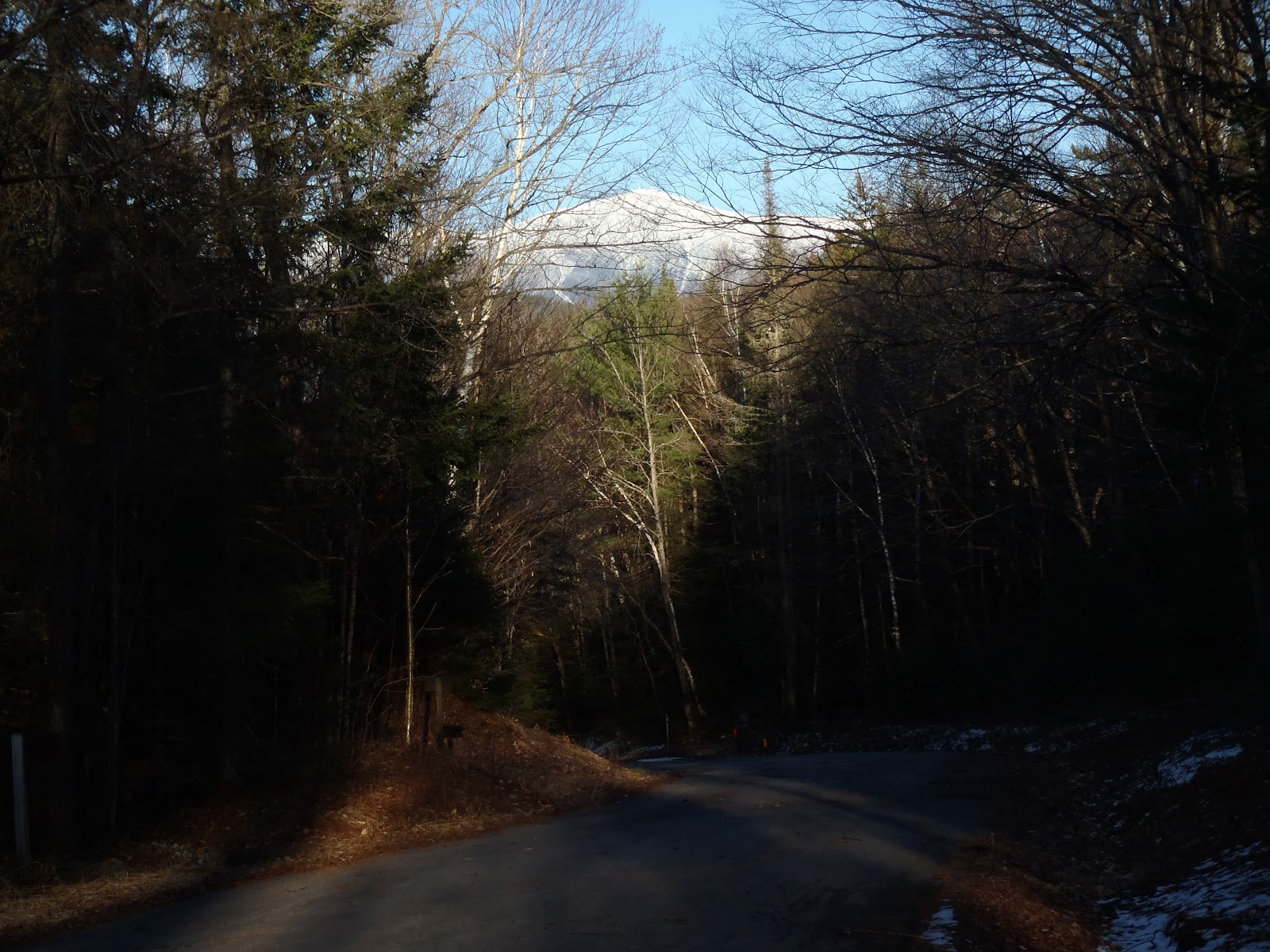
Northern Presis over Lost Pond on way to WRT
Of course I was expecting and ready for the Wildcat Ridge Trail. Somehow, to start this hike, I wasn't feeling tired at all, so up I went, and I was remembering the exact landmarks I had once passed before. The path was snow free and the climb was very fun. Before I knew it, I was already traversing the cats towards D.
Lower Wildcat Ridge Trail
Scary looking - but really fun!
Walking by a VERY steep ledge
The sun was really shining brightly as I walked the ridge over towards Wildcat ski area and the summit of Wildcat D. When I made it to the observation deck, the northern Presidentials were sitting so beautifully and the morning sun on my back gave me some warmth from the chills of the mountain air on my back which was lightly sweating from hustling up the trail thus far.
View from the summit of Wildcat D
From the trail I could see the ridge ahead and the gain to Wildcat A. It didn't take me long to get there, but it contains some small ups and downs on the way. All I remember is seeing the sign for the outlook and walking out to see my final peak, Carter Dome, beaming in the morning sun with its steep slope and rocky edges. Part of choosing to end on Carter Dome was because I really did not want to ascend that same trail from the hut below. I stayed here in this spot gazing out over Carter Notch for about 10 minutes having a morning snack and thinking of the effort still required to get there on my plan. Carter Notch is such a beautiful place in the White Mountains.
On Wildcat A, standing in front of my final round 2 peak
Carter Dome, the Carters, and the Notch from Wildcat A
As I wrapped up my break, it became decision time for the Carters and Carter Dome. Where do I go from here? How do I make this happen today? Do I go down Polecat and start a fresh loop over the Carters? Do I change my final peak, and continue a complete traverse, OR, do I just continue, diverting past Carter Dome and making this a crazy loop in one hike? I was thinking about the afternoon weather coming in and also about splitting them and getting down and being so exhausted I'd say the hell with the finish today. I didn't want that nor be starting a hike as the weather was coming in. I had packed accordingly so that I was prepared for any scenario and any decision I might make.

Off I went....down the Wildcat Ridge Trail into Carter Notch. This steep section is tough without snow, but the snow there was not very difficult for me to maneuver with my spikes, and I had descended about 1,000 feet to the trail junction in about 15 minutes. My ears were poppin' and I stood at another junction with another decision to make. This one would be the definite one that sets up the rest of the hike. Was it to go up Carter Dome right there or head down on the Nineteen Mile Brook so to skip Carter Dome and get the Carters first? If you know me by now, I'm a little wacky and decided I would head down the Nineteen Mile about 1.5 miles to hit the Carter Dome Trail up to Zeta Pass to bag the Carters.
Wildcat Ridge Trail and 19 Mile Brook junction in Carter Notch
Carter Dome Trail from 19 Mile Brook Trail
There was some ice on the upper 19 Mile Brook Trail, so I left my spikes on for the jog down to the Carter Dome Trail. They came off though before I got there due to lack of snow after about a mile down. I came to the junction, snapped the photo you see above, and quickly continued on my way...up though. The Carter Dome Trail, a new one for me, was beautiful...and mostly snow free! However, as I watched over the drainage (to see my elevation), I wondered if Zeta Pass would ever appear, but the area was just so nice - and quiet. Finally, I came to Zeta Pass now with spikes on. I love Zeta Pass because we had camped out nearby in hammocks on a great overnight traverse over the entire range on round one.
Trailside scenery heading up the Carter Dome Trail
Zeta Pass trail sign
Here I now stood at Zeta Pass in the 11am hour. I look at the sign above and remind myself that I have about six miles to get out and back to this point, and at least 10 total before I'm finished. Now, I had to bag two peaks, hiking in the opposite direction of my target destination. Having been here and traveled in this direction before, I knew exactly where I was at all times, enabling me to be on South Carter in no time. There is a step up at the summit, and an extremely small view of Mt. Washington through the trees. With not a whole lot going on there, I continued on for the longest stretch of this out-and-back, 1.3 miles to Middle Carter. Along the way over the Carters, there is rock that provides expansive views, unlike any of their summits. I could see the clouds over the Presis start to darken and move closer, about to be swallowed by them in a matter of minutes.
View from near South Carter summit
View towards NEish from rock outcrop on Carter-Moriah
Middle Carter Summit
The impending weather coming over the Presidentials
I think it was about after 1pm as I headed back, now in the direct path towards my destination. I really had nailed it on the head by getting to here by 1pm for the sake of just knowing now what I need to do and that it would likely be done before I'm in a rain/snow event on the top of a 4800' peak with a steep descent ahead. But, it was already snowing and I was chucking along back to Zeta Pass. Along this section is where I really fed off the momentum of the ups and downs. It was really fun going back and forth over the Carters. Even though I had hiked over 30 miles so far, it was as if I cruising as I was when I started the day.
Zeta Pass
At this point, it was mind over body. Leaving Zeta Pass, there was only one thing to do, and that was bag Carter Dome. The trail from Zeta Pass towards Mt. Hight and Carter Dome is a long gradual ascent of about 2 miles. Despite that and the heavy legs, I continued to put one foot in front of the other without stopping. As I neared the summit I put on the camera to capture the realism of the moment. That realism was the insane quietness, only a light breeze, the snowflakes were enormous, and it was as if I was the only person in Carter Notch. I had reached the end of my second round of NH's 48 4000 foot peaks.
The unfortunately clouded in view on Carter Dome
On Carter Dome for the end of my second round
It was great to see such a beautiful place so wintry for the last time
I was successful this weekend, and it was a really great moment, the fact that I can traverse 8 4000 foot peaks and climb 13,900 feet in about 20 hours of hiking. After all, minus the altitude, that's like hiking Mt. Whitney twice in one weekend. Having climbed all of these peaks twice, I have added grown my knowledge of the trails that traverse the Whites, and with time I will learn even more. My knowledge of what it takes and in the 15 months I have done this, I have now hiked in four full seasons through the Whites. I have been most fortunate to experience mostly fair and beautiful weather, and the challenge of hiking in bad weather is still one I look forward to and must learn.

There were many great moments through the hikes of my second round. My first Pemi Loop, my 7-year old niece's 2nd 4000 footer on Jackson on 9/11 day, Moosilauke with Owen on his quest for 48, a solo night out on Mt. Isolation, nighttime hiking, sledding on Tecumseh, glissading on the Trips, and lastly, my solo winter presidential traverse to get Jefferson. On top of that, in the same 15 months, I've already hiked 17 round 3 peaks.

Hike Stats
Trails: Lost Pond Trail, Wildcat Ridge Trail, Nineteen Mile Brook Trail, Carter Dome Trail, Carter-Moriah Trail, Wildcat Ridge Trail, Nineteen Mile Brook Trail, Route 302 to Pinkham Notch Visitor Center
Distance: 19.7 miles (not including at least 2.5 miles of road walk)
Elevation Gain: 7,150 ft
Book Time: 10hrs 30min (not including road walk )


Wednesday, April 4, 2012

Mt. Hale - 3/31/2012

It was 11:40am Saturday, as I made it back to the Ferncroft parking area after my hike to Whiteface and Passaconaway earlier. With that done, I had one more peak to bag before calling it a night and getting ready for the next day's adventure. That was Mt. Hale. From Wonalancet, I made it to the parking area across from Zealand Road on 302 in about an hour including a stop to get some more snack supplies at the Irving up ahead. I set off up Zealand Road from the lot at about 1:30pm.

By now, the day was so beautiful, bright, and sunny. I saw two women near the beginning of the road on my way in, and that was it. The road got slightly mushy in some places making it seem like a treadmill providing some resistance, but I would try to find the crunchy sparse snow or harder gravel to walk on. I made the approximately 2.5 mile walk in exactly one hour. 
Start of the Hale Brook Trail
Once past the stream on the Hale Brook Trail, there was some snow and a monorail with pretty good footing on either side of it, but it would still make me slip here and there like going up Passaconaway earlier. Hale is a pretty steep climb given the mileage, and its not necessarily very easy, but I don't recall stopping once. I noticed at how well I was doing on time, and just kept it going, one foot in front of the other to the top.
Hale Brook Trail rounding the corner near the top
The summit was spectacular. It was so bright and not a cloud in the sky. Despite no magnificent views from below the tress, it was a great hike. I enjoyed a quick snack and took in the summit all by myself for about 10 minutes. I looked up and saw the crescent moon setting among the deep blue sky.

Open summit of Mt. Hale
Me on Mt. Hale for the 2nd time (#43)
Next, I got ready for the gallop down, which went very well with no falls. The road walk was not easy physically or mentally, but I had a nice few glimpses of Mt. Washington along the way to boost my spirits. Normally, Mt. Hale is 4.4 miles and 2200ft, but this time with the road closed, its nearly 10 miles. In total for the day, I hiked 21.3 miles and 6,750 feet of elevation gain.


Since I was back to my car around 5:30pm, I had a whole bunch time to get settled for the night before my next hike on Sunday, which would be approximately another 20 miles but with more elevation gain than I just did today. That was something I was a little bit nervous of because I had not decided my exact route just yet in order to end on Carter Dome. I hopped in the car and my next stop was Gorham to get a huge meal in me for the night, some snacks for the night, morning, and hike, a couple of batteries, and some more drinks. After I picked those items up, I headed down Route 16 and car-camped it in the Pinkham Notch Visitor Center lot. This was safest lot in the area to do this, and because I was by myself with no car spot, its at least accessible for a few mile walk depending where I would end.

Be sure to stay tuned and read my next trip report on the Wildcats and Carters to see how I wrapped up this mammoth weekend hiking 8 peaks to finish my second round.

Hike Stats
Trails: Zealand Road, Hale Brook Trail
Distance: 9.4 miles
Elevation Gain: 2,950 ft
Book Time: 4hrs

Whiteface & Mt. Passaconaway - 3/31/2012

Its amazing how busy life is. My summer is booking up so fast with things to do - hiking, birthdays, parties, family get-togethers, traveling - I know I won't be hiking the next few weekends, so last weekend, I wanted to finish up my second round. So there it was, 8 mountains spread out over 3 wildernesses on the docket, requiring at least 3 separate hikes and two days to do it. I didn't add up the elevation gain until after - who cares, it had to be done anyways. One thing I decided was somehow I would finish on Carter Dome - Not an easy task when you still have to hike the Wildcats and Carters.

I got a 6am sharp start at Ferncroft Road on the way to Whiteface and Passaconaway. It was pretty mild to start, and I expected the temperature to remain consistent through the day. It was very comfortable. The trail below was clear, and snow and ice started to become a factor after the tricky section of ledges. Towards Passaconaway there was definitely much more ice as you will see below.

As I made it to the first open ledges, the sunrise was beautiful despite the overcast skies. I made it to the most notable ledge and began the tricky section up towards the top of Whiteface. It is such a fun climb, and that along with the beauty of this area makes this a great hike all around, despite the lack of expansive views.

With Hale to climb later in the afternoon with a long road walk (I was dreading), the focus was to keep moving. It took me 5hrs and 40min to complete the loop, and with very few breaks, I still managed to have all of the fun you see me having below.
Me on Whiteface summit (#41, round 2)
Dicey's Mill Trail heading to Passaconaway
Presidentials from Passaconaway viewpoint
Path to Mt. Passaconaway high point (#42, round 2)

Hike Stats
Trails: Blueberry Ledge Trail, Rollins Trail, Dicey's Mill Trail
Distance: 11.9 miles
Elevation Gain: 3,800
Book Time: 5hrs 40min