On Saturday, June 1st, I challenged myself to complete my 2nd One Day Extended Pemi Loop. This variation of the Pemi Loop is 38.6 miles with 10,800 feet of elevation gain, and goes over twelve of the forty-eight White Mountain 4000-footers. The "Extended Pemi Loop", I call it, adds Zealand to what is known as the "Fancy Pemi Loop" as described oin
David Albeck's guide to the Pemi Loop. Certainly, doing an overnight Pemi Loop in harsh conditions with a 35+ lb pack the weekend before did wonders for me on this one with the lighter pack, but by no means was either of these adventures easy.
In order to set up myself for a hike like this, my pack is completely ready to go Thursday night, minus water and my snacks. I drank about two liters of water on Friday at work, came home cooked some stuff up on the grill, and was in bed around 6:30pm for a few hours. I woke up at 10pm on the button, drove north, and at 12:10am, I was zooming into the Pemi Wilderness on the Lincoln Woods Trail, right on schedule. There's not a whole lot of time to spare on this hike in order to get it done in a day.
I was off flying with the lighter pack, and in the blink of an eye, the Osseo Trail was behind me and hit the summit of Flume once again in the dead of night two hours from the start. The birds were already chirping in the night as I reached the ridge, a sign of a beautiful day to come. The temperature at the start (and right over the Franconia Ridge) was comfortable, with that nice layer of perspiration forming on my skin.
 |
| Approaching the summit of Flume |
 |
| Summit of Flume at night |
The .6 mile section between Flume and Liberty now seems so short to me. A half hour later, I was on Liberty, snapped a quick foot-on-the-summit shot, and off I went. There's really much else to do at this point other than take a sip of water, look down on the lights in Franconia Notch, and keep going to maintain a solid time.
By doing these back-to-back Pemi Loops, I was able to even more-so stamp in mind the trail features of certain sections along this hike, like the next section on the Franconia Ridge Trail. In the winter, a heavy-leaner can block the path and confuse you, and the Franconia Ridge trail after the junction with the Liberty Springs Trail has a few twists and turns that are really good to remember, especially for the winter for that reason. Despite that thought process going on my mind, I was still cruising this nice flat section, and in three hours and about 20 minutes, I was on Little Haystack. Here, I noticed the waning crescent moon had risen in the sky behind me.
 |
| Franconia Ridge Trail and Liberty Spring Trails junction |
 |
| Little Haystack summit |
Here I was, once again traversing the Franconia Ridge in the moonlight, like I did at the end of April. Now, as wee hours turned into morning, the light of day started to creep in from the east. All I could think of was that there is nothing better than watching the sunrise over the Pemigewasset Wilderness, something I've seen many times now. It's such a vast view, and when you have in your mind that you're going to traverse all of it in a day, climb all of those mountains, is extremely motivating (and fun!).
 |
| Mt. Lincoln's summit cairn as I approached (look closely) |
 |
| The moon over the Pemi |
Increasing in elevation, I made my way over Lincoln, North Lincoln, and up the summit cone of Mt. Lafayette, still before actual sunrise. This was my 10th ascent of Mt. Lafayette, and it was just as rewarding as last weekend and my first time. The weather was beautiful, and the blue and purpl-ish color of the morning sky over the Pemi was awesome. I arrived at the summit to find a pair of hikers with a pair of dogs and a solo hiker on the summit. One of dogs was very friendly, but had a small cut, and on request, I provided an antiseptic wipe and band-aid from my first aid kit to her owner. I stood up on the highest point for a few minutes admiring the Pemi and chatting with one of the hikers. I opened up a snickers, and before I even finished eating it, I was snacking and skipping my way down Mt. Lafayette's northern shoulder.
 |
| Mt. Lafayette summit pre-sunrise |
 |
| My 10th time to Mt. Lafayette |
 |
| A plane's trail reflects brightly off the sun above Garfield and Twins |
 |
| A final look back at the morning moon over the Pemi |
Now on the Garfield Ridge Trail, it is 2.9 miles to the next summit, Mt. Garfield. This part of the hike was probably the most peaceful part of the entire day. Birds greeted me at treeline, and it seemed like the woods were waking up for the day. However, its not an easy section - there is a ton of descent over rocky and rooty trail before a quick steep climb up to Garfield. The photo below is a great shot of what it looks like looking back at Mt. Lafayette, now close to 3 miles back.
 |
| Looking up to Lafayette on the Garfield Ridge Trail |
I reached the vacant summit of Garfield where I had extensive views into Pemi and a look back at my route so far that day. The skies were crystal clear and blue at this time. It was beautiful. I sat next to the summit and had a quick snack here. Mornings are always great on Garfield.
 |
| Mt. Garfield Summit |
 |
| (Left to Right) Flume, Liberty, Lincoln, Lafayette |
 |
| Pemi Wilderness (Owl's Head on Right) |
After my break, I began my trek along the next 3 miles of the Garfield Ridge Trail. This is the part of the Garfield Ridge Trail that holds all of those pointless up-and-downs, and side-sloping rocks en route to the Galehead Hut. The first quick stop was at the Garfield Ridge camp site spur, where there is a water source. Although my bladder was still pulling water, my stop here was to apply the awesome cold water on my face and arms a couple of times and continue. The temperature was very warm and humid, but at this point it was not yet oppressive or affecting me - it felt so refreshing, just like mountain water always does. On I went.
 |
| Garfield Ridge Trail towards Galehead Hut |
 |
| Garfield Ridge Campsite water source |
Thankfully, this section is broken up by two trail junctions, otherwise it would feel like forever. Still, not much else to do then to push for the hut, and that's what I did without stopping. I arrived at the Galehead Hut, walked right past it, and continued right up to the summit of Galehead, which I've now reached 8 times, each time a different month.
 |
| The beautiful view from AMC's Galehead Hut |
 |
| Galehead Hut with Galehead summit in background |
 |
| Big smile for being on Galehead in about 8.5 hrs from Lincoln Woods |
After getting down Galehead after a few short minutes of rest on the summit, I popped into the hut where the new caretakers where getting ready for the first full service evening of the season. I had stayed here the weekend before this hike when it was not in full-service. I filled my bladder, and also filled my water bottle with a little bit and mixed a Cytomax packet in. This stuff is kind of nasty. I'll stick to Gatorade mix, I think. I just had a couple left in my food stash. I gulped on that steadily all of the way to North Twin before getting into my full 2L of water again.

The hike up to South Twin was next - .8 miles and 1,100 feet of elevation gain, one of the steepest sections on the whole Pemi Loop. It has become second nature, almost, and I no longer dread it or complain about it. I think of it as a natural stairmaster, and just program myself to keep a steady pace, doing just that, one step after another without much stopping. Before I know it, I'm passing the North Twin sign on the way out there.
 |
| North Twin Spur |
 |
| North Twin - a 2.6 mile out and back with 750 feet of extra gain |
Just as I skirted around the rocks of South Twin's summit, something startled me, and I turn around, and there is a rabbit just a couple of feet in front of me! He poked around looking at me, approaching me, wondering if I was going to give him some of the nutter butters I just happened to have in my hand. He didn't take the piece I threw to him, but he did hop the heck outta there and down the North Twin Spur. I could see him hopping along the trail up for 50 or so yards along the trail corridor. It was like he was going to bag North Twin too! I scurried along, wondering if I'd see him again.

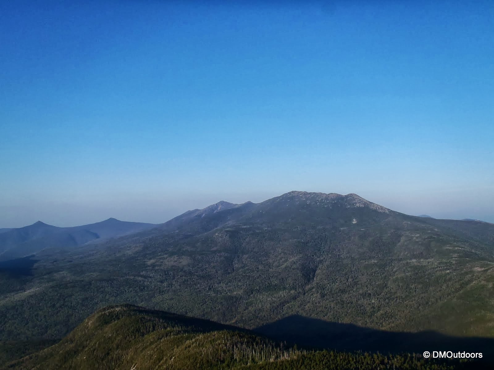
I made it to North Twin's summit outlook, and took about a 10 minute break here, with my boots off (which I did about 4 times on this loop, something I've never done before). This was because I kept getting dirt and twigs in my boots. I opted to keep my low gaiters off until later when I would put them on. A young couple was kind enough to take my photo at the outlook. The photo at the top of the post is from the North Twin summit outlook. It's a beautiful view, one that puts into perspective the varying elevation of peaks on the northern part of the loop.

I hiked back up the North Twin Spur and right over South Twin again and onto the Twinway. It would be 2 relatively easy miles (after the steep descent into the trees from South Twin) to the Bondcliff junction from here. At this point in time, you have to prepare the mind for one more pretty difficult out-and-back to Zealand, in terms of mileage and gain together, before you can think that your now on more direct path to the end. Up and over Guyot, one of the coolest spots in all of the White Mountains I went. The Twinway en route to Zealand is quite rocky and gravel-y, and doesn't make this out-and-back and easier, especially at this point along this extended loop. Nothing to do but keep going, get there, take a picture, and turn around.
 |
| The Twinway leaving South Twin summit towards the Bonds |
 |
| Owls Head in the foreground with Flume, Liberty, and Lincoln in the back |
 |
| Mt. Guyot Summit |
 |
| Zealand Summit sign |
That I did. Zealand was my 9th 4000-footer of the day, and with just three more now not too far away, I was feeling pretty good. My feet were starting to get real sore by the time I reached the West Bond Spur. It was here that I bumped into a big group, which consisted of several folks from the 4000 footer group on Facebook, who were doing a Zealand-Bonds Traverse. While I past them on my way out to Zealand, it was this time we acquainted. Nice to meet Monica, Joe C., Michael B., and others in that group. Both myself and this group were on the look-out for another fellow hiker, Bill R., who was also attempting a Pemi Loop, starting approximately 3 hrs after I did. This would be around the location we'd expect to bump into him, but unfortunately, his journey turned out differently (but not disappointingly). You can read his well written account of how his journey ended up, by clicking
here.

After a chat with the group, I headed out to West Bond, the very last out-and-back on this journey. What a different world it was here compared to the weekend before. Instead of a socked in view with rain and iced over trees, I was treated to a nice breeze, 360 degree view of the Pemi, and the always impressive view of the Bonds ridge line. 7 times, 7 months now to West Bond, one of the most remote and challenging peaks to get to in the White Mountains.
 |
| The Bond's ridge line from West Bond summit |
Now, I was officially on a one-way path to my destination. Mt. Bond was next, the highest peak left before I started to finally descend in elevation. I quickly snapped a few photos and continued down the Bondcliff Trail towards the exposed ridge. This section is another tough-go with hopping over large rocks being required all of the way until it levels out about halfway across the ridge. This is very tough on the feet at this stage of the game, but being in the presence of such dramatic landscape such as the Bonds, it kept me going - one more peak, and then I'm outta here.
 |
| Mt. Bond summit |
 |
| View from Mt. Bond |
 |
| A black and white take on the view of Bondcliff from Bond |
 |
| Heading to Boncliff |
A little more slowly now, I made my way up the last bit of elevation gain to the Bondcliff summit. I just snapped this picture below and continued on. Now with all 12 peaks successfully reached, all that was left was my descent down the Bondcliff Trail, and then a long flat walk on the Wilderness Trail and Lincoln Woods Trail. Although sore at this point, I was still able to jog some of the clear and gradual descent sections leading to the bottom of the ravine at the sharp turn. At this point, it was starting to spit rain, but that's all it did, thankfully.
 |
| Bondcliff summit |
The walk along the Wilderness Trail back to the Pemigewasset Bridge near Franconia Falls was very pleasant despite the growing soreness in my feet, of course. It's really a different world with everything grown in compared to months ago. Finally, I reached the bridge, and with my feet pretty much screaming, I decided to head to the bank of the river, and relieve my feet. I took off the boots and dipped my feet in the ice cold river and instantly they were numb! After this, I dried them off, threw on a pair of fresh dry socks, back on the boots, and now just a few more miles to go and done!
 |
| Wilderness Trail |
The Lincoln Woods Trail, now, was nothing like the Wilderness Trail. Although I had put on a long-sleeved shirt, I left my pant-legs off. Whether I walked as fast as I could or even jogged or ran, both mosquitos and black flies were taking chunks out of my legs. This was completely driving me insane, but it forced me to run, power walk, run, power walk, for 3 miles until finally the A-frame sign came into view, and then finally the suspension bridge. I was done - 38.6 miles, 10,800 feet of elevation gain, 12 4000-footers in just under 20 hours, matching the longest day hike I've ever done.
 |
| Lincoln Woods suspension bridge |
 |
| The Spot Track of the Extended Pemi Loop |

Completing the Extended Pemi Loop is definitely a rewarding experience. Visiting one-quarter of the 48 4000-footers in a single day, and seeing the different views from all of those points along the way is certainly memorable. I reached every summit, each out-and-back, without removing my pack, which had the Spot Messenger attached to it. It was just under 20lbs including 2L of water). In total, I drank about 6 liters of water, and had several candy bars and snacks spaced out throughout the day - nutter butters, snickers bars, Slim Jims with cheese, crackers, and the Cytomax drink. After doing a counter-clockwise overnight Pemi Loop the weekend before, and this one being a clockwise loop, I am now even more confident in my knowledge of these trails. I did all of this without even needing to consult my map (although I would never go out without one). With this hike in the books, I've added 12 June peaks to my 48x12 Grid. No longer is June the month in which I've hiked the least 4000-footers!
Thanks for reading! Stayed tuned....another milestone is coming up in two weeks as my brother and I get ready to finish the New England 4000-footers on North Brother in Maine. It will be the first time we'll finish a list together, and what better way for us brothers to finish on North Brother.
Hike Stats
Trails: Lincoln Woods Trail, Osseo Trail, Franconia Ridge Trail, Garfield Ridge Trail, Frost Trail, Twinway, North Twin Spur, Bondcliff Trail, Wilderness Trail.
Distance: 38.9 mi.