Thursday, July 28, 2011

Bondcliff, Bond, and West Bond 7-23-11

Rays of sunshine from Bondcliff Trail
Well, it was a great weekend again. Starting with the weather and the mood Friday afternoon as we drove up to our camp, as we planned to hike the 3 Bonds on Saturday. Friday night called for a nice evening meal and beer at Shooter's Tavern in Belmont, followed with a couple of bottled waters, then it was off to sleep for a few hours.

Trail sign at Lincoln Woods
A few hours it was, and we were off and walking past the Lincoln Woods Visitor Center at 2:45am. You might say yikes, but it was well worth it. Headlamps and flashlights ready to go, we crossed the bridge and headed down the Lincoln Woods Trail, the old railroad beds. After hiking in the night two hikes in a row, I can honestly say that if your lost at night with no flashlight, there is nothing you can do but just sit there until tomorrow. Always bring a flashlight! We shut off our lamps to check it out a couple of times and were pretty humbled. We continued down the trail, and I think we might have seen only one of the many campsites along the way in use. The river flowed loudly below us on the right for a while. We passed the trail junctions to Osseo, Black Pond, and the bridge near Franconia Falls, making it to the Wilderness boundary.

Wilderness Trail
On the Wilderness Trail, after the initial narrow section widens to railroad grade again, we may have had our first wildlife encounter, but we don't know what it was, even shining our flashlights in the direction of it. We were walking, and with our headlamps we noticed two really bright reflective objects, and Bill immediately assumed it was the side of a tent at tent site. As we continued along the flat trail, the two things disappeared and appeared and we stopped. We shined the flashlights on the area at the same time, and we saw 2 slow blinks come over these bright objects, but could not see what it was, as it was around 100 feet off the trail, up an embankment. We thought it might be an owl. The eyes were 2-3 feet off the ground max, and were bright white. It didn't seem to move or bother us, but it was quite interesting. We swiftly booked it along the rest of Wilderness Trail, and then to the Bondcliff Trail.

Bondcliff Trail nearing summit
Here, it finally started to ascend. It was still pitch black for a while on the trail, but the sky was slowly starting to get lighter as we continued. At the earliest we could, we killed the headlamps and allowed our eyes to adjust. The trail makes a hard turn with slight views of the valley, and the rocks of Bondcliff are slightly visible at the top.  The trail continues to ascend. It's rocky and the footing is often tough. Eventually, the trail gradually comes out of the trees and to a couple of different rock scrambles, then its flat as you walk towards the cliff where there are incredible and steeeeep views into the wilderness. Owl's Head seems so close in the foreground. Franconia Ridge soars on the other side.


Approaching the summit of Bondcliff
Next, it was time for our pictures on the cliff. This is a very nerve-racking moment, there's no question about it. There is no coming back from any mistakes up there. What a thrill for my 38th peak of the year.


It was 6:50am, we had made the 9 miles to Bondcliff in about 4 hours. Just as we finished with our photos, it started to drizzle, and it looked liked weather was moving in. We put on our jackets and headed on the trail towards Bond. Up here the footing is sometimes unstable, and requires hopping large boulders. We moved along with no issues taking in the above treeline walk in the spitting rain, which was amazing.

Bill takes his 20th peak
We made it Bond, which was Bill's 20th 4000 footer this year with me. The views remained tremendous, and we could thankfully see the weather system passing to the South, and it the weather only got better from there. We enjoyed the views for a few minutes and decided to continue on towards West Bond. Again, the greenery along the ridge trails is so nice. It's hard to believe you can find such flat sections of trail up that high, but I love it. Not only is the flat trail a relief, it feels like your in Avatar for a few minutes haha.

Grouse blocking Bondcliff Trail
Just before the West Bond Spur leaves on the left, we ran into something blocking our path. It was a grouse. Both Bill and I have had encounters with these. I nearly stepped on one while running down the trail on one of my hikes, it started squawking and flying down the trail in the direction I was going, I didn't know what to do, so this time, we just slowly approached, and a loud step made it go on its way without incident.

The West Bond Spur was easy, with one scramble near the top. On my 40th peak, I had views back to the other rocky Bonds and Guyot, S. Twin, and Garfield, which I had done the week before. Not only that, we stopped for about 10 minutes and split a full orange for a snack. Not only that, the sun was breaking the clouds, which was awesome.

Bondcliff as seen from West Bond
Back on the Bondcliff Trail, we could start to feel the heat of the sun. It was already warm so it didn't take long. We stopped for a couple quick breaks on the way back to Bond for water and some Trail Snacks. The views were even better as we peaked Bond again. The view of the surrounding mountains and the straight line of the ridge is impressive.
View from Bond of the Bondcliff Trail and surrounding wilderness
From Bond, we cooked it along the ridge to Bondcliff, in fact we covered a bulk of the distance in about 8 minutes, as shown in the video below. Back at Bondcliff, the wind was light in spurts, but still easy enough to pose for our pictures again, this time in the sunshine. :)


After Bondcliff, it was back into the trees and down. On a hike like this, there is no escaping the feeling of a dreadful hike back. When will the Bondcliff Trail end? When will we get to Franconia Falls, and then walking in pain the last 3 miles or so past the many folks enjoying their day hikes with family along the popular section of trails.

When we finally made it back to the car at 2:45, there was plenty of time for, and no hesitation with, throwing on our bathing suits and plopping ourselves into the cold and refreshing East Branch. What a way to end one of the best hikes of my journey.


Here is a video presented in 720p HD showing the highlights of our experience :


Hike Stats
Trails: Lincoln Woods Trail, Wilderness Trail, Bondcliff Trail, West Bond Spur
Miles: 23
Elevation Gain: 4500 ft

Also, be sure to check out the full album from this hike.


Wednesday, July 20, 2011

Garfield, Galehead, North & South Twin, & Zealand 7-17-11

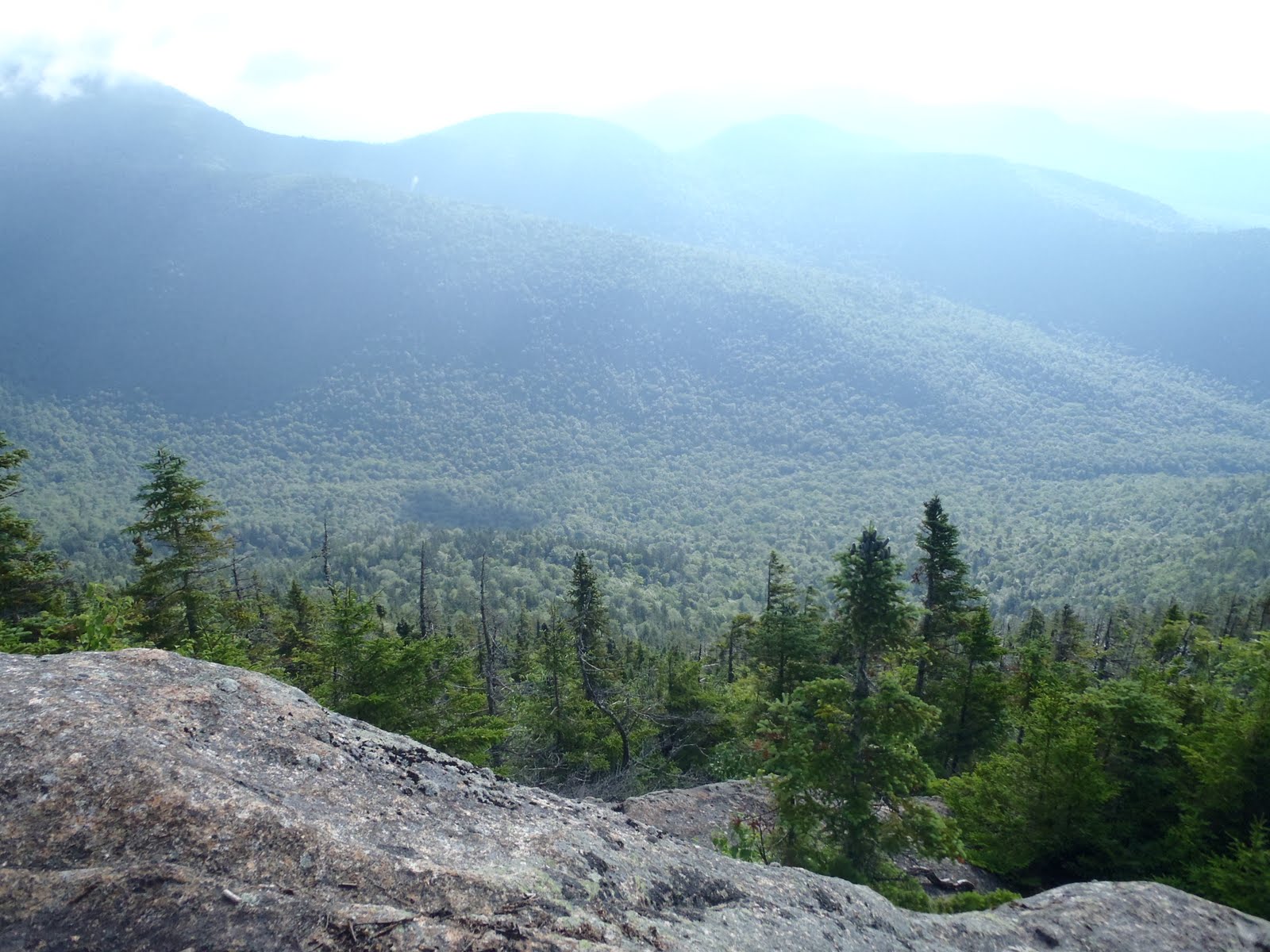
Owl's Head and the Pemigewasset Wilderness from Garfield
So it was 8:20 pm on Saturday, and I had just finished my hike to Mt. Carrigain. Once I got to the parking lot, light faded fast, so I quickly decided that tomorrow I was going for as many as I could. During the week, I was considering several different options to hit the remaining peaks along the Pemigewasset Wilderness. Since I didn't have a car spot this weekend, I decided that I would start with Garfield and the Garfield Trail and see how far I could make it before I had to get back to either Gale River Trail or the Garfield Trail.

After 9pm there was no action in the parking lot so things were quiet. I had some food and soda I had in the car so I was comfortable. I cooled off in the AC for bit, changed into some extra clothes, and listened to some music and prepared my pack for tomorrow's hike. The bugs were fairly oppressive during the hike and still at the car, so I didn't really feel like setting up the hammock outside. I decided to try to get some sleep in the car. It actually wasn't too hard to fall asleep, and when I woke up a few hours later at 2am, I realized I actually had a good nap, and was ready to go. With everything in my pack already set, I left Sawyer River Road in the middle of the night and headed up 302 to Route 3 to the Garfield Trail via the Gale River Loop. Along the 20 minute ride, I saw 2 fox alongside the road. I found the Gale River Loop Road gate closed on the Garfield Trail side, so I had to turn around on 3 and go back a few hundred yards to access the loop road by the Gale River sign and drive almost the full the loop to the Garfield Trail.

Headlamp on Garfield Trail sign
I had been set on starting at 3am, because I really wanted to be up there by the time the sun rose. I've hiked in the dark before a few times. Most memorable was the time my brother and I visited the Deboullie area in the North Maine Woods. My means of light were my Princeton Tec Fuel Headlamp and my Brookstone Waterproof LED Flashlight. With the lights out, I have to admit I could not see ANYTHING. I used the headlamp mostly and supported it when needed with my Brookstone flashlight. By the way, I highly recommend this flashlight.

My middle of the night walk up the Garfield Trail was completely uneventful. I maintained a steady walking pace, and only recall stopping for some water on a couple of occasions. The streams at the beginning were low and were no problem at all to see and cross. There was only one really large blow down that blocked the path of the trail on the other side of a crossing. After scanning the river bank for a few minutes, I saw the path beyond the horizontal limbs of the tree, which extended fully across the path. There were no unusual noises or anything that concerned me as I ascended.

I made it to the junction with the Garfield Ridge Trail, and then proceeded to approach the summit as the sky went from black to dark blue. The first and only rock scramble indicates your just about to the summit. It was around 5:30am, so I was where I had hoped to be at that time. As I came out of the trees onto the ledge, I noticed a few people were there already, as they had camped out in the box at the top. (BTW, what the heck is that thing?) Anyways, the air was heavy and warm as its been lately, so I was sweating. As I set my pack down, it was necessary to throw on my jacket to stop the immediate chill, but had to be careful none of my gear blew away in the whipping wind. I still don't know which I enjoyed more, the view of the days first rays to the east, or the morning moonlight over the Franconia Ridge. I'll let you ponder that one.


Galehead Hut
I took several photos before heading back down to the junction. I took a right onto the Garfield Ridge Trail towards Galehead Hut. At times, the hut is visible way up on the hill from the trail, but with the Gale River Trail junction in between, it didn't really seem that bad, its flat at times too. By the time I reached the Galehead Hut, the sun was out and bright. I hiked right past the hut and proceeded up the Frost Trail to the summit of Galehead, my 34th peak. Although the hut has great views, the summit cairn a half mile up is surrounded by trees.  After a couple pictures confirming the summit, I headed right back to the hut. The hut was bustling with everyone eating their breakfast and gearing up to head out wherever. I re-filled my water and was on my way like no even knew!

This for .8 straight
The Twinway Trail begins right near the hut, and heads towards South Twin. This .8 mile section up South Twin felt like forever. Not only that, its pretty relentless in terms of the trail's steepness and rockiness. Eventually, the summit appeared quickly as I came out of trees. I had reached my 35th peak.
Looking towards N. Twin

After exchanging picture duties with a couple on the summit, I quickly continued and headed out on the North Twin Spur. This trail was nice and flat so I was off and running. It was a half hour, and I was at the summit view point of North Twin, again enjoying sweeping views of Franconia Ridge and the peaks I just came across. Looking back at South Twin, it seems like the trail would be steeper, but that's not the case.

I love ridge trails
I made it back to South Twin and located the Twinway that descends the summit towards Mt. Guyot. After an imediate and brief steep section, the trail levels out very nicely. Along this section, a couple of water breaks had me pass a girl who appeared to be around my age a couple of times. I tend to keep quiet, but I finally asked where she was headed, and she informed me she was thru-hiking the Appalachian Trail (AT). In the 45 miles that I have hiked along the AT so far, this was my first meeting of someone who was doing it. I was quite surprised that she was by herself and from Minnesota. She planned to finish within a couple of weeks. We hiked together about a half mile or so chatting a bit and we eventually came out onto the exposed ridge at the Bondcliff Trail junction.

Zealand summit sign
Knowing that I would be coming back to this junction, I took off up the Twinway over Mt. Guyot. The 1.3 miles from here to Zealand seemed long. With that being the case, I was really trying to make good time in this section. I made it to Zealand in just about a half hour from the Bondcliff Trail junction, just what I wanted. A couple of young wiseguy kids on the way said the view was tremendous on Zealand. I just laughed to myself knowing the summit would be wooded with no views. Zealand was my 37th peak, and 5th 4000 foot summit within a span of about 5 hours. Again, another couple of photos and back I went on the Twinway towards Guyot. I passed the girl again in between Guyot and Zealand and wished her the best of luck as she finishes the AT. I was intrigued by that experience, and I would love to do it someday.

When I made it back to the Bondcliff Trail junction near Mt. Guyot, it was just about 12pm. It was now decision time about whether to go for the Bonds or not. I wasn't sure exactly how many miles I had done so far, but I will go through my decision making process. I know it was only 12pm and had plenty of time to fit them in, but I had to remember what I did yesterday, and that I started at 3am, not 7, 8, or 9 am. I had filled my water last at Galehead Hut and knew there wouldn't be any water going over the bonds. Secondly, I had some trail mix and 2 energy bars left, which was not a whole lot. Thirdly, I considered what I would automatically be facing on the way back (pic below), and that was the ascent and descent of South Twin. Lastly, my motivation was raging, but my legs were screaming, so with that and the other concerns, I opted to turn right and head back up the Twinway.

Twinway towards S. Twin from Zealand (on the way back)
Things went slower but smoothly as I made my way back to Galehead Hut. There were only a couple people in the hut now, and I re-filled my water again, I was out. On the counter were some chocolate cakes and some sort of apple crumbles or something. I had to have one, so I paid a dollar, along with a couple dollar tip for one piece. I mowed it down as I walked out onto porch of the hut. Had to taste that cake with a view. It must have been the best piece of chocolate cake ever. It did give me a bit of a boost as I hopped on the Garfield Ridge Trail for a quick .6 miles to the Gale River Trail junction. At the end of it all, I knew there probably wasn't much of a difference from choosing the Gale River over going back to the Garfield Trail to descend, but I was opting to exchange Garfield Ridge Trail mileage for Gale River Road mileage.

Gale River Trail near the Garfield Ridge Trail junction
Once I hit the Gale River Trail, it was a long 4 miles to the trail head. I passed several hikers hiking up for the night. The trail is relatively easy and follows the Northern part of the Gale River for most of the way, which was pleasant, but at this point it was a bit of labor to push along. I stopped to refresh my face in the cool mountain water that was crystal clear. That kind of helped me through the last mile or so of trail. Once onto the road, it was at minimum a one mile walk along the road between the Gale River and Garfield trail heads. I finished just minutes after 4pm.

The road was not relief, I didn't remember at 3am it was all hill
What an incredible day it was to cross 5 more peaks off the list. This hike was 25 miles over 7,050 feet of elevation gain. If you combine this with my hike of Mt. Carrigain on Saturday afternoon, that is 35 miles over more than 10,000 feet of elevation gain within a 24 hour period. It's hard to believe these stats myself. Despite the quickness at which I might be able to hike, its not hard to remember every single second because the views and overall experience of being in the mountains seems to make time stand still.

Hike Stats
Trails: Garfield Trail, Garfield Ridge Trail, Frost Trail, Twinway, North Twin Spur, Twinway, Garfield Ridge Trail, Gale River Trail, Gale River Loop Road
Miles: 25
Elevation Gain: 7050 ft

I encourage you to check out my album on this one.


Tuesday, July 19, 2011

Mt. Carrigain 7-16-11

Another unique approach was in order for my 32nd peak of my quest for 48. With an appointment for work in the morning this past Saturday, I planned to start some sort of hike by mid-afternoon. I changed and hit the road up route 93. My plans were still uncertain around 1:30pm when I met my brother who was at our camp near Tilton. We met at a nearby pawn shop to check it out. They had a couple of nice canoes out front. The main reason I was meeting him was to get a rainfly to use as a tarp in case I decided to camp out.

So its about 2pm and I'm headed up 93, still unsure what to do. I don't recommend anyone follow this method, but at this point, I'm thinking about what mountains are next as soon as I'm finished with the last one, so by mid-week, I've already read the guide and calculated all of the mileage and elevation, not to mention probably at least 4 other blog posts with trip reports. I decided on Mt. Carrigain by the Signal Ridge Trail. It was exactly 4pm as I started up, and I was excited to be heading up later in the afternoon, like a said, a unique approach thus far. 

With a good chunk of the trail at the beginning nice and flat, I picked it up to a light jog. It became a more gradual ascent after leaving the junction with the Carrigain Notch Trail. The cliffs of Mt. Lowell began to tease through the trees as they become thinner.


Unless you stop to take a rest, it's just a few minutes until the trail finally breaks out onto the ridge with incredible views. Unsolicited, a young boy with his family informed me that the summit was about a half hour more. I actually thought I reached the summit, but then I saw the observation deck. 


So I headed up the trail and was at the summit in about 15 minutes. The views were incredible, and I had a blast identifying the Hancocks, Trips, and of course Washington. In fact, 43 of the 48 4000 footers are visible from Mt. Carrigain, except I'm not good enough to point every single one out, just good enough to hike them all, and experience it all. As I near the end of this quest, I'm really starting to get the 360 degree views.


I met a nice couple around my age at the summit who were camping the night. I noticed many trail side camp sites, including a set of tents about a mile in from the start, so this must be popular. They had a bottle of whiskey and we're kind enough to share a couple swigs. I stayed for about a half hour and we talked some hiking. You might notice I didn't take many pictures on the summit. I think its because I saw so many mountains, I didn't know what to do, except enjoy it.

Brook crossing near the end, still light
The descent was straightforward. I stopped for a couple of minutes on the exposed ridge, this time no other people, to watch the sun go down a short distance. As I descended, the sun started to fade more behind the ridge. I actually passed the family that gave me the half hour heads up, and I also passed another woman who was going down both times I saw her; the second time, she asked me if I had gone all of the way up. She said it was one of her first times hiking, and she asked me about the family being up there after dark. I suggested that the family probably hikes often, and if they didn't it was a relatively easy trail. She didn't seem to have very much gear herself, but I walked the last half mile or so with her out to Sawyer River Road. It was 8:20pm. If you take out my much enjoyed half hour break at the summit, it took me just under 4 hours. I was figuring I would be using my headlamp, but not the case.

Well, I was back at the car, but I didn't leave to head home or to head back to camp. To find out what I did next to continue my quest, you'll just have to read my next post. But if you would like to view my album view or click the slideshow below.


Hike Stats
Trails: Signal Ridge Trail
Miles: 10
Elevation Gain: 3250 ft

Wednesday, July 13, 2011

Mt. Whiteface & Mt. Passaconaway 7-9-11

View from Ferncroft Road
This weekend was a great weekend! The weather had been great leading right into the weekend, so it was a relief to be able to waste no time in getting up to NH after work. After all, this weekend was a family weekend at the lake, so again, Lake Winnisquam was base camp the night before our hike. This time, we were able to hang out with family across the lake. Bill and I didn't stay up all night Friday night. We got a good few hours of sleep and then we found ourselves standing at the base of a picturesque Whiteface and Passaconaway from Ferncroft Rd. at 6:00am sharp.

Immediately, I sensed something different about the area. I think its different than the more northern 4000 footers. There is something about the houses, the land, the hiker friendly signs, and just the views. What a place to be. The air was pretty thick, so it was already warm. Everything was pretty wet still, so there was a little concern about the ledges being tricky, but off we went following the signs to the Blueberry Ledge Trail. Everything was well marked, so just explore around down the road and you shall find the way.

Finally on the trail, we experienced some rocks and wet roots basically, but nothing too difficult for a while. The morning sun's rays were coming through the trees, which really made it enjoyable.


You immediately know when your approaching the south ledges of Whiteface when the path turns into slabs. The sun continued to increase and gave a nice shine as it came over the tree tops. The views started to appear just as it got much steeper. We were looking forward to these rock scrambles. There is a section of trail near the beginning of the ledge that turns right to go up, but has a ledge to the left that must be more than several hundred feet down. This section was still wet with trickling water and had our full attention.

Not necessary to risk getting any closer...
We continued up the ledges using the finger holes where they were. We found that we had to use them, and I actually had to trust my finger in the hole with risk of falling, except falling was not an option.


Me on the summit of Whiteface
After the couple really steep parts, the ledges continue, and you just want to keep on taking more and more pictures, but we said the hell with this, lets get to the summit. So we did, and we found the cairn at the summit of Mt. Whiteface and had a quick break on my 30th peak of my quest. Despite the steepness and great views that slowed us, we were making good time.

On the Rollins Trail, we quickly moved over the ridge headed to Mt. Passaconaway. Ridgeline trails are incredibly fun to hike, and this one didn't disappoint either. Sometimes along the way, the trail hugs a steep section and provides a great view of the The Bowl. The Bowl Natural Research area is an area between Whiteface and Passaconaway that has trees up to 400 years old and has no recorded history of logging or wildfires. Marked on the map, we looked it up, and knowing this made it even more enjoyable. There are not many areas like this left, no matter what region your from. Time on the Rollins doesn't go by super fast; it feels like a while before you see Passaconaway get closer. We eventually passed a junction and began the climb up Passaconaway.

The climb on this section is continuously steep until the summit. There is a view point before the summit that gave us this tremendous view.

There is a sign pointing to the summit, which is a short trail going up to a slightly higher but flatter area. There were some sticks on the ground that were clearly not natural, so we assumed it was the summit, and my 31st it would be.
Me on Mt. Passaconaway
Again, ahead of schedule, we were anxious to continue on and get back down quickly. We descended via Dicey's Mill Trail and arrived back at the car at 12:10pm, finishing the 11.9 miles and 3800 ft of elevation gain in 6 hours, 10 minutes.We started early so that we could get back down quickly. That's because there was great food and family waiting back at the camp. We were back at the lake to go for a quick tubing ride before a feast of steamers, lobsters, and mounds of other food.

Hike Stats
Trails: Blueberry Ledge Trail, Rollins Trail, Dicey's Mill Trail
Miles: 11.9
Elevation Gain: 3800 ft

To view the full album of selected photos, click on the slideshow below.

Tuesday, July 5, 2011

Wildcats, Carters, and Moriah

This Fourth of July weekend took me, my brother Bill, and our friend Sean to the mountains for an overnight traverse over the Wildcats, Carters, and Mount Moriah. The stats of this trip are impressive at 6 peaks, 18.2 miles (13.7 on the AT) and about 6900 feet of elevation gain, which is more gain than what is required to climb the highest peak in the lower 48. But more impressive were the views and the experience of hammock camping at 4000 feet on a beautiful night.

Ellis River crossing
We arrived at the Glen Ellis Falls trail head around 7:30 and we took a walk down to see the falls before setting off. My dad joined us to the falls and back to where we would cross the river. The river was easily cross-able, and I wasted no time getting the hike started by jumping the rocks, going across the purposely placed log and to other side. We waved bye across the river, and the Wildcat Ridge trail immediately begins to ascend, and before you think there is any break, it gets even steeper, going up very challenging slabs. Along the way on one of the ledges, we came across a garter snake that darted out from the rocks, making itself known. Finally we reach Wildcat E, and it gets a little easier as we made our way to and past the chairlift to the summit of Wildcat D. On the observation tower, the Northern Presidentials loomed over us like giants in the hot morning sun. It was a great backdrop for my halfway point of this quest for NHs 48, my 24th peak of the year. We took a much needed break and soaked in the view.

Wildcat Ridge Trail
Vertical section of Wildcat Ridge Trail
Me on Wildcat D, my 24th peak - halfway done

The 2 mile section between Wildcat D and Wildcat A is only slightly easier. The trail continues to ascend to the summit of Wildcat A. The view point over Carter Notch,near the summit of Wildcat A, provides one of the most tremendous views I’ve seen. The hike down to the hut is very steep. Once we could see the water of the lake through the trees we were relieved to take another break at the hut to refill our water and have some food.

View of Carter Notch from Wildcat A
View of Carter Notch from Carter-Moriah Trail
In the top center, look closely to see hikers at the Wildcat lookout
The Carter-Moriah Trail from the Carter Notch Hut to the summit of Carter Dome was the most strenuous section of the entire hike. Although we weren’t going up rock slabs, there was absolutely no break in the ascent. The heat of the day and already having gone up the Wildcats and down over 1000 feet to the hut, certainly makes this section already more challenging then it is as it lies. On the way up, the look back over the Notch is just impressive. We could see hikers at the Wildcat view point, and it’s incredible to see (and experience) how high and how steep it is up there. We finally made it to Carter Dome just after 4pm.
Me at the cairn on Carter Dome just before the clearing
The view from Carter Dome
We had passed the halfway point of this traverse, which was our goal for the day. We continued on the Carter-Moriah trail to the junction for Mt. Hight. Mt. Hight is said to have the best views of this hike. We had just tackled the toughest part of our hike, going up several thousand feet and also going down over 1000 feet. Since it was after 4, we knew the extra half mile, including extra elevation gain, would take us longer at this time of the day, therefore we agreed to skip Mount Hight and continue on to find a suitable spot to camp. It will be there for another day, and there was already no disappointment in the views.
Ray of sunshine over the western slope of the Carter Range
We came to Zeta Pass where it said no camping, so we re-filled our water using our Katadyn water filter, and continued further along the trail and found an area to explore. We bushwhacked over a few small hills that brought us to a relatively flat area well off the trail near the eastern slope. We were pretty tired. We set up the hammocks and cooked our dinners away from camp on the stove and ate a much needed bunch of calories. Dinner (for me) was a 2 serving beef teriyaki and rice. We fended off the flies as we ate. It was nearing 8pm as we finished cleaning up our dinner stuff and hanging the bag. Bill and I gave cheers on this great hike with a little bit of Glenlivet before settling into the hammocks and getting some sleep. Bill and Sean had no problem sleeping, but it took me a while. There was a cool breeze all evening, it was a perfect night, so who cares if I didn’t get much sleep.
Our hammock set up
Sunrise through the trees from our camp location
I know I got some sleep because I was awoken by Bill just before 5, and we began to break down the hammocks. Each of us made our freeze-dried breakfasts and prepared to ascend South Carter. At 5:30am, the weather was already very warm and still calm, as it was all night. Shortly, we arrived at the wooded summit of South Carter, my 27th peak.

The section of the Carter-Moriah Trail between South Carter and Middle Carter has countless open viewpoints, either to the east or to the west. It was constant picture taking of the purple mountain majesty before us. Continuing on and ascending a bit more, we passed over the summit of Middle Carter at 4610 feet. After that, we were still getting great views as we descended Mt. Lethe to the North Carter Trail junction. We were planning that here, Bill and Sean would head 4.5 miles down the Imp Trail to Route 16 because they were running out of gas and didn’t want to push on the remaining distance, which was 8.5 miles. We left my brother’s Jeep at Bangor Street in Gorham, so he gave me his key, we reviewed the map, and parted ways.

Can't get enough of this
Bill and Sean admiring the Northern Presidentials
The trail going down from North Carter was very steep. It was a very long and careful descent of 1.9 miles to the Imp Shelter. After the Imp Shelter, there were a few close junctions that made it feel like I was getting somewhere. On the way to Moriah, there are rock slabs that require momentum to get up and still ledges providing views all around. I finally made it to the junction and saw the trail sign for the Carter-Moriah Trail. I climbed the vertical rock, .1 to the summit of Moriah. It was exactly 10am as I reached my 29th peak of the year, and my 6th 4000 footer on this hike. It was completely silent and the clouds were moving in. I took a moment to rest since I had a strong pace since I left Bill and Sean. I had some combos and water and I charged my cell phone with my battery charger so I had some juice in it before getting to the car.
Me on the Carter-Moriah Trail
Summit of Mt. Moriah, my 29th peak of 2011

I then headed down the Carter-Moriah Trail, 4.5 miles to go to the car. I was surprised at how much of this 4.5 miles was still over rocky trail and above treeline. It felt like I was never going to descend, and then before even reaching Mt. Surprise, it started to rain. This immediately made the descent more challenging because the trail consists of a lot of rock. The descent is more gradual here, but man is it a long trail at the end of a hike like this. Finally after Mt. Surprise at 2160 feet, the trail began to descend below treeline. It was still pretty challenging, and unlike many of the lower sections of other trails I've done so far. Still raining, I was just pushing and pushing my way down, and finally, I bolted out of the woods onto the dead end of Bangor Street. Bill had called only 10 minutes before I got to the car. They had set up their hammock to relax for a few at the Imp Trailhead, but it began to rain, so they took shelter in the woods in their rain gear until I got there just a few minutes later.


This was an extraordinary hike, requiring great effort, and the views made it more than worth the effort. I’m still struck when I look at these photos, especially the ones looking back at the mountains we had just came over. I have crossed 6 great 4000 footers off my list, and I’m excited to be a whole lot closer to my goal.


Hike Stats
Trails: Wildcat Ridge Trail, Carter-Moriah Trail
Miles: 18.2
Elevation Gain: 6900 ft


To view the full album of this hike, click on the slideshow below. When looking at this album, two cameras were used, so they are not in complete order.