Showing posts with label Travel. Show all posts

Saturday, November 1, 2014

Mt. Rainier 2014: Exploring the Pacific Northwest

I knew last year that this summer I was going to be climbing Mt. Rainier, but come June, I did not have anything booked yet.  If I was going to go for it, my next biggest climbing goal, its simply up to me to just do it.  I watched as some of the climb dates with RMI slowly start to fill up.  It was mid-June when I pulled the trigger and booked a final spot on a Labor Day weekend climb with RMI.  Just like that, I was going to climb Rainier, and within a few short weeks I had my complete plan in place to fly out to the Pacific Northwest and join RMI for a 4-day program and 2-day summit attempt of Rainier.
(Click Here to read my first post and full adventure plan.)
This was the first time that I've ever flown alone, out of 4 round trip flights in my life.  It was going to be an adventure for sure.  I left Boston at 7:00am on Friday, August 29th, and enjoyed a nice flight into Portland, Oregon.  I flew just above the clouds for the entire route across the country, over the mountains of the mid-west, and saw Rainier and Adams just before landing.  It was pretty eerie going in for the landing through the clouds, the tarmac showed just a few seconds before the wheels hit the ground.  I don't know how the pilot saw the runway.  Anyways, and there I was in Portland, Oregon.
Leaving Logan
Sea of clouds
Mountain ranges
Rainier in the back, Adams on the right. 
After arrival, I retrieved my rental car for the week from Enterprise.  I was being offered a pick-up, a suburban, and a couple of others, but I asked about and retrieved a brand new GMC Terrain.  I drove a GMC Terrain when me and my brother went out to Mt. Whitney, so I lucked out, taking a car I've used before.  Although it would have been nice to see Portland a little bit, I drove right up to Ashford to the Whittaker's Bunkhouse.  That afternoon, I checked in and settled in.  I reserved a one-bedroom with private bathroom for 4 nights in a row, plus 1 night after my climb.  The room consisted of a double bed, two nightstands, alarm clock, ample lighting, and a full bathroom with a really hot shower.  Everything was clean, every day, and it was pretty much worth the $90 per night. That night, I did supper simple, and walked next door the Basecamp Grille and had a bacon burger, which was small but very good. 
GMC Terrain rental car
Whittaker's Bunkhouse & Motel - Ashford, WA 
Bacon burger from the Basecamp Grille
Although I did have most of the day after I arrived, I had decided to take it easy because of the cloudy, drizzly weather.  I basically settled into my little abode to plan out the next day, which I had a full day to do whatever.  I woke up the next morning (a Saturday morning) and enjoyed a coffee outside the bunkhouse cafe, not knowing what the day ahead really held for me.  All I know, was that I was going for a little road trip of exploration, so off I went.


I was eyeing a few possible hikes to do before I started the climb program.  One I was reading about is Mt. Wow (6,040'), which is a bushwhack from a nearby forest road.  The first thing I did this day was take a ride up the road to scout out the start of the hike.  The road was fine for a while, but it got pretty rough and steep.  At the end of the road, as I had read, I came to the spot where the supposed bushwhack starts.  Its kind of crazy being across the entire country, alone, at the end of and up a mountain forest road that's only wide enough for the car, and just drive-able enough. So I had scoped out this starting spot, but it certainly looked as if it was a bit too difficult to get into with my limited time the next day. Its cool to know for next time. Don't bother asking any locals about Mt. Wow, they have no idea where it is. Some info on Mt. Wow.

The start of the bushwhack to Mt. Wow, Goat Creek on left.
4 miles up a mountain road
I then drove the approximately 4 miles back down the main road, which goes into Rainier National Park.  Then I drove right past Whittaker's, and took a state highway north, headed towards Olympia, setting off on my road trip for the rest of the day.  I drove past the Capitol Building in Olympia and through the city, headed west.  Driving in the Pacific Northwest was amazing, with its super tall and straight pines.  When you see a logging area in Maine or something, it has nothing on the logging swaths which I saw while driving west toward the coast.    
Washington State Capital 
Typical highway in Washington State
I continued west and found myself in Aberdeen, WA.  At that point I was seeking a spot to take in the Pacific Ocean for the first time ever.  I seemed to notice that there wasn't really any beaches, so I knew I had to dive a little bit more south.  I looked at my navigation on my phone, and figured Long Beach would be a good target.  It took me about an hour or more to get further south, so it was interesting leg of the road trip.  I would later find out from talking to a few people that Aberdeen is considered one of the dumpier towns in Washington.  Nobody goes there. haha.
Long Beach, WA 
Long Beach, WA panorama
Eventually, I made it to Long Beach, which was a nice beach town.  It reminded me of Old Orchard, but without as much bustle and no attractions.  I parked as close as I could, and made my way out onto the beach.  The beach was beautiful and extremely large in size.  It was quite exciting, even by myself, to jaunt out to the water's edge, and step foot in the Pacific Ocean for the first time.  

The moment my feet were in the Pacific Ocean for the first time 

After spending at least a half hour or so out on the beach, I figured I would keep on trucking along my road trip loop.  I was 150 miles, and 3 hours away from Ashford.  I didn't really expect this, but as I head back out of Long Beach, I found myself at the Columbia Bridge and the Columbia River.  What an intense spot. 

Columbia River from the Washington side. 

Driving over the Columbia Bridge
I pulled off to the side next to the bridge to check my navigation, and to take a few pictures of the river and bridge.  Little did I expect, I was crossing back into Oregon, and almost near Portland again.  What a trip this was! I drove a little over 300 miles, all day long, and had quite an experience seeing some of the area.  It was a little cloudy that evening as I made my way back to Ashford.  I pretty much just missed everything nearby closing at 8:00pm, so I had to go back out about 7 miles to Pizza Express, where I indulged on a delicious large pizza to my face. 

Pizza Express 

The next day (Sunday), I had the climb orientation at 3:00pm in the afternoon.  I woke up, got some coffee and packed a super light pack for a quick hike.  I drove back up the forest road I scouted out the day before, but this time, I continued up a different fork in the road to the trail head to another peak, Mt. Beljica (5,475').  Looking for something short to hike to get in the rhythm, I had looked it up.  Again, no one around Basecamp had seemingly ever heard of Mt. Beljica (literally 4 miles away), so could not offer me any tips when I was asking for short hike suggestions. 
Whittaker's Bunkhouse & Motel Cafe
Mt. Beljica is just a short 1.4 miles  and 1,100 foot ascent from the start of the Christine Lake Trail.  There was a simple sign-in and forest permit form, which I attached to my pack.  I started up the trail, and began my first hike in the PNW, and right on the edge of Rainier National Park.
   
Christine Lake Trail 

Entering Glacier View Wilderness
The trees were huge, the trail was flat, and it was quiet and beautiful.  I entered the Glacier View Wilderness, and in just a few short minutes, came over a little bump and rounded the shores of a beautiful Christine Lake.

Christine Lake
Getting the heart rate up, I sped up the easy trail, hooked a left where there was a spur for Mt, Beljica,  The Christine Lake Trail continues on to the right for some distance.  I hopped up a rooty and eroded path, and broke out onto an exposed summit.  I head towards the highest point, and quickly realized I was on a dramatic summit with at least several hundred foot drop-off to one edge, and a pretty intense weather-y view out over the mountains near Mt. Rainier.  The cloud cover was too much to see Mt. Rainier or any glaciers, but it was an intense feeling of risk there up on the top rock of the summit, where there was a marker. A surprise for sure, and a tremendous feeling of excitement as I was back at home (over 4,000 feet) and in just a few short hours, I would be meeting my climbing team and guides.

Mt. Beljica summit marker 
Steep summit perch 
View from Mt. Beljica

The hike was a total of 2.8 miles, 1,100 feet of elevation in an hour and a half.  I drove back down the crazy mountain road, and got ready to go to the RMI climb orientation.  All this excitement, all this experience, all of which was going according to plan, and I had yet to set foot on the slopes of Mt. Rainier.  That would all start to take place shortly.  After meeting the team and guides for introductions, I decided on a solo full course steak dinner and local beer at the Copper Creek Inn & Restaurant.  The server was as friendly as could be and the food was simply excellent.  I even had their signature blackberry pie.  Feeling full, happy, and excited, I returned to my room for the night, as tomorrow, I would set foot on Mt. Rainier, and start preparing for the biggest climb of my life.

A narrow section along the forest road
Steak from Copper Creek Inn & Restaurant 

My next Mt. Rainier post will be the trip report on the mountaineering day school, and my experience climbing to the summit of Mt. Rainier with RMI Guides over two days.  Stay tuned!
Summit of Mt. Beljica (5,475')

Wednesday, July 4, 2012

Death Valley Tour 2012


On the way back to Las Vegas on June 20, 2012, which was the day following our summit of Mt. Whitney, we took a tour of Death Valley and many of its sights along the way. Death Valley was such a desolate place, an amazing place, and I was able to get a sense of how it is place where it is tough to survive.

We left Lone Pine on Route 136/190 towards Panamint Springs. Then on Route 190, we made our way towards Stovepipe Wells.

Stovepipe Wells Visitor Center
At the visitor center, we went into the store to buy Gatorades and water and see what the gift shop was all about, and we were looking how to pay our entrance fee. The girl at the counter directed us to the ranger station which was in the lot next to the store and gas station. Here, we met a ranger inside who took our fee and provided us with a map and permit for our vehicle, and we were on our way. Man it was hot outside.
Stovepipe Wells Ranger Station
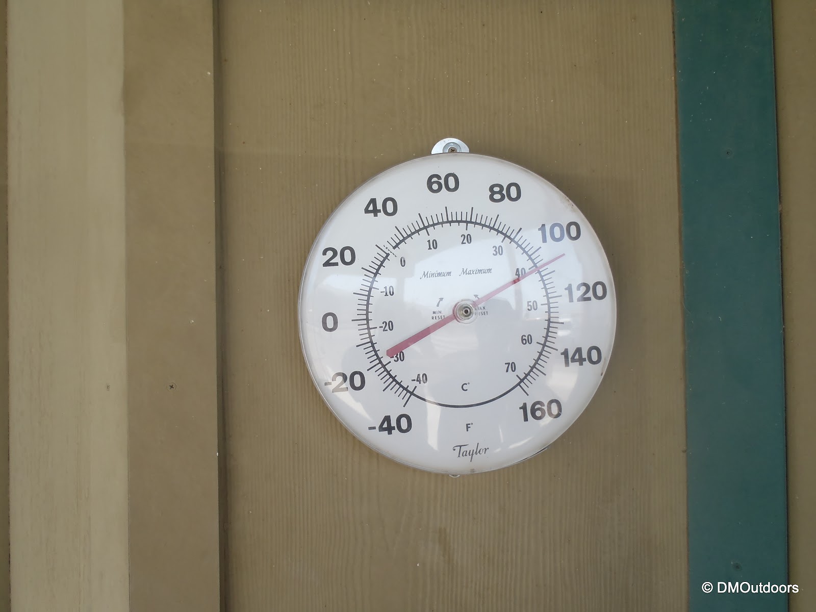
Thermometer outside of Stovepipe Wells Ranger Station
Mesquite Sand Dunes
Very quickly after the visitor center lies the Mesquite Sand Dunes where there are pull-offs on the road, and its not too much of a signed area, but we pulled of, wanting to take a walk towards them off the road, watching for snakes as we passed each bush. We were now expanding this incredible trip into an even greater adventure I never expected. Later, I'd read that these sand dunes have been used in Hollywood films such as Star Wars.
Mesquite Flat Sand Dunes 
Bill exploring Death Valley
Me in the middle of the desert!!!!
Continuing East on Route 190, the next major town is Furnace Creek. After Furnace Creek, in order to experience this grand tour, don't miss the turn onto Badwater Road, Route 178. It starts and ends on 190 between Furnace Creek and Shoshone, driving south, at the base of the Black Mountains to the left. Very quickly, we saw our next destination of choice, Golden Canyon.

Golden Canyon
At Golden Canyon, there is a large parking lot, and a trail head information sign. It looks like a wall of mountains with a path leading into a Canyon. I didn't know what to expect reading the sign, but we grabbed our cameras and water and took off up the trail. There were several other people exploring, as well. The trail winds up the canyon, and we looked all around to see impressive rock formations displaying many layers of rock. I am not sure how long the path winds up the canyon, but we only went about a third of a mile before turning around and heading back to the car, but so far I've hiked off the road into the desert and also into a canyon a little bit, this is crazy!


Artist's Drive and Palette
Around 6 miles south of Golden Canyon was our next interesting feature to explore, which was Artist's Drive and Palette. The sign said "No Vehicles longer than 25 feet", but we were all set. The reason is because the road to and from this spot has such severe dips so that if you have a long car, you could get stuck by your front and rear bumpers, haha! From the highway you can see the attraction, which is a display of layered rock in several colors, which is caused by oxidation of certain metals in the rock. This area was highly volcanic thousands of years ago. The road is a few miles long and is just as fun as seeing the main attraction.

Artist's Palette seen from the viewpoint on a hill a short stroll away
We have to give it up to our GMC Terrain, which we chose as our rental out of the available fleet from National Car Rental of McCarran Airport in Vegas. It struggled in terms of power and sometimes acted weird, but it was new and looked pretty good everywhere we went. Having this rental was an added element for me, being in control, doing whatever the hell we wanted miles and miles away from home. This is something that I've wanted to do, and want to do. Just get on a plane or in the car and go, and experience first-hand new places and going at it with no holding back.
Our GMC Terrain rental car and Artist's Palette
Natural Bridge
Just the name itself was reason to make this a definite stop. We arrived, and went over to look at the trail head sign. It was a 1 mile hike to the Natural Bridge through Natural Bridge Canyon. Would we do it? Would we ever get to do this again? Hike 2 more miles in the desert? Of course we did it. It was blazing hot still, now around 110-115 degrees as we were getting closet to the lowest elevation. We checked our water supplies, put on sunscreen and grabbed our hats before setting off with a steady pace and deep breaths. It was just like Golden Canyon, but a little bit wider. Quickly, we noticed that it didn't seem that bad, as we could see the bridge, which was mighty impressive. We got a little bit closer and noticed that a mountain is visible above looking through underneath it. It offered a little bit of shade for us too. The trail extends much further past the bridge, allowing for more hiking, but another one mile back to the car, which would be enough satisfaction for us after being able to see the Natural Bridge.
Looking at the trail ahead from the near the lot. 
Walking into Natural Bridge Canyon


Badwater Basin
Next, was our most anticipated destination on this journey, Badwater Basin. Badwater Basin is 282 feet below sea level, and is the lowest place in the United States and in all of North America. We had just come from the highest elevation in the lower United States to the lowest in North America. This was such an amazing experience. Badwater Pool is fed by a spring nearby, and up on the side of the mountain, across the road was a sign labeled "sea level." That was pretty cool. I can't count how many times I've heard about this place, and now I've been here, after climbing to the highest.
Badwater Basin 
Me and Bill at Badwater Basin, -282 below sea level 
Badwater Pool
Sea level sign at Badwater Basin
The trip lost a little bit of momentum after Badwater Basin as we passed the desolate Mormon Point, where the road rounded about the ridges extending to the desert floor from nearby Smith Mountain, 6000'. We also saw a sign for Manly Lake. Tens of thousands of years ago, the valley we stood in was filled with water to about halfway up the mountains we saw. That was amazing to see and think about.
Passing Mormon Point
Lake Manly - it must have looked amazing way back then
Ashford Mill Ruins
Our last destination, 30 miles from Mormon Point, was the Ashford Mill Ruins. This place of importance has a rather simple and interesting history. Long story short for you - it was someone else's property left over from the gold rush, and someone came along and found a little bit of gold, and after a dispute it turned out the prior owner didn't keep up on his stuff, so the new guy got to keep it, and then the site changed hands twice and was developed into a mill. The reason it lasted so long was because they accidentally trained in twice the amount of cement needed to build the mill. It was a very pretty place, with nice mountains surrounding it.


After Ashford Mill, the road heads into the Black Mountains where you pass through Jubilee Pass and Salisbury Pass and descend into Shoshone. Salisbury Pass is at over 3000 feet of elevation.  After leaving Shoshone, we got stuck at a road work stop for over a half hour. Road work in the desert is a little bit more difficult.
Waiting for road work after leaving Shoshone
After that restless ordeal, we were on our way out of Death Valley and out of California. California was an amazing place, and there is much more I want to see, both cities and mountains. We had about the same distance we just drove to go again before getting back to Vegas. There, we would end our amazing and unforgettable trip, having partied it up in Las Vegas with friends, climbed Mt. Whitney camping above 10,000 feet twice, and then just going all out on Death Valley.