Saturday, January 29, 2011

Gear Page Update #1

I decided that I would inform you of my gear page updates as posts so that my readers will know when I make an update to that page. As I've stated on my My Gear page, I'm hoping to be able to show a picture or video of each product in use. This is basically a fun addition to my site, and I hope to continue filling up that page with links.

Today, I've added 3 videos to my gear page showing the use of Kahtoola Microspikes, the Keen Targhee II Mid hiking boots, and the REI OXT Tech Tee.

The Keen Targhee Mid II Hiking Boots are great. They are very lightweight and are waterproof. I have used these in spring, summer, and fall, and have also hiked in a few inches of snow with them. The waterproof capability of these boots is great; I can only recall a few times when I noticed my sock getting wet. The video below shows them put to use on the Rocky Branch Trail in October of 2010. The trail was basically a river, and while I successfully rock-hop the trail in this clip, you can see my boots are soaked and not slowing me down.


I got the Kahtoola MICROspikes for Christmas this year, and I can see what all the craze is about. These things are fantastic when it comes to climbing up an icy mountain. On New Year's Eve this year, I hiked Mt. Monadnock, using the spikes for the first time. The trails were packed out below, but the ice on the top of the mountain made it necessary for me to have these on. Right away, I could feel the power these things have. This video is a great example of the ability of Kahtoola's Microspikes.


The REI OXT Tech Tee comes with me on every single trip, whether its kayaking, hiking, or working outside. Its basically my first layer, unless I have my REI base layer on. In the video below, I am wearing it as I paddle with my brother down the Pow Wow River. Its comfortable and airy, and keeps me dry, and also dries quickly.


If you have not checked out my gear page, please do, as I already have some cool videos and pictures of me using my gear. I'm certainly open to any questions or comments anyone has on these products. Enjoy!

Monday, January 24, 2011

Mt. Tom - January 22, 2011

On Mt. Tom, near the summit
After hiking Mt. Tecumseh the day before, the plan for Saturday was to hike Mt. Tom, Field, and Willey. However, the hike from yesterday took a toll on each of us, and we did not wake up according to plan. That cut a few hours off, resulting in us only going for Mt. Tom when we reached Crawford Depot. Although we got a late start, we were apparently the first on the Avalon trail. The guys at the lodge registration said the trail was nicely packed out, but that wasn’t the case, not sure what they were thinking. There were no footprints or tracks leading to the trailhead from the parking lot either. We were packing the trail from the get-go making it harder. That was until the speedy regulars came out and passed us when we were about half way up, and as they did, they all thanked us for packing it out.

Mt. Tom is a pretty steep hike. Once you walk about 100 yards in from the depot station, it’s all uphill from there. The trail is very pretty, and I imagine it would be a great summer hike too. The trail passed over several snow bridges and small streams that were all frozen over. In some spots, there were steep banks where a slip on the snowshoe could send your left or right leg sliding towards the depths, so that was interesting. The powder was very deep, especially as we ascended higher.

Incredible view towards Mt. Field and beyond
All of the highlights on this hike came at the summit. However, I still want to share a couple of photos here that display how perfect of a day it was for a winter hike. One thing that made this a better hike, and another hiker coming down brought it to our attention, was how deep the snow was, especially on Mt. Tom. You can see that there is a lot of snow, but when we reached the summit, there was significantly more snow. He said the view was better than normal, and he seemed extremely excited about it, as he mentioned it and continued on. We continued on, and were pleased when we reached the summit.

Our friend that just appeared
The view was spectacular, it was the best, and the first view I've had out of my first 4 mountains. Just a short distance from the actual summit, we had views of Mt. Washington and the Presidentials. The best views were to the west, looking at the other mountains I will climb this year. A very pretty and friendly Gray Jay greeted us just after we reached the summit look out. It was absolutely hilarious how it happened because he was just right there all of sudden, like he was watching us congratulate each other, saying you fools or something. He was a fat guy, likely because he stalks every hiker for food. It's common, and we were also treated to that, and you can see it by viewing the video below.


Below, is the panoramic view from the summit. The blue sky, ice, and total whiteness was an amazing sight.


Me, Sean, and Bill on Mt. Tom, 4th 4K of the year. (2nd for Sean)
Be sure to check out the slideshow below for some more good pictures from this hike. To see them bigger, click on the slideshow to be taken to the album.

Hike Stats
Trails: Avalon Trail, A-Z Trail, Mt. Tom Spur
Miles: 5.8
Elevation: 2150 ft


Sunday, January 23, 2011

Mt. Tecumseh - January 21, 2011

Sean, Bill, and Me on summit of Mt. Tecumseh
After hiking the Osceola’s a couple of weeks ago on a snowy and cold day, I really knew that I could come to enjoy hiking in every season. The MSR Lightning Ascent snowshoes are awesome, and left me needing to get right back on the trail. Mt. Tecumseh, my 3rd NH 4000 footer of 2011 certainly provided what I was looking for in a winter hike.

Me, my brother Bill, and our friend Sean set out before sunrise on the ride up 93 from our place in Belmont, NH. It was snowing pretty heavily when we left, but got slightly lighter as we pulled into the Waterville Valley Ski parking lot. Still snowing, and the light increasing in the sky, we started up the Tecumseh Trail. Mt. Tecumseh is the shortest of the NH 4000 footers at 4,003ft, and offers nothing more than a steady snowshoe climb through beautiful snow covered trees.

We were first on the trail this morning, and had to pack out the trail. What was left had to be from the previous day, but there was a good few inches over everything. The trail winds along a valley and ascends some distance away from one of the far ski trails. About half way up the mountain, there is a side path that leads to that ski trail. We checked it out, and then proceeded to ascend. After this point, it seemed that whoever came yesterday didn’t go past this walkout, because the trail became tougher to pack. It was that or the top of the mountain got most of the snow.

Knowing there are no views at the summit, we could not help but take in the beauty of the enclosed trail with the snow heavily hanging on the trees. As we ascended, the snow became lighter, and when we reached the summit cairn, it was beautiful. There is a small area to look out over, but not much to see with the heavy overcast; you know you’re up there though, as you look out and just see the nearby mountains below you through the blowing snow.

The snowshoe down the mountain was quick, and when we stopped again at the side path about halfway, Bill managed to catch a snowboarder falling his way down the ski trail, which provided us a good laugh. I’ve snowboarded a few times, and definitely enjoy it, but today, I was taking my snowshoes over a board. We continued and got down pretty fast. All three of us pushed it pretty good, so when we got back to the car, and got back to camp, we passed out for a few hours. After a much needed nap, we went out to UNO for some food. Later, we didn't much, and we just hit the sack because there was more to be done the next day. Three mountains done, forty-five to go. Check out my progress on my Quest for NH's 48 Page.

Hike Stats
Trails: Mt. Tecumseh Trail
Miles: 5
Elevation Gain: 2200ft


Monday, January 10, 2011

Mt Osceola & Osceola East Peak - January 9 2011

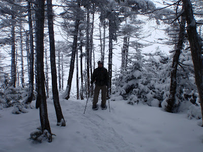
Summit of Mt. Osceola
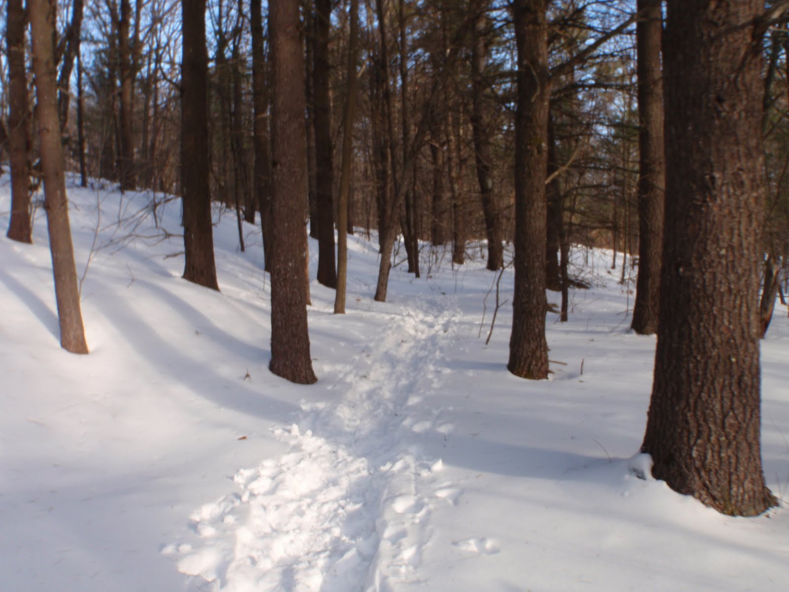
What an incredible undertaking this was to start my quest for NH's 48.  Now, just the second week into the year, Bill and I have two peaks under our belt. We started up the Greeley Pond Trail from the Kancamagus Highway exactly at 9am. We had the snowshoes on from the get-go, and we quickly got used to them. We did the first 1.3 miles in about an hour. When we got to the junction, we changed from the shoes to our Microspikes to switch it up and make headway as it got a bit steeper. After the junction, the trail is basically never flat again. Don't ever wish it will get flat, it won't.

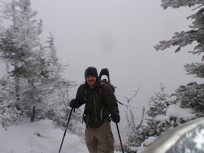
Dan on Osceola, East Peak
Bill on Osceola, East Peak
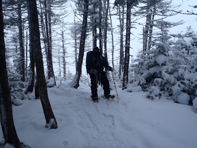
The higher we got on the trail, the heavier it was snowing and the heavier the winds. Microspikes worked well for a little while, then we put back on the snowshoes. It was no problem switching them out. the straps on the MSR Lightning Ascents are quick and easy to secure. 

As we approached the East Peak, it was snowing really good. After walking up a few steep spirals, it seemed, the trail flattens out slightly. The trees are pretty small, and we came across the small path that leads to a very small outlook, where all we saw was white. We continued on a short distance and found the true summit of Osceola East Peak. With visibility probably less than 100ft or so, there were no views to take in, except the howling winds blowing through the trees and the snow blowing about, or falling from the trees, which make a variety of different grinding noises from the wind. We still remembered to take a moment and reflect on the fact that this mission is now started.
Reached the top of the Bypass, safely

The Mt. Osceola Trail descends the East Peak, and then ascends Mt. Osceola. In between there is vertical section called the Chimney and the Bypass. We decided to take the Bypass for obvious reasons. It appeared much safer, although that did not make it easy. I can imagine it is much easier in the summer. The Bypass was covered with about 2 inches of powder as we ascended it. After this section the trail continues for at least another half mile before reaching the summit of Mt. Osceola.

The summit was fantastic, but extremely cold. We knew that there was a wind chill advisory for the afternoon at the higher summits, which forecasted winds at 40-60mph and wind chills to -40 degrees. From the time we hiked between the peaks along the ridges, our waters, which were inside of our packs, were becoming completely frozen. Our cameras were saying battery low, and just minutes after removing a glove, fingers started to get numb. This was a great test for us to see what these conditions are like. With our new hiking boots, our feet were toasty warm the entire time. Our clothing and layering choices had worked out perfectly all day long.  Although prepared for anything, we certainly did not expect it to snow all day long. It never stopped.

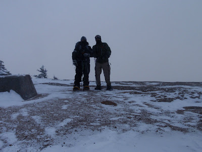
Me & Bill on the Summit of Osceola
After reaching our goal of Mt. Osceola, we headed back down, over, and out. Going down the mountain all the way from the summit of Osceola to below East Osceola, the trail was pretty difficult. There was one other hiker on trail, who headed back prior to us. His footprints had been covered by drifts up to approximately 8 inches or more. The trail seems so steep going down, it was so hard to believe we freakin' hiked up it. We had our Microspikes on because we needed some maneuverability going down. Even with the spikes, there were a couple of decent 10 feet slides down some ice, which made it interesting. What really got interesting was when Bill started sliding on one of the iciest sections and did not stop. In fact he slid about 10 feet before somehow ending up on his feet but still sliding another 5 feet or so before catching himself on a tree with his chest and arms. Had there been no tree, he'd be in some pine trees about 20 feet down.

I think it was a bit steeper than we expected overall.  Before we made it back to the junction with the Greeley Pond Trail, it was pretty dark, and we used our headlamps. Once we passed the junction, we moved pretty quickly through the 1.3 miles, which is much much flatter and easier than any other part of the trail on this trip. It's a pretty amazing thing to experience hiking in these conditions. To top the experience off, not many get to experience hiking during a blustery and chilly snowfall under a slither of bright moonlight.

Hike Stats
Trails: Greely Pond Trail, Mt. Osceola Trail
Distance: 7.6 mi
Elevation Gain: 3100 feet


Saturday, January 1, 2011

My Quest for NH's 48

Looking back at Madison Hut - 2010
So...it's January 1st, and after a 2010 full of a variety of outdoor activities, I've decided to set the goal of hiking all 48 of NH's 4000 foot mountains before 2012. It seems as if my previous hikes, including 3 of the 4000 footers, have lead me to establish this goal. I know that there are many more majestic views of nature to match the ones I've already seen. Some will be from the mountaintops, and certainly and hopefully, some great ones from within the trees and at camp. I'm not sure what it is, but when you reach the top of a mountain, you get a certain feeling of accomplishment, and while I have the ability to do these things with my free time, for now, I've chosen the outdoors to be my challenge. Each hike is different poses a different challenge each time. Right now, many miles of hiking, elevation gain, fighting the elements and all of the known dangers of the White Mountains stand in my way.

I know that this will not be easy. Split up evenly, it would require I summit 4 mountains per month without traverses, and not all can be traversed. In order to provide myself the best opportunity to complete this goal I've got to get started right away. Right away comes later this month, smack dab in the middle of winter, as I hope to begin this quest. I shall leave you with the element of surprise for my plans for now...

Be sure to check out my Quest for NH 48 page, which I have also just published today. I have created this page to track my progress. I will publish a post for each summit. Along the way, it should provide me an opportunity to keep updating my gear page with new pictures and videos.

Mt. Monadnock - New Year's Eve - December 31, 2010

After a stressful, but short week at work, I was wanting to take advantage of having Friday off (and it had been too long since I've hiked). After all, it was New Year's Eve, and it was a great morning for this hike to Mt. Monadnock. I read the most recent trail condition report and was aware that the area around Jaffrey did not receive as much snow as we did in MA. I got the Kahtoola MicroSPIKES for Christmas and I knew it would be the perfect place to try them out.

I left my house around 7AM, and broke trail from the parking lot on Route 124 exactly at 9:15am. There were a few cars in the lot, and a group of hikers getting ready to set off. I started up the trail, which parallels the Old Toll Road for a short distance, then goes into the woods. It travels over rolling terrain before there is any significant ascent. Along the trail, I guessed the snow to be anywhere from 6-8 inches. The path was packed pretty good, but it was not as flat or defined as it would be further up. I have hiked this trail twice before and recently in December, but the snow seemed to make the trail unfamiliar. There was a big group using snowshoes that approached as I took a water break. It was the group getting ready in the parking lot. I lessened my pace and benefited from them packing it out for me. I hiked behind them for about 10-15 minutes until we came to the junction, and then I darted up the trail to where the Old Halfway Trail joins the road halfway up and took another quick water break.

After I passed the open area and connected with the White Arrow Trail, I stopped to put on the micospikes. From here the trail begins to ascend quickly. This was the first time using the microspikes, and let me tell you these people are geniuses. The grip on them is amazing, and the pace I had going up the mountain was awesome. I was testing the grades of the ice and getting a feel for what kinds of ice and steps were too much for them. The reason they're genius is because every hiker on the mountain had them. The path on the White Arrow was packed out pretty well and was easy to follow. When there is no snow, a lot of the trail requires large steps and some rock scrambles, but the snow really made it interesting because I knew I was hiking well above the rocks that I scrambled over last month.

I stopped at the outlook for a few minutes to put on my REI Thermal Fleece and winter hat. It was warm so I was sweating and quickly felt the wind begin to cool my back, but the fleece kept me comfortable all the way up including while I sat at the summit. The climb from the outlook to the summit on the White Arrow was awesome in the snow. Along the way, I noticed many deep holes where a hiker's foot went 6-8 inches down between rocks. The microspikes were working awesome at the top of the mountain, and the pace I had going up was much faster than a pace I would have if there was no snow.

Once again, the summit was spectacular. The mountain seems so commandeering over the flat land below. I could see the northern mountains, Wachusett, and the Berkshires much better than in December. The low clouds made it feel a bit different, as if I was up higher. I enjoyed the summit for about 10-15 minutes while I woofed down a BLT I picked up at a local store along with some water. I posed for a couple of self-timed shots on the mountain, while another group of 3 were crackin' some beers for New Year's Eve. The wind on the summit was steady and chilly, but nothing drastic.

I knew that going down was going to be easy, despite what one would think. There were many hikers coming up on my way down to the outlook from the summit. I was so glad that I beat the crowds. I was plowing down the mountain at a very good pace. I left the microspikes on all the way down to the trail head. The warmer temperature made the snow softer than when I broke trail, so my gaiters certainly helped on the way down a few times when my foot went into deep snow, but they were not necessary at any other time. The good pace I had kept both up and down clocked this round trip in at exactly 3 hours. I had arrived at my car at 12:15pm. The climb was great, I was down early, and I was able to peacefully close the book on a fantastic 2010 of outdoor experiences. I am fortunate to have spent the last day of 2010 on top of a mountain, and then later on, ring in the new year hanging out with family. It's on to the next in 2011. I wish everyone a Happy New Year.

The video below shows the last six minutes to the summit and a 360 degree view. Enjoy!


Hike Stats
Trails: White Arrow Trail
Distance: 4.4 miles
Elevation Gain: 1,800 ft.
Actual Book Time: 5hrs